ISS003-E-5606

| NASA Photo ID | ISS003-E-5606 |
| Focal Length | 70mm |
| Date taken | 2001.09.15 |
| Time taken | 16:__:__ GMT |
Resolutions offered for this image:
1024 x 700 pixels 540 x 369 pixels 3060 x 2092 pixels 640 x 437 pixels 400 x 265 pixels
1024 x 700 pixels 540 x 369 pixels 3060 x 2092 pixels 640 x 437 pixels 400 x 265 pixels


Cloud masks available for this image:
Spacecraft nadir point:
Photo center point: 41.5° N, 112.5° W
Photo center point by machine learning:
Photo center point: 41.5° N, 112.5° W
Photo center point by machine learning:
Nadir to Photo Center:
Spacecraft Altitude: nautical miles (0km)
Country or Geographic Name: | USA-UTAH |
Features: | GREAT SALT LAKE |
| Features Found Using Machine Learning: | |
Cloud Cover Percentage: | 10 (1-10)% |
Sun Elevation Angle: | ° |
Sun Azimuth: | ° |
Camera: | Kodak DCS460 Electronic Still Camera |
Focal Length: | 70mm |
Camera Tilt: | |
Format: | 3060E: 3060 x 2036 pixel CCD, RGBG array |
Film Exposure: | |
| Additional Information | |
| Width | Height | Annotated | Cropped | Purpose | Links |
|---|---|---|---|---|---|
| 1024 pixels | 700 pixels | Photographic Highlights | Download Image | ||
| 540 pixels | 369 pixels | Photographic Highlights | Download Image | ||
| 3060 pixels | 2092 pixels | No | No | Download Image | |
| 640 pixels | 437 pixels | No | No | Download Image | |
| 400 pixels | 265 pixels | No | No | Photographic Highlights | Download Image |
Download Packaged File
Download a Google Earth KML for this Image
View photo footprint information
Download a GeoTIFF for this photo
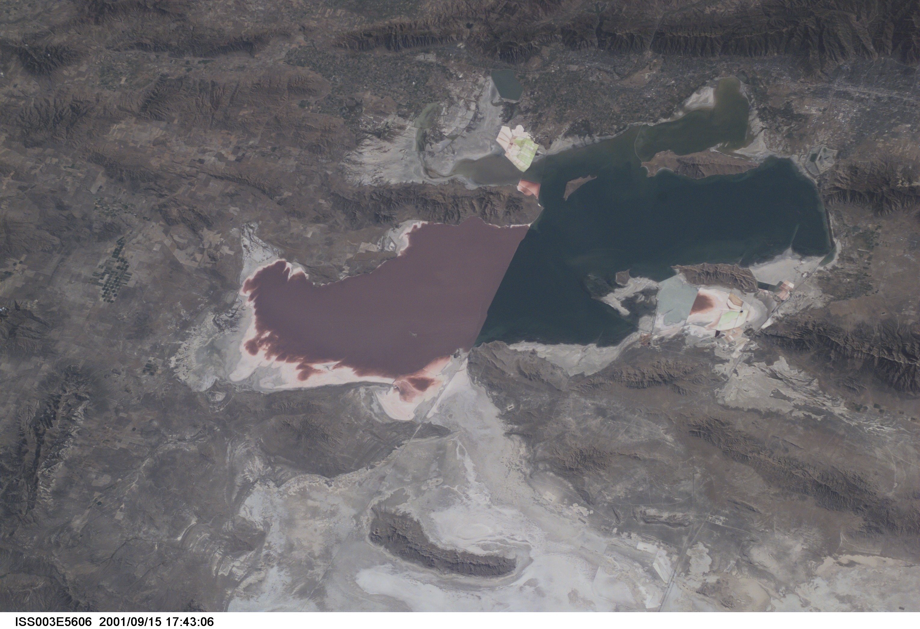
Image Caption: Great Salt Lake, Utah
The largest salt lake in the Western Hemisphere, The Great Salt Lake, was 20 times the size of the present lake at the end of the last Ice Age. Ancient Lake Bonneville covered portions of three states, Utah, Nevada, and Idaho, and drained via the present day Snake and Columbia Rivers into the Pacific Ocean. As seen in the east-looking view, today's Great Salt Lake is bounded to the east by the rugged Wasatch Range (upper portion of the image). To the west, is the Great Salt Lake Desert (bottom center of the image) once the lake bottom of the former Lake Bonneville. The Great Salt Lake is divided by an east to west railroad causeway. The saltier, purple-looking north part of the lake has no river inlet. The deeper, less salty, blue-looking south part of the lake is fed by fresh water from three rivers. The lake remains salty because it has no river outlet, and loses water only by evaporation. The depth and size of the Great Salt Lake varies from year to year depending on climatic conditions in the region. Table salt, potassium sulfate and other minerals are commonly extracted from the lake. Salt Lake City is discernible in the upper right portion of the image.
The largest salt lake in the Western Hemisphere, The Great Salt Lake, was 20 times the size of the present lake at the end of the last Ice Age. Ancient Lake Bonneville covered portions of three states, Utah, Nevada, and Idaho, and drained via the present day Snake and Columbia Rivers into the Pacific Ocean. As seen in the east-looking view, today's Great Salt Lake is bounded to the east by the rugged Wasatch Range (upper portion of the image). To the west, is the Great Salt Lake Desert (bottom center of the image) once the lake bottom of the former Lake Bonneville. The Great Salt Lake is divided by an east to west railroad causeway. The saltier, purple-looking north part of the lake has no river inlet. The deeper, less salty, blue-looking south part of the lake is fed by fresh water from three rivers. The lake remains salty because it has no river outlet, and loses water only by evaporation. The depth and size of the Great Salt Lake varies from year to year depending on climatic conditions in the region. Table salt, potassium sulfate and other minerals are commonly extracted from the lake. Salt Lake City is discernible in the upper right portion of the image.
