ISS001-E-5025
| NASA Photo ID | ISS001-E-5025 |
| Focal Length | 400mm |
| Date taken | 2000.12.__ |
| Time taken | GMT |
Resolutions offered for this image:
3054 x 2032 pixels 1200 x 798 pixels 3054 x 2032 pixels 540 x 359 pixels 3054 x 2032 pixels 3060 x 2092 pixels 640 x 437 pixels 640 x 437 pixels
3054 x 2032 pixels 1200 x 798 pixels 3054 x 2032 pixels 540 x 359 pixels 3054 x 2032 pixels 3060 x 2092 pixels 640 x 437 pixels 640 x 437 pixels


Cloud masks available for this image:
Spacecraft nadir point:
Photo center point: 31.0° N, 30.0° E
Photo center point by machine learning:
Photo center point: 31.0° N, 30.0° E
Photo center point by machine learning:
Nadir to Photo Center:
Spacecraft Altitude: nautical miles (0km)
Country or Geographic Name: | EGYPT |
Features: | ALEXANDRIA |
| Features Found Using Machine Learning: | |
Cloud Cover Percentage: | 10 (1-10)% |
Sun Elevation Angle: | ° |
Sun Azimuth: | ° |
Camera: | Kodak DCS460 Electronic Still Camera |
Focal Length: | 400mm |
Camera Tilt: | |
Format: | 3060E: 3060 x 2036 pixel CCD, RGBG array |
Film Exposure: | |
| Additional Information | |
| Width | Height | Annotated | Cropped | Purpose | Links |
|---|---|---|---|---|---|
| 3054 pixels | 2032 pixels | No | No | Cities collection | Download Image |
| 1200 pixels | 798 pixels | No | No | Cities collection | Download Image |
| 3054 pixels | 2032 pixels | No | No | Earth From Space collection | Download Image |
| 540 pixels | 359 pixels | Yes | No | Earth From Space collection | Download Image |
| 3054 pixels | 2032 pixels | No | No | NASA's Earth Observatory web site | Download Image |
| 3060 pixels | 2092 pixels | No | No | Download Image | |
| 640 pixels | 437 pixels | No | No | Download Image | |
| 640 pixels | 437 pixels | No | No | Download Image |
Download Packaged File
Download a Google Earth KML for this Image
View photo footprint information
Download a GeoTIFF for this photo
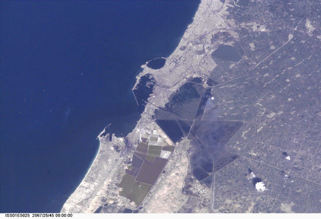
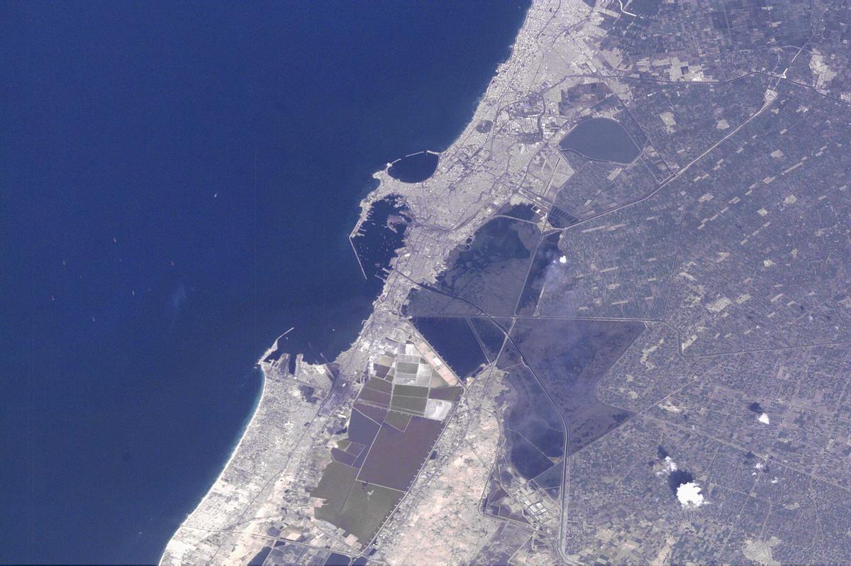
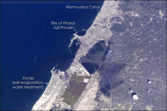
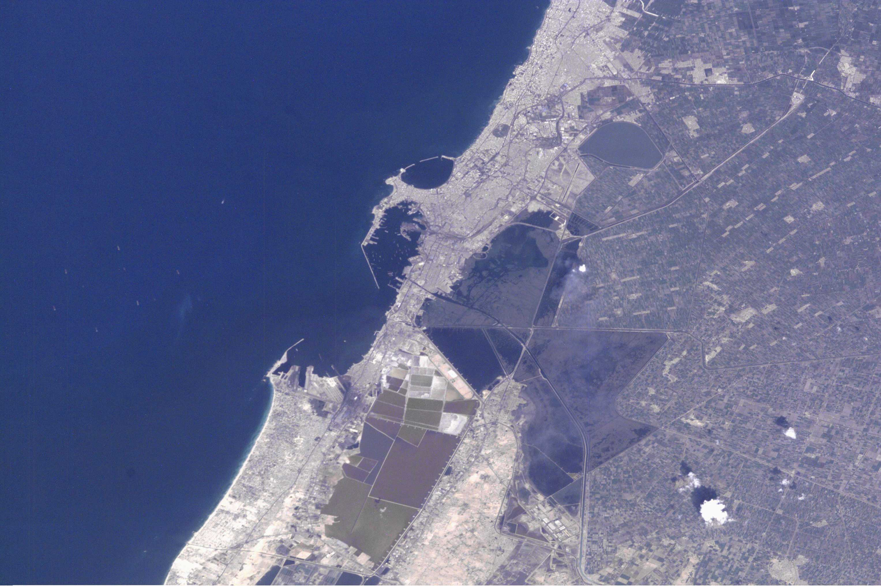
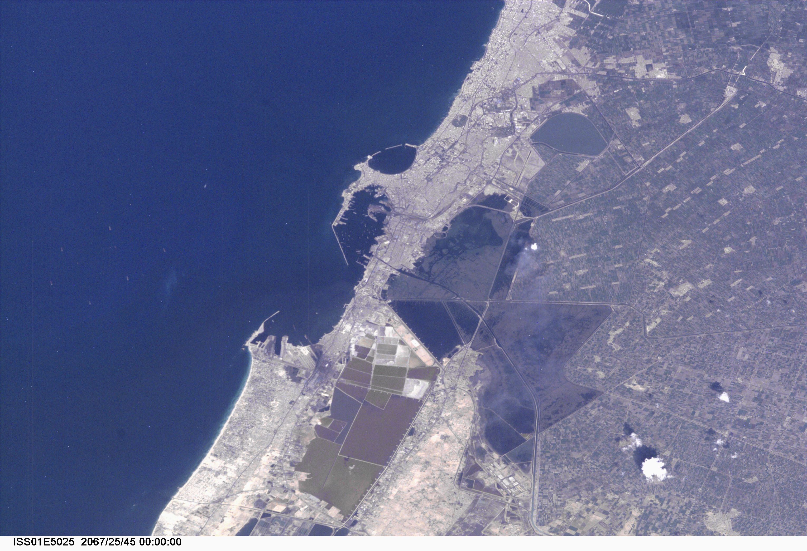
Image Caption: Alexandria (Al Iskandariya), Egypt
Alexandria (Al Iskandariya) occupies a T-shaped peninsula and strip of land separating the Mediterranean from Lake Mariout. Originally the town was built upon a mole (stone breakwater) called Heptastadium, which joined the island of Pharos to the mainland. Since then sedimentary deposits have added considerably to the width of the mole. Since 1905, when the city's 370 thousand inhabitants lived in an area of about 4 km2 between the two harbours, the city (population 4 million) has grown beyond its medieval walls and now occupies an area of about 300 km2. The Mahmudiya Canal, connecting Alexandria with the Nile, runs to the south of the city and, by a series of locks, enters the harbour of the principal port of Egypt (note ships). The reddish and ochre polygons west of Lake Mariout are salt-evaporation, chemical-storage, and water-treatment ponds within the coastal lagoon.
Some variation in water color seen in Mex Bay and the Western Harbour is due to municipal and industrial waste water entering the Mediterranean. The total cumulative volume of waste water disposed of into the sea from all point sources along this stretch of coast is about equal to the Nile outflow from the Rosetta outlet: roughly 9 million m3/day; that is, 3.33 km3/yr. Two thirds of the city waste water is released into Lake Mariout and subsequently pumped into Mex Bay, along with agricultural runoff from the northwestern delta. A few hundred meters from the foundered Pharos lighthouse, 200,000 m3 of waste water enter the sea each day at Qait Bey. The city government is building water treatment facilities and working to mitigate water-quality problems and to protect antiquities.
Alexandria was founded in 331 B.C. by Alexander the Great and served as the capital of Egypt for more than 1,000 years. The ruins of Pharos, the first lighthouse and one of the seven wonders of the ancient world, now lie beneath the Mediterranean. In about 295 B.C. Ptolemy I Soter began to construct the Great Library at Alexandria, the premier intellectual resource of the age; it was later destroyed by the caliph Umar in 640 A.D. The new Bibliotheca Alexandrina, being constructed by the Egyptian government in cooperation with UNESCO, is nearing completion and is due to open in spring, 2001.
