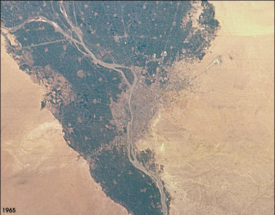
GEM05-1-45778
| NASA Photo ID | GEM05-1-45778 |
| Focal Length | 80mm |
| Date taken | 1965.08.__ |
| Time taken | GMT |
Resolutions offered for this image:
540 x 424 pixels 1054 x 842 pixels 2592 x 2572 pixels 400 x 315 pixels
540 x 424 pixels 1054 x 842 pixels 2592 x 2572 pixels 400 x 315 pixels


Cloud masks available for this image:
Spacecraft nadir point:
Photo center point: 30.5° N, 31.5° E
Photo center point by machine learning:
Photo center point: 30.5° N, 31.5° E
Photo center point by machine learning:
Nadir to Photo Center:
Spacecraft Altitude: nautical miles (0km)
Country or Geographic Name: | EGYPT |
Features: | CAIRO, NILE RIVER |
| Features Found Using Machine Learning: | |
Cloud Cover Percentage: | 0 (no clouds present) |
Sun Elevation Angle: | ° |
Sun Azimuth: | ° |
Camera: | Hasselblad |
Focal Length: | 80mm |
Camera Tilt: | |
Format: | SO217: Kodak Ektachrome with haze filter |
Film Exposure: | Normal |
| Additional Information | |
| Width | Height | Annotated | Cropped | Purpose | Links |
|---|---|---|---|---|---|
| 540 pixels | 424 pixels | Yes | Yes | NASA's Earth Observatory web site | Download Image |
| 1054 pixels | 842 pixels | No | NASA's Earth Observatory web site | Download Image | |
| 2592 pixels | 2572 pixels | No | No | Download Image | |
| 400 pixels | 315 pixels | No | Photographic Highlights | Download Image |
Download Packaged File
Download a Google Earth KML for this Image
View photo footprint information
Download a GeoTIFF for this photo
Image Caption: The population of the Cairo metropolitan area has increased from less than 6 million in 1965 when this picture was taken, to more than 10 million in 1998 (United Nations Population Division, World Urbanization Prospects, the 1999 revision). Population densities within the city are some of the highest in the world and the urban area has doubled to more than 400 square km during that period. Extraordinary rates of population growth are expected to continue, with a predicted population of around 14 million by 2015. Photographs of Earth taken from early space missions represent some of the earliest data on the state of the world's major cities.
