AS09-22-3345
| NASA Photo ID | AS09-22-3345 |
| Focal Length | 80mm |
| Date taken | 1969.03.08 |
| Time taken | 20:10:00 GMT |

Cloud masks available for this image:
Spacecraft nadir point:
Photo center point: 22.6° N, 77.1° W
Photo center point by machine learning:
Photo center point: 22.6° N, 77.1° W
Photo center point by machine learning:
Nadir to Photo Center:
Spacecraft Altitude: 105 nautical miles (194km)
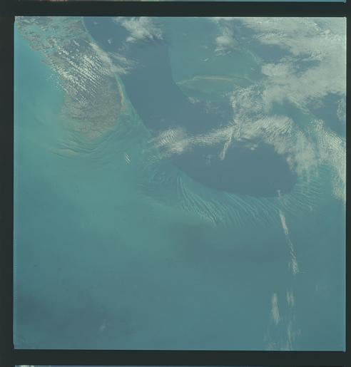
Country or Geographic Name: | BAHAMAS |
Features: | ANDROS ISLAND, SOUTH HALF |
| Features Found Using Machine Learning: | |
Cloud Cover Percentage: | 14 (11-25)% |
Sun Elevation Angle: | 52° |
Sun Azimuth: | ° |
Camera: | Hasselblad |
Focal Length: | 80mm |
Camera Tilt: | Near Vertical |
Format: | SO368: Kodak Ektachrome MS, equivalent to 2448 Kodak Aerochrome, ASA64, thin base, fine grain |
Film Exposure: | Normal |
| Additional Information | |
| Width | Height | Annotated | Cropped | Purpose | Links |
|---|---|---|---|---|---|
| 4400 pixels | 4600 pixels | No | No | Download Image | |
| 492 pixels | 515 pixels | No | No | Download Image |
Download Packaged File
Download a Google Earth KML for this Image
View photo footprint information
Download a GeoTIFF for this photo
Image Caption: GEOGRAPHY/CARTOGRAPHY: BAHAMA ISLANDS, ANDROS ISLAND, SNAP POINT, VILLAGE OF KEMP'S BAY.
GEOLOGY/HYDROLOGY: ELEVATED PLAINS OF MARINE ORIGIN.
FORESTRY: TROPICAL RAINFOREST AND COASTAL MANGROVE AND GRASSES.
METEOROLOGY: ALTO-CUMULUS, CIRRO-CUMULUS.
OCEANOGRAPHY: CARIBBEAN SEA, TONGUE OF THE OCEAN, BOTTOM TOPOGRAPHY OF AREAS ADJACENT TO THE DEEP CLEARLY VIVIBLE.
GEOLOGY/HYDROLOGY: ELEVATED PLAINS OF MARINE ORIGIN.
FORESTRY: TROPICAL RAINFOREST AND COASTAL MANGROVE AND GRASSES.
METEOROLOGY: ALTO-CUMULUS, CIRRO-CUMULUS.
OCEANOGRAPHY: CARIBBEAN SEA, TONGUE OF THE OCEAN, BOTTOM TOPOGRAPHY OF AREAS ADJACENT TO THE DEEP CLEARLY VIVIBLE.
