AS09-20-3128
| NASA Photo ID | AS09-20-3128 |
| Focal Length | 80mm |
| Date taken | 1969.03.12 |
| Time taken | 15:01:00 GMT |

Cloud masks available for this image:
Spacecraft nadir point:
Photo center point: 35.1° N, 75.7° W
Photo center point by machine learning:
Photo center point: 35.1° N, 75.7° W
Photo center point by machine learning:
Nadir to Photo Center:
Spacecraft Altitude: 116 nautical miles (215km)
Country or Geographic Name: | USA-NORTH CAROLINA |
Features: | CAPES LOOKOUT & HATTERAS |
| Features Found Using Machine Learning: | |
Cloud Cover Percentage: | 30 (26-50)% |
Sun Elevation Angle: | 40° |
Sun Azimuth: | ° |
Camera: | Hasselblad |
Focal Length: | 80mm |
Camera Tilt: | High Oblique |
Format: | SO368: Kodak Ektachrome MS, equivalent to 2448 Kodak Aerochrome, ASA64, thin base, fine grain |
Film Exposure: | Normal |
| Additional Information | |
| Width | Height | Annotated | Cropped | Purpose | Links |
|---|---|---|---|---|---|
| 4400 pixels | 4600 pixels | No | No | Download Image | |
| 492 pixels | 515 pixels | No | No | Download Image |
Download Packaged File
Download a Google Earth KML for this Image
View photo footprint information
Download a GeoTIFF for this photo
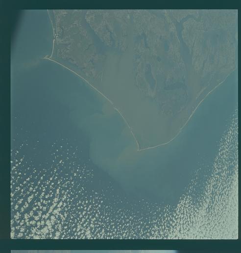
Image Caption: GEOGRAPHY/CARTOGRAPHY: UNITED STATES, NORTH CAROLINA, CAPE LOOKOUT, HATERA, AND HENRY, PAMILCO AND ALBEMARLE SOUNDS, MORHEAD CITY, ELIZABETH CITY, VIRGINA BEACH AND NORFOLK.
GEOLOGY/HYDROLOGY: COASTAL PLAIN REGION.
AGRICULTURE: SCATTERED FIELD PATTERNS.
FORESTRY: COASTAL MARSH GRASS WITH LOWLAND HARDWOOD FORESTS.
METEOROLOGY: ALTO-CUMULUS.
OCEANOGRAPHY: ATLANTIC OCEAN, SEDIMENT PATTERNS IN THE NEARSHORE ZONE.
Cape Hatteras, North Carolina area as photographed from the Apollo 9 spacecraft during its earth-orbital mission. The photograph was taken during the spacecraft's 136th revolution of the earth. Cape Lookout is near bottom of picture. Cape Hatteras juts the farthest out into the Atlantic. Largest inland body of water is Pamlico Sound; and to the north of it is Arbemarle Sound.
