AS07-8-1932
| NASA Photo ID | AS07-8-1932 |
| Focal Length | 80mm |
| Date taken | 1968.10.__ |
| Time taken | GMT |
Resolutions offered for this image:
5283 x 5230 pixels 639 x 633 pixels 2415 x 1811 pixels 540 x 681 pixels 4400 x 4600 pixels 400 x 396 pixels 492 x 515 pixels 2415 x 1811 pixels 2531 x 2579 pixels 1264 x 1278 pixels
5283 x 5230 pixels 639 x 633 pixels 2415 x 1811 pixels 540 x 681 pixels 4400 x 4600 pixels 400 x 396 pixels 492 x 515 pixels 2415 x 1811 pixels 2531 x 2579 pixels 1264 x 1278 pixels


Cloud masks available for this image:
Spacecraft nadir point:
Photo center point: 13.5° N, 14.5° E
Photo center point by machine learning:
Photo center point: 13.5° N, 14.5° E
Photo center point by machine learning:
Nadir to Photo Center:
Spacecraft Altitude: nautical miles (0km)
Country or Geographic Name: | CHAD |
Features: | LAKE CHAD, WINDOW OBSTRUCTION |
| Features Found Using Machine Learning: | |
Cloud Cover Percentage: | 20 (11-25)% |
Sun Elevation Angle: | ° |
Sun Azimuth: | ° |
Camera: | Hasselblad |
Focal Length: | 80mm |
Camera Tilt: | |
Format: | SO121: Kodak Ektachrome 64 |
Film Exposure: | Normal |
| Additional Information | |
| Width | Height | Annotated | Cropped | Purpose | Links |
|---|---|---|---|---|---|
| 5283 pixels | 5230 pixels | No | No | Earth From Space collection | Download Image |
| 639 pixels | 633 pixels | No | No | Earth From Space collection | Download Image |
| 2415 pixels | 1811 pixels | NASA's Earth Observatory web site | Download Image | ||
| 540 pixels | 681 pixels | Yes | Yes | NASA's Earth Observatory web site | Download Image |
| 4400 pixels | 4600 pixels | No | No | Download Image | |
| 400 pixels | 396 pixels | No | No | Photographic Highlights | Download Image |
| 492 pixels | 515 pixels | No | No | Download Image | |
| 2415 pixels | 1811 pixels | No | NASA's Earth Observatory web site | Download Image | |
| 2531 pixels | 2579 pixels | No | No | Download Image | |
| 1264 pixels | 1278 pixels | No | No | Download Image |
Download Packaged File
Download a Google Earth KML for this Image
View photo footprint information
Download a GeoTIFF for this photo
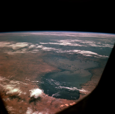
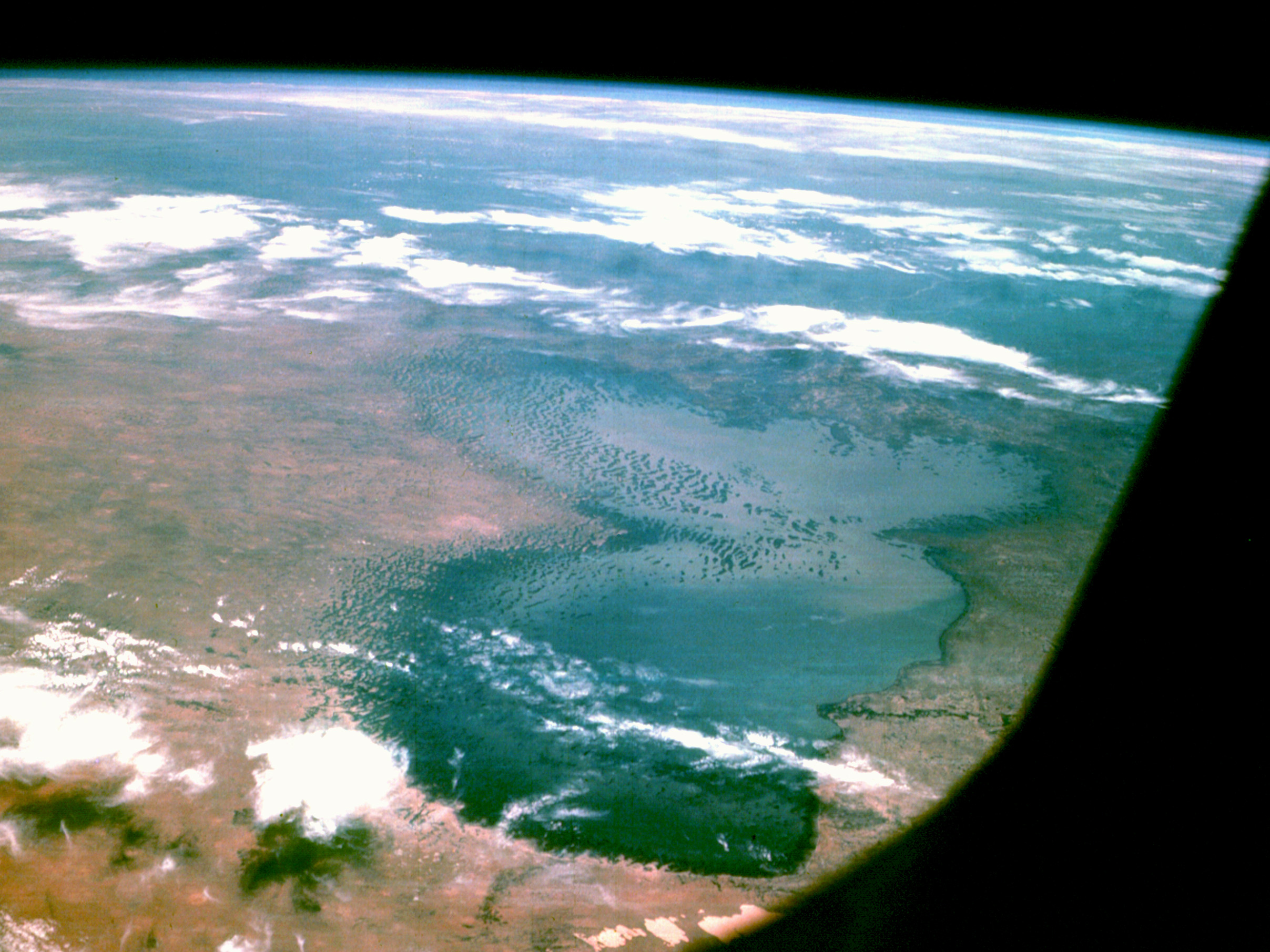
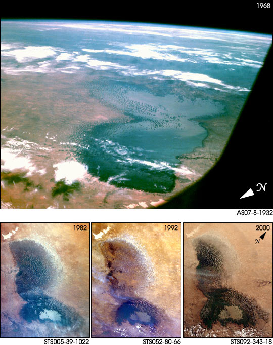
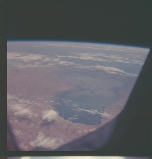
Image Caption: AS07-8-1932 Lake Chad, Africa October 1968
The north and south basins of Lake Chad are visible in this southeast-looking, high-oblique photograph. The boundaries and depth of the lake fluctuate from season to season and year to year. Lake Chad is the 4th largest lake in Africa and the 17th largest lake in the world, covering an area of nearly 6000 square miles (16 000 square kilometers). The average depth of the lake in the north is only 10 feet (3 meters), whereas the average depth in the south is nearly 20 feet (6 meters). The lake is fed by two major rivers, the Chari and the Komadugu Gana, and by many lesser streams; but, it has no outlet. Lake Chad is a freshwater lake, which is very unusual for a desert lake. During periods of adequate rainfall, runoff accumulates in the basin, filling Lake Chad and permitting extensive agriculture and local fishing. Located on the southern boundary of the Sahara Desert, Lake Chad contains numerous sand dunes or islets in both its northern and its southern basin. Two million years ago, when the climate was much wetter, Lake Chad covered a large portion of the south-central Sahara Desert. As the climate became drier and some geologic uplifting occurred to the south of the lake, sending rivers that had been draining into the lake southward into the Congo Basin, the lake shrank to little more than 10 percent of its original size. Lake Chad continues to shrink because of droughts that plague that region of Africa. The northern basin, which is almost completely cut off from the southern basin by a ridge known as the Great Barrier, is especially vulnerable to any short-term changes resulting from drought conditions and excessive evaporation. The position of Lake Chad and the sensitivity of the lake to changes in regional rainfall make the site an ideal focus for drought impact studies using satellite data and astronaut photography.
The north and south basins of Lake Chad are visible in this southeast-looking, high-oblique photograph. The boundaries and depth of the lake fluctuate from season to season and year to year. Lake Chad is the 4th largest lake in Africa and the 17th largest lake in the world, covering an area of nearly 6000 square miles (16 000 square kilometers). The average depth of the lake in the north is only 10 feet (3 meters), whereas the average depth in the south is nearly 20 feet (6 meters). The lake is fed by two major rivers, the Chari and the Komadugu Gana, and by many lesser streams; but, it has no outlet. Lake Chad is a freshwater lake, which is very unusual for a desert lake. During periods of adequate rainfall, runoff accumulates in the basin, filling Lake Chad and permitting extensive agriculture and local fishing. Located on the southern boundary of the Sahara Desert, Lake Chad contains numerous sand dunes or islets in both its northern and its southern basin. Two million years ago, when the climate was much wetter, Lake Chad covered a large portion of the south-central Sahara Desert. As the climate became drier and some geologic uplifting occurred to the south of the lake, sending rivers that had been draining into the lake southward into the Congo Basin, the lake shrank to little more than 10 percent of its original size. Lake Chad continues to shrink because of droughts that plague that region of Africa. The northern basin, which is almost completely cut off from the southern basin by a ridge known as the Great Barrier, is especially vulnerable to any short-term changes resulting from drought conditions and excessive evaporation. The position of Lake Chad and the sensitivity of the lake to changes in regional rainfall make the site an ideal focus for drought impact studies using satellite data and astronaut photography.
