AS07-7-1826
| NASA Photo ID | AS07-7-1826 |
| Focal Length | 80mm |
| Date taken | 1968.10.__ |
| Time taken | GMT |

Cloud masks available for this image:
Spacecraft nadir point:
Photo center point: 23.5° S, 69.5° W
Photo center point by machine learning:
Photo center point: 23.5° S, 69.5° W
Photo center point by machine learning:
Nadir to Photo Center:
Spacecraft Altitude: nautical miles (0km)
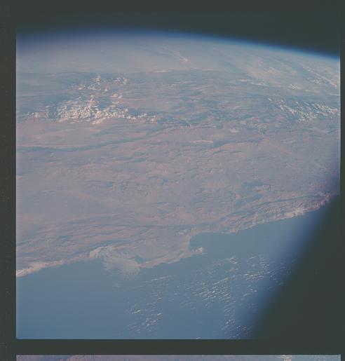
Country or Geographic Name: | CHILE |
Features: | ANTOFAGASTA, ATACAMA DES. |
| Features Found Using Machine Learning: | |
Cloud Cover Percentage: | 10 (1-10)% |
Sun Elevation Angle: | ° |
Sun Azimuth: | ° |
Camera: | Hasselblad |
Focal Length: | 80mm |
Camera Tilt: | High Oblique |
Format: | SO121: Kodak Ektachrome 64 |
Film Exposure: | Normal |
| Additional Information | |
| Width | Height | Annotated | Cropped | Purpose | Links |
|---|---|---|---|---|---|
| 4400 pixels | 4600 pixels | No | No | Download Image | |
| 492 pixels | 515 pixels | No | No | Download Image |
Download Packaged File
Download a Google Earth KML for this Image
View photo footprint information
Download a GeoTIFF for this photo
Image Caption: This view of South America as seen from the Apollo 7 spacecraft during its 81st revolution of the earth from an altitude of 120 nautical miles. The port city of Antofagasta, Chile, is located in the half-moon shaped bay in the lower left portion of the picture. Beyond the coast is the Andean peak of Liullaillaco Volcano which rises 22,000 ft above sea level. At left center is the Chuquicamata copper mines located near Coloma. At the center of the photo, behind the large salt lake and atop a 19,000 ft high volcano, the countries of Bolivia, Argentina, and Chile meet at a common point. Below the clouds in the upper portion of the photo are the great plains known as the Gran Chaco.
