AS06-2-1485
| NASA Photo ID | AS06-2-1485 |
| Focal Length | 76mm |
| Date taken | 1968.04.04 |
| Time taken | GMT |

Cloud masks available for this image:
Spacecraft nadir point:
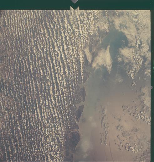
Photo center point: 31.5° N, 81.5° W
Photo center point by machine learning:
Photo center point: 31.5° N, 81.5° W
Photo center point by machine learning:
Nadir to Photo Center:
Spacecraft Altitude: nautical miles (0km)
Country or Geographic Name: | USA-GEORGIA |
Features: | BRUNSWICK TO SAVANNAH |
| Features Found Using Machine Learning: | |
Cloud Cover Percentage: | 70 (51-75)% |
Sun Elevation Angle: | ° |
Sun Azimuth: | ° |
Camera: | Maurer model 220G |
Focal Length: | 76mm |
Camera Tilt: | Near Vertical |
Format: | SO121: Kodak Ektachrome 64 |
Film Exposure: | Normal |
| Additional Information | |
| Width | Height | Annotated | Cropped | Purpose | Links |
|---|---|---|---|---|---|
| 4400 pixels | 4600 pixels | No | No | Download Image | |
| 492 pixels | 515 pixels | No | No | Download Image |
Download Packaged File
Download a Google Earth KML for this Image
View photo footprint information
Download a GeoTIFF for this photo
Image Caption: View of the east coast of the United States as photographed from the Apollo 6 (Spacecraft 020/Saturn 502) unmanned space mission. This photograph was taken during a pass over Georgia, between Savannah and Brunswick. Altitude of the spacecraft was 100 nautical miles. Numerous jet aircraft contrails can be seen over the Atlantic Ocean. Sun glint on the surface of the ocean permits oceanographers to determine conditions of the water.
