< STS043-152-CT >
| NASA Photo ID | STS043-152-CT |
| Focal Length | 250mm |
| Date taken | 1991.08.__ |
| Time taken | GMT |
Resolutions offered for this image:
640 x 480 pixels
640 x 480 pixels
Cloud masks available for this image:
Spacecraft nadir point:
Photo center point: 16.5° S, 72.5° W
Photo center point by machine learning:
Photo center point: 16.5° S, 72.5° W
Photo center point by machine learning:
Nadir to Photo Center:
Spacecraft Altitude: nautical miles (0km)Body: Earth
Country or Geographic Name: | PERU |
Features: | COAST, CAMANA AREA, FARMING |
| Features Found Using Machine Learning: | |
Cloud Cover Percentage: | 40 (26-50)% |
Sun Elevation Angle: | ° |
Sun Azimuth: | ° |
Camera: | Linhof |
Focal Length: | 250mm |
Camera Tilt: | Low Oblique |
Format: | QX868: Kodak, natural color positive, Ektachrome QX868(5017 emulsion), ASA 64, thin base |
Film Exposure: | Normal |
| Additional Information | |
| Width | Height | Annotated | Cropped | Purpose | Links |
|---|---|---|---|---|---|
| 640 pixels | 480 pixels | No | No | ISD 1 | Download Image |
Download Packaged File
Download a Google Earth KML for this Image
View photo footprint information
No GeoTIFF is available for this photo.Image Caption:
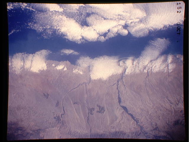
S43-152-CT - Coastal Desert of Peru
The coast of Peru, between the Pacific Ocean and coast ranges of
the Andes Mountains, is extremely arid. Water does flow through
canyons to the coast, and has been used for flood- and canal-
irrigation agriculture during the past several thousand years.
During the past decade or so, ground water within the mountain-
flanking sedimentary rocks has been tapped for well-irrigation
agriculture. Several large irrigated patches can be seen in this
frame within the piedmont zone. Linhof camera, 250mm lens
The coast of Peru, between the Pacific Ocean and the Andes Mountains is very arid (16.5S, 72.5W). For several thousand years, water from numerous small streams has been used for traditional flood and canal irrigation agriculture. However, during the past decade innovative techniques have tapped new water sources for increased agricultural production. Ground water in the porous sedimentary rock formations has been tapped for well irrigation agriculture.
S43-152-CT - Coastal Desert of Peru
The coast of Peru, between the Pacific Ocean and coast ranges of
the Andes Mountains, is extremely arid. Water does flow through
canyons to the coast, and has been used for flood- and canal-
irrigation agriculture during the past several thousand years.
During the past decade or so, ground water within the mountain-
flanking sedimentary rocks has been tapped for well-irrigation
agriculture. Several large irrigated patches can be seen in this
frame within the piedmont zone. Linhof camera, 250mm lens
The coast of Peru, between the Pacific Ocean and the Andes Mountains is very arid (16.5S, 72.5W). For several thousand years, water from numerous small streams has been used for traditional flood and canal irrigation agriculture. However, during the past decade innovative techniques have tapped new water sources for increased agricultural production. Ground water in the porous sedimentary rock formations has been tapped for well irrigation agriculture.

