< STS069-721-91 >
| NASA Photo ID | STS069-721-91 |
| Focal Length | 100mm |
| Date taken | 1995.09.11 |
| Time taken | 06:57:36 GMT |
Resolutions offered for this image:
4043 x 4085 pixels 633 x 640 pixels 5700 x 5900 pixels 500 x 518 pixels 640 x 480 pixels 522 x 511 pixels
4043 x 4085 pixels 633 x 640 pixels 5700 x 5900 pixels 500 x 518 pixels 640 x 480 pixels 522 x 511 pixels


Cloud masks available for this image:
Spacecraft nadir point: 7.8° S, 118.0° E
Photo center point: 8.5° S, 119.0° E
Photo center point by machine learning:
Photo center point: 8.5° S, 119.0° E
Photo center point by machine learning:
Nadir to Photo Center: Southeast
Spacecraft Altitude: 215 nautical miles (398km)
Country or Geographic Name: | INDONESIA |
Features: | SUMBAWA, KOMODO ISLAND |
| Features Found Using Machine Learning: | |
Cloud Cover Percentage: | 10 (1-10)% |
Sun Elevation Angle: | 45° |
Sun Azimuth: | 285° |
Camera: | Hasselblad |
Focal Length: | 100mm |
Camera Tilt: | 19 degrees |
Format: | 5046: Kodak, natural color positive, Lumiere 100/5046, ASA 100, standard base |
Film Exposure: | Normal |
| Additional Information | |
| Width | Height | Annotated | Cropped | Purpose | Links |
|---|---|---|---|---|---|
| 4043 pixels | 4085 pixels | No | No | Earth From Space collection | Download Image |
| 633 pixels | 640 pixels | No | No | Earth From Space collection | Download Image |
| 5700 pixels | 5900 pixels | No | No | Download Image Download Color Calibration Image for this Image |
|
| 500 pixels | 518 pixels | No | No | Download Image Download Color Calibration Image for this Image |
|
| 640 pixels | 480 pixels | No | No | Download Image | |
| 522 pixels | 511 pixels | Download Image |
Download Packaged File
Download a Google Earth KML for this Image
View photo footprint information
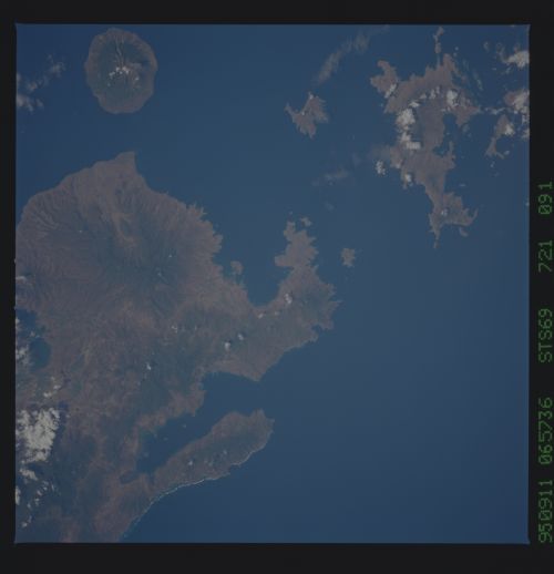
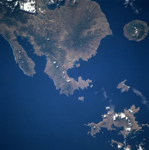
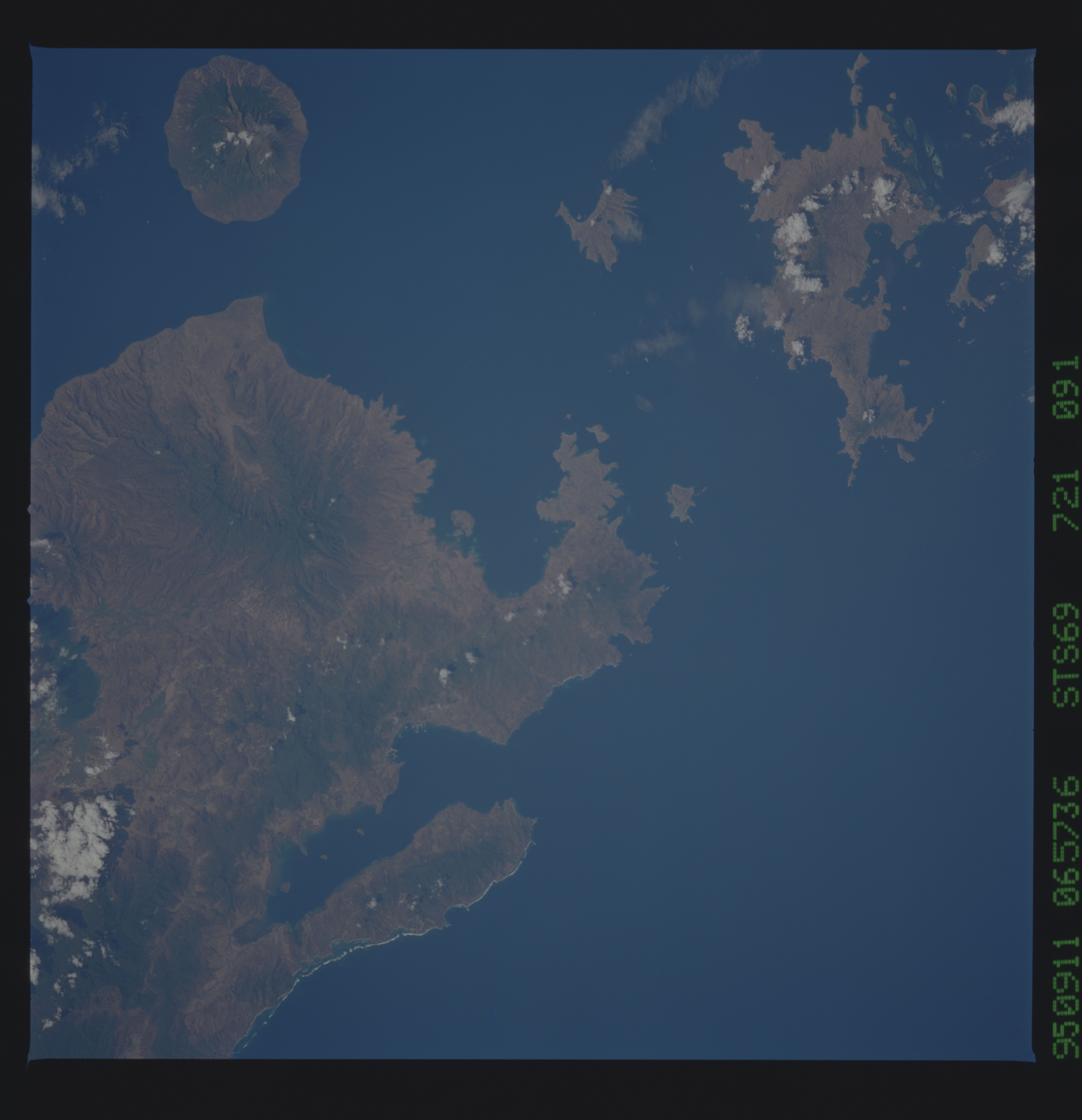
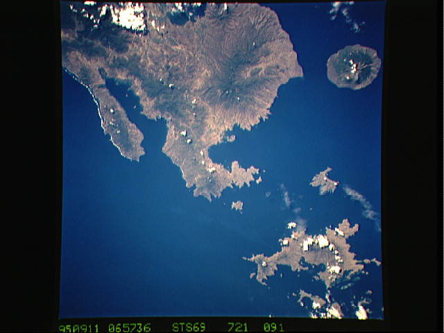
No GeoTIFF is available for this photo.Image Caption: STS069-721-091 Sumbawa, Komodo, and Sangeang Islands, Indonesia September 1995
Several volcanic islands in the Indonesian Archipelago are visible in this near-nadir view. The eastern end of Sumbawa Island (top center), Sangeang Island (small, oval-shaped in the upper right) and Komodo Island (irregular-shaped coastline in the bottom right) are the most prominent. Sumbawa Island has many volcanic peaks, including the dormant Gunung Daria located to the right midway between the center and upper center of the image. The slopes of the volcanoes and other mountains are forest-covered. The soils of the island are very fertile. Tropical fruit and rice are grown. To the north-northeast of Sumbawa near the upper right portion of the image is the 8-mile (13 km) wide Sangeang Island and one of the more active stratovolcano's in Indonesia, Api. The volcano is actually made up of two volcanic peaks, the highest at 6293 feet (1949 meters) and the other at 5888 feet (1795 meters). Api has been very active throughout the 20th Century. Just to the east of Sumbawa Island is the Sapa Strait. Near the bottom right of the image is Komodo Island. The island, which is very wild and rugged, is 25 miles (40 km) long and 12 miles (19 km) wide and is home to the world famous Komodo Dragon, one of the largest reptiles in the world. The Sumba Strait covers the bottom left portion of the image.
Several volcanic islands in the Indonesian Archipelago are visible in this near-nadir view. The eastern end of Sumbawa Island (top center), Sangeang Island (small, oval-shaped in the upper right) and Komodo Island (irregular-shaped coastline in the bottom right) are the most prominent. Sumbawa Island has many volcanic peaks, including the dormant Gunung Daria located to the right midway between the center and upper center of the image. The slopes of the volcanoes and other mountains are forest-covered. The soils of the island are very fertile. Tropical fruit and rice are grown. To the north-northeast of Sumbawa near the upper right portion of the image is the 8-mile (13 km) wide Sangeang Island and one of the more active stratovolcano's in Indonesia, Api. The volcano is actually made up of two volcanic peaks, the highest at 6293 feet (1949 meters) and the other at 5888 feet (1795 meters). Api has been very active throughout the 20th Century. Just to the east of Sumbawa Island is the Sapa Strait. Near the bottom right of the image is Komodo Island. The island, which is very wild and rugged, is 25 miles (40 km) long and 12 miles (19 km) wide and is home to the world famous Komodo Dragon, one of the largest reptiles in the world. The Sumba Strait covers the bottom left portion of the image.
