< ISS044-E-899 >

| NASA Photo ID | ISS044-E-899 |
| Focal Length | 1150mm |
| Date taken | 2015.06.11 |
| Time taken | 05:21:40 GMT |


Spacecraft nadir point: 16.1° S, 121.1° E
Photo center point:
Photo center point by machine learning: 15.53° S, 123.16° E
Photo center point:
Photo center point by machine learning: 15.53° S, 123.16° E
Nadir to Photo Center:
Spacecraft Altitude: 217 nautical miles (402km)

Country or Geographic Name: | |
Features: | |
| Features Found Using Machine Learning: | |
Cloud Cover Percentage: | 1 (1-10)% |
Sun Elevation Angle: | 46° |
Sun Azimuth: | 331° |
Camera: | NIKON D4 S/N: 2071127 |
Focal Length: | 1150mm |
Camera Tilt: | |
Format: | |
Film Exposure: | |
| Additional Information | |
| Width | Height | Annotated | Cropped | Purpose | Links |
|---|---|---|---|---|---|
| 4928 pixels | 3280 pixels | No | No | Download Image | |
| 640 pixels | 426 pixels | No | No | Download Image |
Download Packaged File
Download a Google Earth KML for this Image
View photo footprint information
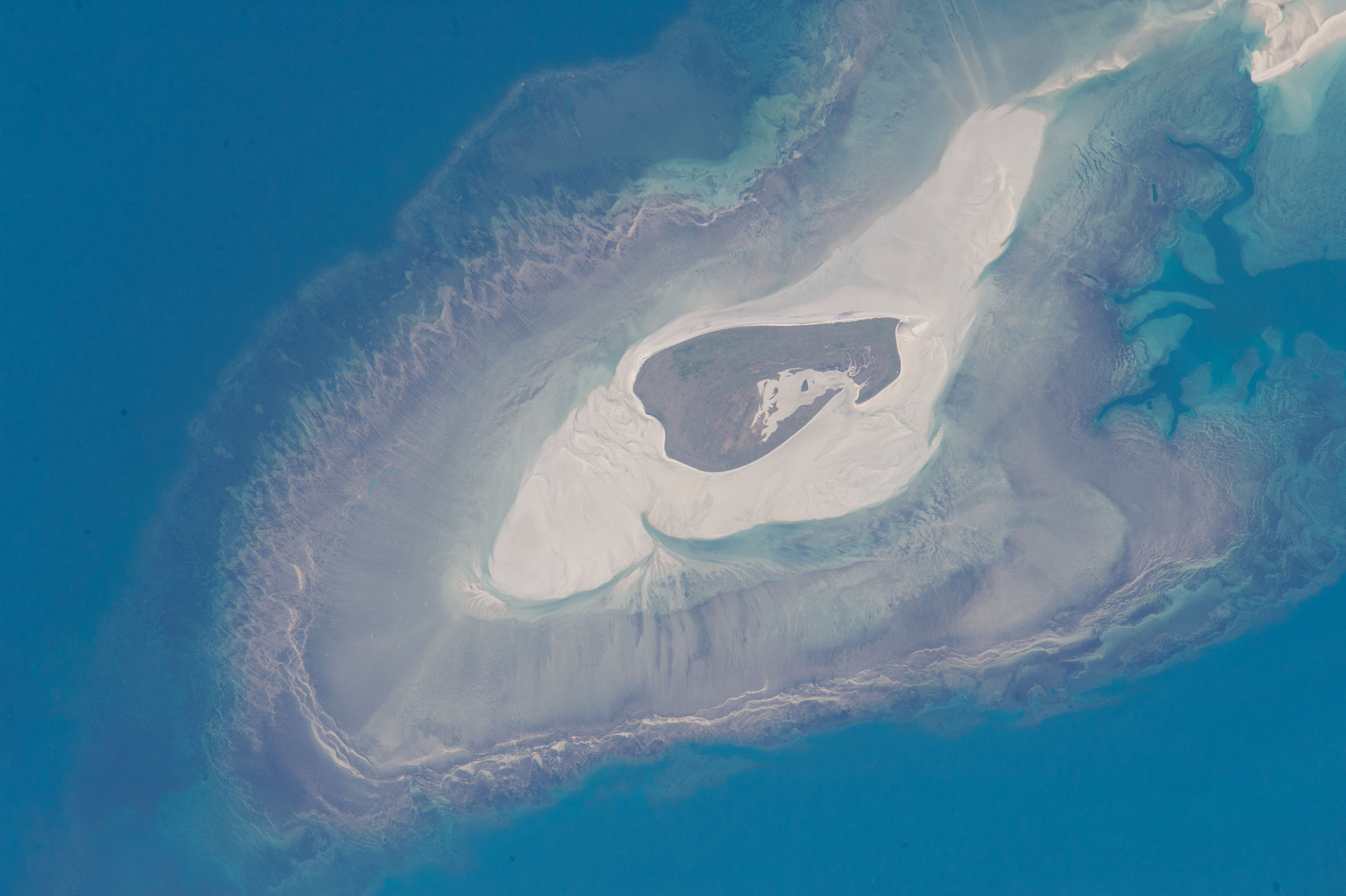
No GeoTIFF is available for this photo.Image Caption: Adele Island, Northwest Australia
Astronauts aboard the International Space Station took this detailed image of Adele Island, off Australia's north coast. The island is only 2.9 km (2 mi) long, but the entire tidal zone with all the concentric zones of extensive sandbanks is 24.5 km (15.2 mi) long. The modern island is the dark central area, made up of a series of beach ridges built by sands from the surrounding sandbank during storms. The highest point is little more than 4 m (12 feet) above sea level on this grassy but treeless island. The island has been classified as an Important Bird Area because it is a breeding site of world importance for Lesser Frigatebirds and three other species. Efforts are under way to clear the island of Polynesian rats that are a constant threat to the seabirds.
Lines on the wide platform around the island, at right angles to the shoreline, are probably produced by the high tides (6.3 m, ~20 feet, at nearby Browse Island), as water floods towards the island, and then ebbs back out to sea--a "radial" pattern common on islands in this part of the world. Wave and tide movements give different sand patterns on opposite sides of Adele Island. The eastern shore shows tightly packed parallel lines of white sand (bottom of the image), perhaps as a result of wave action concentrated in a narrow zone related to this steep slope. On the gentler western slope (image top left) the same sandy material displays a V-shaped pattern possibly due to the longer in-out movement of water with each tide.
Shallow water surrounding the island is light blue, compared with the deeper open ocean (upper left, lower right). During times of low sea level (repeatedly during the glacial stages of the past 1.7 million years), the entire platform and surrounding zones would have been dry ground--so that astronauts would have seen a much larger island occupying the entire area of the image
