< STS082-731-83 >

| NASA Photo ID | STS082-731-83 |
| Focal Length | 250mm |
| Date taken | 1997.02.13 |
| Time taken | 13:50:28 GMT |

Cloud masks available for this image:
Spacecraft nadir point: 12.5° N, 88.4° W
Photo center point: 13.0° N, 87.5° W
Photo center point by machine learning:
Photo center point: 13.0° N, 87.5° W
Photo center point by machine learning:
Nadir to Photo Center: Northeast
Spacecraft Altitude: 317 nautical miles (587km)
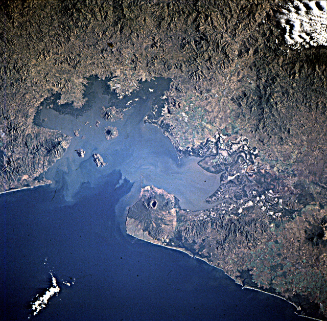
Country or Geographic Name: | HONDURAS |
Features: | GULF OF FONSECA |
| Features Found Using Machine Learning: | |
Cloud Cover Percentage: | 5 (1-10)% |
Sun Elevation Angle: | 21° |
Sun Azimuth: | 110° |
Camera: | Hasselblad |
Focal Length: | 250mm |
Camera Tilt: | 11 degrees |
Format: | 5069: Kodak Elite 100S, E6 Reversal, Replaces Lumiere, Warmer in tone vs. Lumiere |
Film Exposure: | Normal |
| Additional Information | |
| Width | Height | Annotated | Cropped | Purpose | Links |
|---|---|---|---|---|---|
| 5700 pixels | 5900 pixels | No | No | Download Image Download Color Calibration Image for this Image |
|
| 483 pixels | 500 pixels | No | No | Download Image Download Color Calibration Image for this Image |
|
| 640 pixels | 628 pixels | No | No | Photographic Highlights | Download Image |
Download Packaged File
Download a Google Earth KML for this Image
View photo footprint information
No GeoTIFF is available for this photo.Image Caption: El Salvador, Honduras, Nicaragua. Detailed nadir view of Golfo de
Fonseca and Cosiguina volcano. The explosion of Cosiguina in August,
1859 has been the largest historical eruption to date in the western
hemisphere. The volcano developed at the intersection of two
structural complexes -- a bend in the convergent plate margin, and a
north-trending fault valley (graben) that intersects the volcanic arc.
Amapala, on the flank of another volcano, is the port for
Honduras. Extensive maricultural development can be observed in the
eastern gulf.
