ISS015-E-7874

| NASA Photo ID | ISS015-E-7874 |
| Focal Length | 180mm |
| Date taken | 2007.05.12 |
| Time taken | 08:25:20 GMT |
Resolutions offered for this image:
1000 x 660 pixels 540 x 356 pixels 540 x 334 pixels 3032 x 2064 pixels 639 x 435 pixels
1000 x 660 pixels 540 x 356 pixels 540 x 334 pixels 3032 x 2064 pixels 639 x 435 pixels


Spacecraft nadir point: 48.0° N, 52.1° E
Photo center point: 45.2° N, 60.8° E
Photo center point by machine learning:
Photo center point: 45.2° N, 60.8° E
Photo center point by machine learning:
Nadir to Photo Center: East
Spacecraft Altitude: 177 nautical miles (328km)
Country or Geographic Name: | KAZAKHSTAN |
Features: | DUST STORM, ARAL SEA |
| Features Found Using Machine Learning: | |
Cloud Cover Percentage: | 10 (1-10)% |
Sun Elevation Angle: | 60° |
Sun Azimuth: | 179° |
Camera: | Kodak DCS760c Electronic Still Camera |
Focal Length: | 180mm |
Camera Tilt: | High Oblique |
Format: | 3060E: 3060 x 2036 pixel CCD, RGBG array |
Film Exposure: | |
| Additional Information | |
| Width | Height | Annotated | Cropped | Purpose | Links |
|---|---|---|---|---|---|
| 1000 pixels | 660 pixels | No | Yes | Earth From Space collection | Download Image |
| 540 pixels | 356 pixels | Yes | Yes | Earth From Space collection | Download Image |
| 540 pixels | 334 pixels | Yes | Yes | NASA's Earth Observatory web site | Download Image |
| 3032 pixels | 2064 pixels | No | No | Download Image | |
| 639 pixels | 435 pixels | No | No | Download Image |
Download Packaged File
Download a Google Earth KML for this Image
View photo footprint information
Download a GeoTIFF for this photo
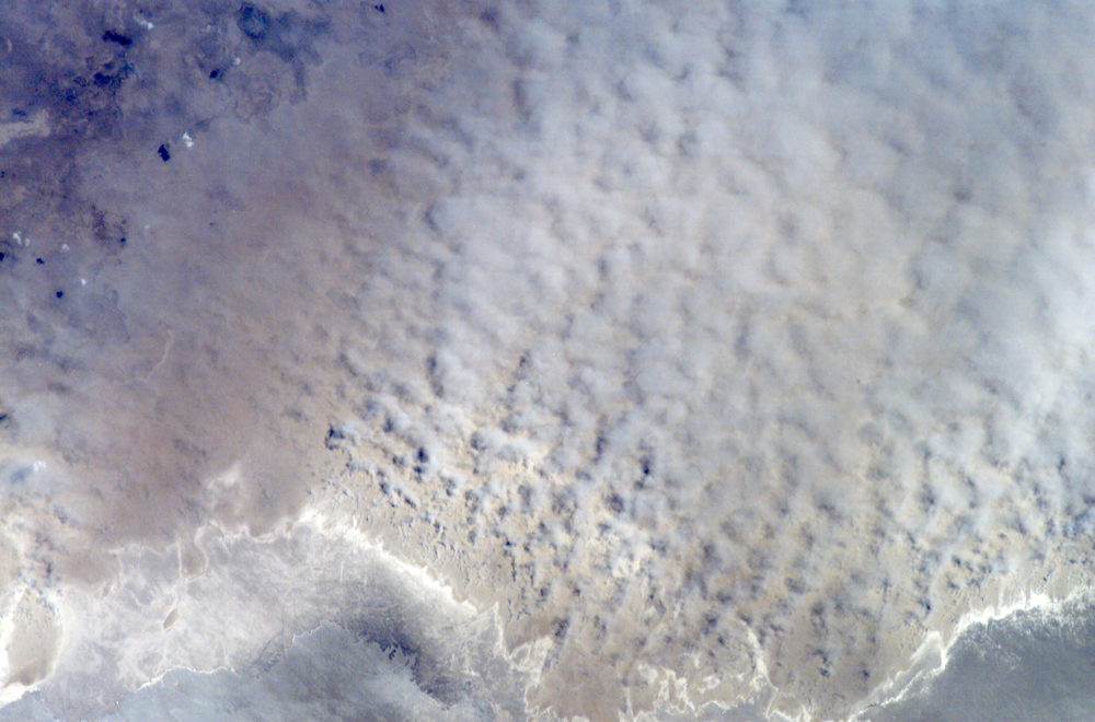
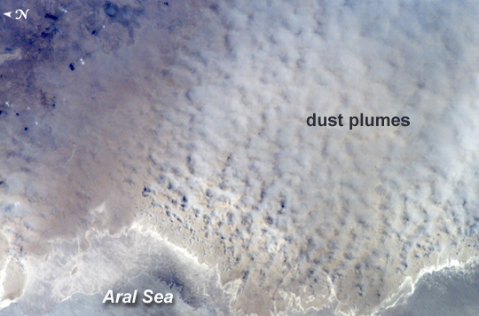
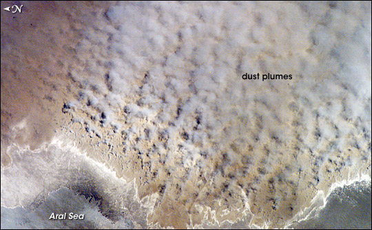
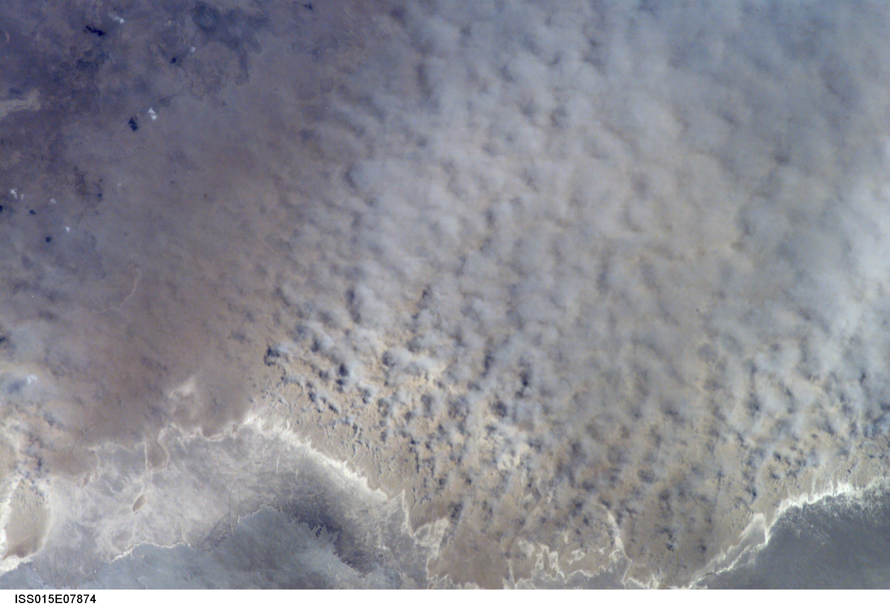
Image Caption: ISS015-E-07874 (12 May 2007) --- A major dust storm (center right) along the east side of the Aral Sea, Kazakhstan, is featured in this image photographed by an Expedition 15 crewmember on the International Space Station while passing over central Asia. The white, irregular lines along the bottom of the image are salt and clay deposits on the present coastline. On the spring day when the ISS crew shot the image, winds were blowing from the west (lower left). The gray, puffy appearance is typical of dust clouds, allowing scientists to distinguish dust from fog and smog. The dust in this image is rising from the sea bed of the Aral Sea, from a point close to the middle of the original Aral Sea of 40--50 years ago, then the fourth largest inland sea on Earth. Heavy extraction of water from the main supply river, the Amu Dary'a, has resulted in rapid shrinking of the sea. According to scientists, dust storms have been occurring in the Aral Sea region for thousands of years, but since the drastic shrinking of the sea over the past half-century an important change in dust composition has occurred. The dust now includes fertilizer and pesticide washed into the Sea from the extensive cotton fields of the Amu Dary'a floodplain. Years of liberal application of agricultural chemicals have resulted in concentration of these pollutants on the sea bed. These are now exposed to the wind and transported hundreds of kilometers in a generally easterly direction. Research suggests that the remobilized chemicals are the cause of high rates of many diseases in the populations along the north, east and southern margins of the Aral Sea. This is one of the unintended consequences of the shrinking of the sea, which has made international news for many years due to the loss of the fishing industry and other significant ecological problems.
Dust Storm, Aral Sea, Kazakhstan:
Astronauts aboard the International Space Station (ISS) took this image of a major dust storm (image center and right) along the east side of the Aral Sea while passing over central Asia in the spring of 2007. The white, irregular lines along the bottom of the image are salt and clay deposits on the present coastline. The day that the ISS crew shot the image, winds were blowing from the west (lower left). The gray, puffy appearance is typical of dust clouds, allowing scientists to distinguish dust from fog and smog. The dust in this image is rising from the sea bed of the Aral Sea, from a point close to the middle of the original Aral Sea of 1950s and 1960s--at that time the fourth-largest inland sea on Earth. During the next several decades, heavy extraction of water from the main supply river, the Amu Dary'a, resulted in rapid shrinking of the sea.
Dust storms have occurred over the Aral Sea region for thousands of years, but the half-century of drastic shrinking of the sea brought an important change in dust composition. By the time this photograph was taken, the dust included fertilizer and pesticide washed into the inland sea from the extensive cotton fields of the Amu Dary'a floodplain. Years of liberal application of agricultural chemicals resulted in concentration of these pollutants on the seabed, now exposed to the wind and transported hundreds of kilometers in a generally easterly direction. Research suggests that the remobilized chemicals are the cause of high rates of many diseases in the populations along the north, east, and southern margins of the Aral Sea.
Negative health effects were only one of the unexpected consequences of the shrinking of the sea, whose retreat made international news for many years due to the loss of the fishing industry and other significant ecological problems. Another negative consequence was the loss of the stabilizing influence of a large body of water on the region's continental climate (cold winters combined with hot, dry summers). Large bodies of water cool down and heat up more gradually than land surfaces, so they moderate both extreme cold and extreme heat. Since the decline of the Aral Sea, summers have become shorter and hotter, and winters are longer; overall, the climate is drier. Frosts occur later in the spring and earlier in the fall, shortening the growing season.
Restoration efforts are underway for the North Aral Sea, which has been cut off from the South Aral Sea by a dam. In spring 2007, scientists announced that the North Aral Sea was refilling more rapidly than they originally expected.
References
Micklin, P. (1998). Desiccation of the Aral Sea: A water management disaster in the Soviet Union. Science, 241, 1170-1176. doi:10.1126/science.241.4870.1170
