< STS110-742-77 >
| NASA Photo ID | STS110-742-77 |
| Focal Length | 110mm |
| Date taken | 2002.04.10 |
| Time taken | 14:09:10 GMT |
Resolutions offered for this image:
4600 x 4400 pixels 500 x 478 pixels 4112 x 4112 pixels 639 x 639 pixels
4600 x 4400 pixels 500 x 478 pixels 4112 x 4112 pixels 639 x 639 pixels

Cloud masks available for this image:
Spacecraft nadir point: 37.0° N, 18.0° E
Photo center point: 37.5° N, 15.0° E
Photo center point by machine learning:
Photo center point: 37.5° N, 15.0° E
Photo center point by machine learning:
Nadir to Photo Center: West
Spacecraft Altitude: 204 nautical miles (378km)
Camera: | Hasselblad |
Focal Length: | 110mm |
Camera Tilt: | 42 degrees |
Format: | 5069: Kodak Elite 100S, E6 Reversal, Replaces Lumiere, Warmer in tone vs. Lumiere |
Film Exposure: | |
| Additional Information | |
| Width | Height | Annotated | Cropped | Purpose | Links |
|---|---|---|---|---|---|
| 4600 pixels | 4400 pixels | No | No | Download Image | |
| 500 pixels | 478 pixels | No | No | Download Image | |
| 4112 pixels | 4112 pixels | Public Affairs Office (PAO) | Download Image | ||
| 639 pixels | 639 pixels | Photographic Highlights | Download Image |
Download Packaged File
Download a Google Earth KML for this Image
View photo footprint information
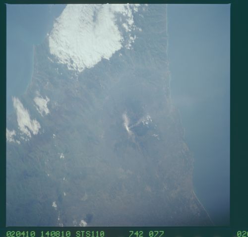
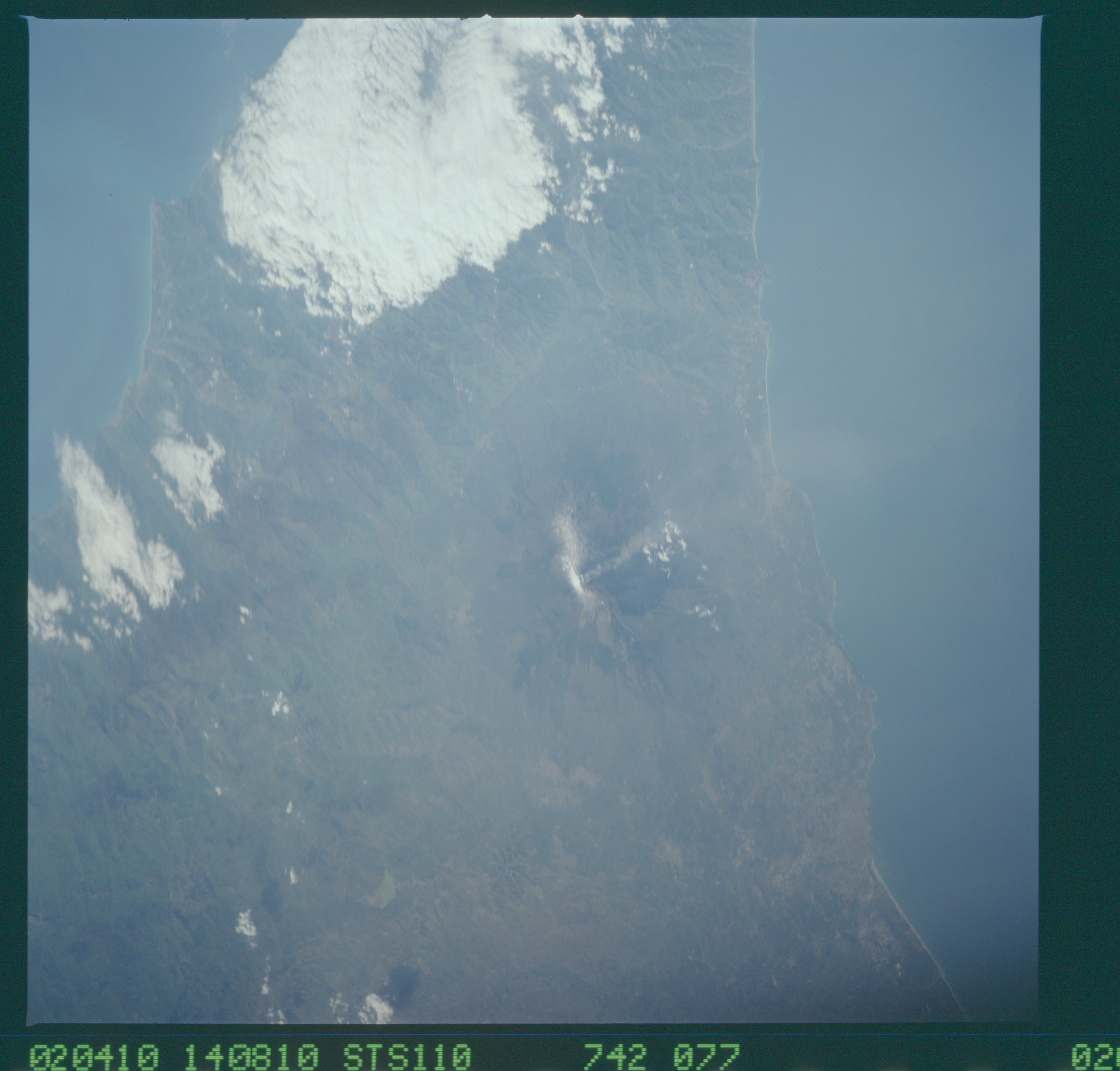
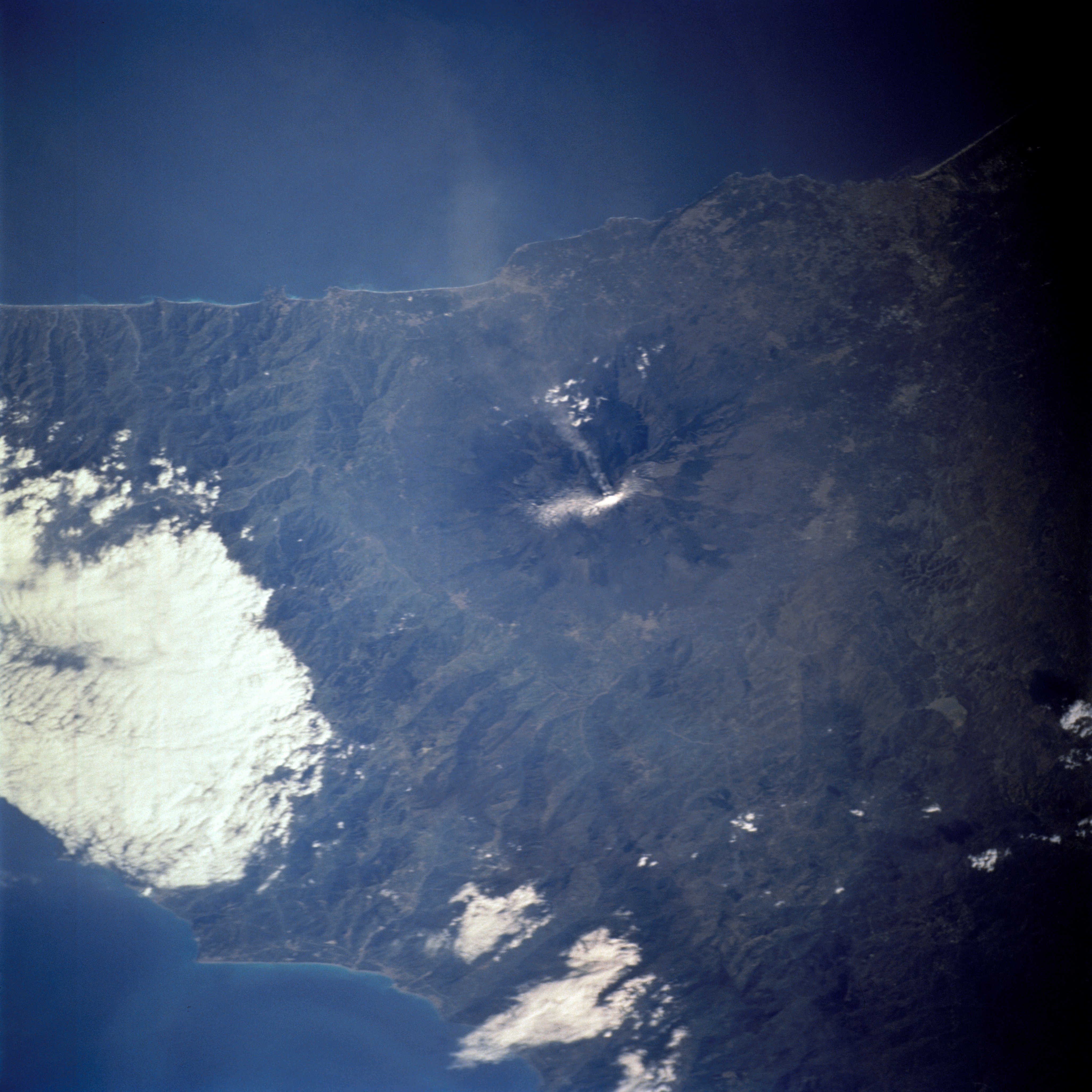
No GeoTIFF is available for this photo.Image Caption: Mt. Etna, Sicily
Mt. Etna can be identified near the center of this near vertical image, primarily by the radial drainage pattern that radiates away from the snow-capped summit. Notice that a small smoke or ash plume is originating from an area near the summit of the volcano. The darker looking areas radiating away from the summit and on the flanks of the volcano show the areas of the more recent lava flows. Mt. Etna is currently one of the most studied and monitored volcanoes in the world. Because of the recent increased level of volcanic activity, many of the communities that encircle the flanks of the Volcano could be threatened by future lava flows. A section of the east-west trending, forested Nebrodi Mountains (partially obscured by clouds in this image) form the northern boundary of the volcano.
Mt. Etna can be identified near the center of this near vertical image, primarily by the radial drainage pattern that radiates away from the snow-capped summit. Notice that a small smoke or ash plume is originating from an area near the summit of the volcano. The darker looking areas radiating away from the summit and on the flanks of the volcano show the areas of the more recent lava flows. Mt. Etna is currently one of the most studied and monitored volcanoes in the world. Because of the recent increased level of volcanic activity, many of the communities that encircle the flanks of the Volcano could be threatened by future lava flows. A section of the east-west trending, forested Nebrodi Mountains (partially obscured by clouds in this image) form the northern boundary of the volcano.
