< STS075-767-73 >
| NASA Photo ID | STS075-767-73 |
| Focal Length | 100mm |
| Date taken | 1996.03.04 |
| Time taken | 04:37:44 GMT |


Cloud masks available for this image:
Spacecraft nadir point: 20.8° N, 113.5° E
Photo center point: 22.5° N, 113.0° E
Photo center point by machine learning:
Photo center point: 22.5° N, 113.0° E
Photo center point by machine learning:
Nadir to Photo Center: North
Spacecraft Altitude: 152 nautical miles (282km)
Country or Geographic Name: | CHINA |
Features: | XI RIVER, LINGDING BAY |
| Features Found Using Machine Learning: | |
Cloud Cover Percentage: | 5 (1-10)% |
Sun Elevation Angle: | 63° |
Sun Azimuth: | 180° |
Camera: | Hasselblad |
Focal Length: | 100mm |
Camera Tilt: | 35 degrees |
Format: | 2443: Kodak Aerochrome 2443, color IR, thin base, EA-5 process thru June 1999, E-6 process afterward |
Film Exposure: | Normal |
| Additional Information | |
| Width | Height | Annotated | Cropped | Purpose | Links |
|---|---|---|---|---|---|
| 5700 pixels | 5900 pixels | No | No | Download Image Download Color Calibration Image for this Image |
|
| 500 pixels | 518 pixels | No | No | Download Image Download Color Calibration Image for this Image |
|
| 640 pixels | 480 pixels | No | No | Download Image |
Download Packaged File
Download a Google Earth KML for this Image
View photo footprint information
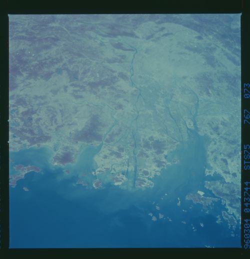
No GeoTIFF is available for this photo.Image Caption: CIR view of the estuary of the Xi Jiang
(Pearl River), south China's main transport artery in the hinterland
of Hong Kong. Guangzhou (Canton_4.1 million) is the urban mass top
right on the Xi Jiang, capital of Guangdong Province (63 million).
Rectangular, manmade extensions to one of the islands in the Hong Kong
Colony can be seen bottom right as a bright patch on the inner coast.
The Hong Kong-Canton corridor has become one of the major
manufacturing regions in modernizing China, with intensiveurbanization
(fastest city growth in the world is in Shenzhen next to Hong Kong)
Eastern Himalaya mountains under snow (center) and the lowland
Brahmaputra River top left. The eastern Himalayas occupy the remote
region where four nations meet: India's Assam region top left, Tibet
top right, China's western province of Yunnan right , and northern
Burma (Myanmar)(bottom)
