< ISS016-E-6986 >

| NASA Photo ID | ISS016-E-6986 |
| Focal Length | 800mm |
| Date taken | 2007.10.26 |
| Time taken | 16:30:01 GMT |
Resolutions offered for this image:
1000 x 652 pixels 540 x 352 pixels 540 x 405 pixels 3032 x 2064 pixels 639 x 435 pixels
1000 x 652 pixels 540 x 352 pixels 540 x 405 pixels 3032 x 2064 pixels 639 x 435 pixels


Spacecraft nadir point: 33.3° N, 105.3° W
Photo center point: 37.8° N, 105.5° W
Photo center point by machine learning:
Photo center point: 37.8° N, 105.5° W
Photo center point by machine learning:
Nadir to Photo Center: North
Spacecraft Altitude: 182 nautical miles (337km)
Country or Geographic Name: | USA-COLORADO |
Features: | GREAT SAND DUNES NATL. PARK |
| Features Found Using Machine Learning: | |
Cloud Cover Percentage: | 10 (1-10)% |
Sun Elevation Angle: | 34° |
Sun Azimuth: | 139° |
Camera: | Kodak DCS760c Electronic Still Camera |
Focal Length: | 800mm |
Camera Tilt: | High Oblique |
Format: | 3060E: 3060 x 2036 pixel CCD, RGBG array |
Film Exposure: | |
| Additional Information | |
| Width | Height | Annotated | Cropped | Purpose | Links |
|---|---|---|---|---|---|
| 1000 pixels | 652 pixels | No | Yes | Earth From Space collection | Download Image |
| 540 pixels | 352 pixels | Yes | Yes | Earth From Space collection | Download Image |
| 540 pixels | 405 pixels | Yes | Yes | NASA's Earth Observatory web site | Download Image |
| 3032 pixels | 2064 pixels | No | No | Download Image | |
| 639 pixels | 435 pixels | No | No | Download Image |
Download Packaged File
Download a Google Earth KML for this Image
View photo footprint information
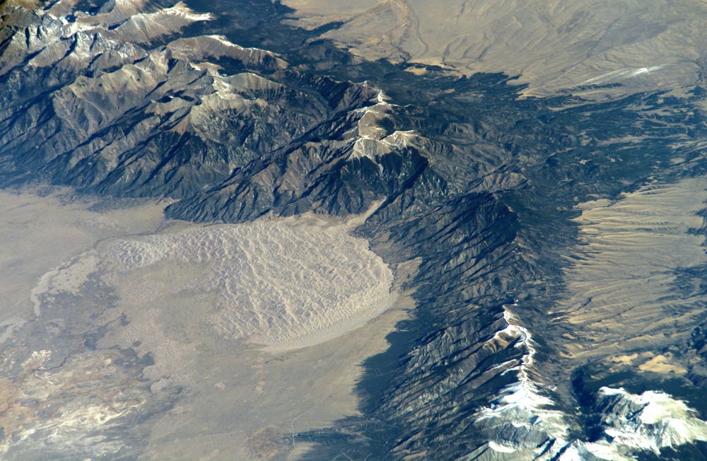
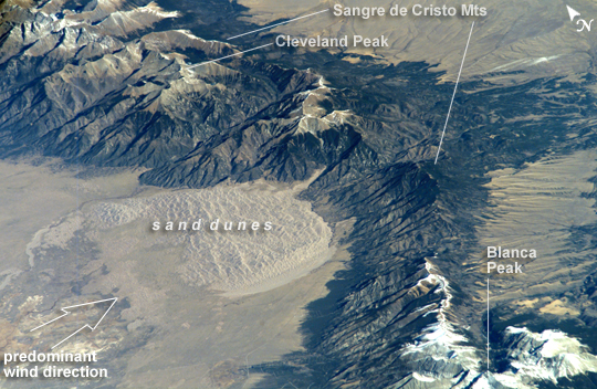
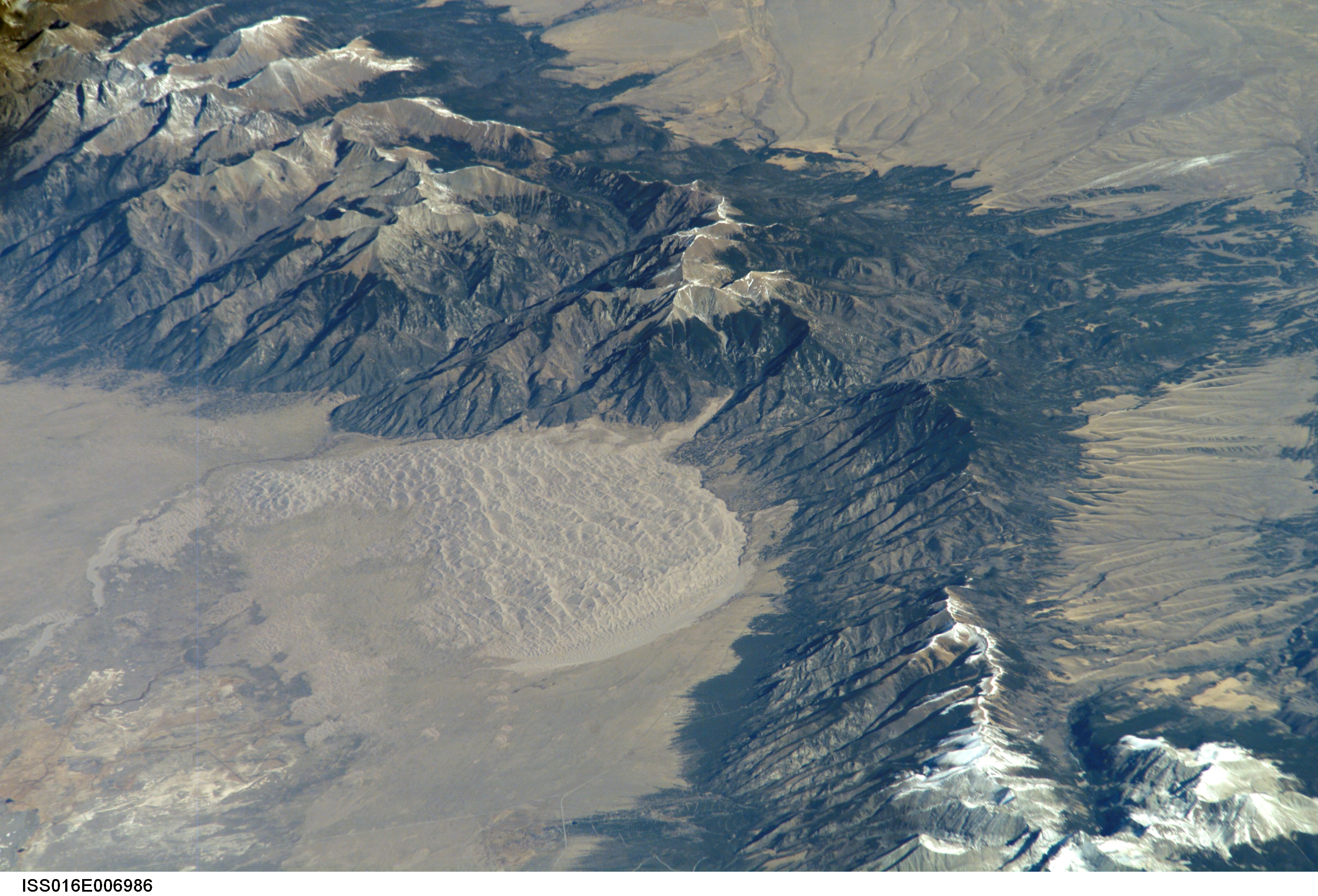
No GeoTIFF is available for this photo.Image Caption: Great Sand Dunes National Park and Preserve, Colorado
The Sangre de Cristo Mountains of south-central Colorado stretch dramatically from top left to lower right of this astronaut photograph. The mountains are outlined by dark green forests at lower elevations and white, snow-capped peaks at the highest elevations. Dun-colored dunes, covering an area of 80 square kilometers, are banked up on the west side of the mountains. These dunes make up the Great Sand Dunes National Park and Preserve. Originally established in 1932 as a National Monument, it was reauthorized as a National Park in 2004. The park contains dunes over 227 meters (about 750 feet) high--among the highest in North America.
Sand grains that make up the dunes are small enough to be moved along by the wind (a process known as saltation), although much of the dune field is now anchored by vegetation. Winds blow predominately to the east, so that sand in the San Luis Valley (part of which appears at image lower left) is driven towards and piled against the Sangre de Cristo Mountains. The sand of the dunes is mostly derived from ancient exposed lakebed sediments--now the floor of the San Luis Valley--that formed by erosion of rocks in the Sangre de Cristo and San Juan Mountains (located to the west). The action of streams and occasional storms today returns some of the impounded sand back to the valley, where the prevailing winds begin the sand's migration to the dune field anew.
The dune field has settled in a low spot along the Sangre de Cristo Mountains; the location of snow cover shows the relative altitudes of the mountains. Areas to the north of the dune field (Cleveland Peak and northward), and to the south around Blanca Peak, are higher than the ridgeline next to the dune field, where almost no snow is visible. Since winds are preferentially channeled over the lower parts of any range (hundreds of meters lower here than ridgelines to north and south), sand grains are carried up to, but not over, the low point of the range.
