< STS085-505-62 >
| NASA Photo ID | STS085-505-62 |
| Focal Length | 250mm |
| Date taken | 1997.08.__ |
| Time taken | GMT |

Cloud masks available for this image:
Spacecraft nadir point:
Photo center point: 40.5° N, 27.5° E
Photo center point by machine learning:
Photo center point: 40.5° N, 27.5° E
Photo center point by machine learning:
Nadir to Photo Center:
Spacecraft Altitude: nautical miles (0km)
Country or Geographic Name: | TURKEY |
Features: | KUS LAKE, MARMARA SEA |
| Features Found Using Machine Learning: | |
Cloud Cover Percentage: | 5 (1-10)% |
Sun Elevation Angle: | ° |
Sun Azimuth: | ° |
Camera: | Linhof |
Focal Length: | 250mm |
Camera Tilt: | Low Oblique |
Format: | 5046: Kodak, natural color positive, Lumiere 100/5046, ASA 100, standard base |
Film Exposure: | Normal |
| Additional Information | |
| Width | Height | Annotated | Cropped | Purpose | Links |
|---|---|---|---|---|---|
| 4096 pixels | 5248 pixels | No | No | Earth From Space collection | Download Image |
| 499 pixels | 640 pixels | No | No | Earth From Space collection | Download Image |
Download Packaged File
Download a Google Earth KML for this Image
View photo footprint information
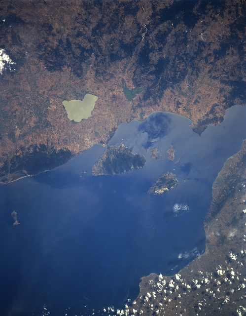
No GeoTIFF is available for this photo.Image Caption: STS085-505-062 Sea of Marmara, Turkey August 1997
The small inland Sea of Marmara (The Sea of Marble), between the European (bottom) Turkey and Asiatic (upper) Turkey, can be seen in this south-southwest-looking view. The sea is 170 miles (275 km) long and 50 miles (80 km) at its maximum width. The Sea of Marmara covers an area of 4,300 square miles (11,800 square km). Its maximum depth is about 4,500 feet (1370 meters) and there are no strong currents. The tidal range is minimum. The Sea of Marmara is a strategically important sea route for the shipping fleets of the world that travel between the Black Sea and the Mediterranean Sea. Numerous islands are situated in the Sea of Marmara, including the island of Marmara (lower right quadrant) where marble and alabaster are quarried.
The small inland Sea of Marmara (The Sea of Marble), between the European (bottom) Turkey and Asiatic (upper) Turkey, can be seen in this south-southwest-looking view. The sea is 170 miles (275 km) long and 50 miles (80 km) at its maximum width. The Sea of Marmara covers an area of 4,300 square miles (11,800 square km). Its maximum depth is about 4,500 feet (1370 meters) and there are no strong currents. The tidal range is minimum. The Sea of Marmara is a strategically important sea route for the shipping fleets of the world that travel between the Black Sea and the Mediterranean Sea. Numerous islands are situated in the Sea of Marmara, including the island of Marmara (lower right quadrant) where marble and alabaster are quarried.
