< STS085-503-61 >

| NASA Photo ID | STS085-503-61 |
| Focal Length | 90mm |
| Date taken | 1997.08.__ |
| Time taken | GMT |

Cloud masks available for this image:
Spacecraft nadir point:
Photo center point: 44.5° N, 79.0° E
Photo center point by machine learning:
Photo center point: 44.5° N, 79.0° E
Photo center point by machine learning:
Nadir to Photo Center:
Spacecraft Altitude: nautical miles (0km)
Country or Geographic Name: | KAZAKHSTAN |
Features: | PAN-LAKE ALAKOL, DUST, ARM |
| Features Found Using Machine Learning: | |
Cloud Cover Percentage: | 25 (11-25)% |
Sun Elevation Angle: | ° |
Sun Azimuth: | ° |
Camera: | Linhof |
Focal Length: | 90mm |
Camera Tilt: | High Oblique |
Format: | 5046: Kodak, natural color positive, Lumiere 100/5046, ASA 100, standard base |
Film Exposure: | Normal |
| Additional Information | |
| Width | Height | Annotated | Cropped | Purpose | Links |
|---|---|---|---|---|---|
| 540 pixels | 416 pixels | Photographic Highlights | Download Image | ||
| 802 pixels | 640 pixels | No | No | Photographic Highlights | Download Image |
| 640 pixels | 493 pixels | Download Image |
Download Packaged File
Download a Google Earth KML for this Image
View photo footprint information
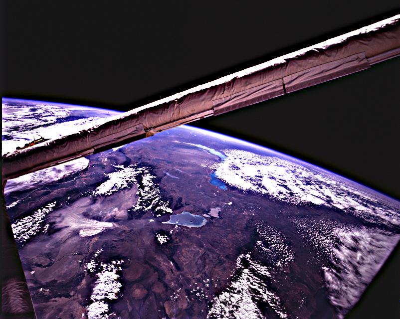
No GeoTIFF is available for this photo.Image Caption: Lakes Balkhash and Alakol', southern uplands of Kazakhstan, central Asia. The long (600 km) arc of Lake
Balkhash occupies the center of this clear WNW view of the southern Kazakh Uplands, Kazakhstan and
westernmost Dzungarian Basin in the autonomous region of Xinjiang Uygur, China. The capitol city of
Alma-Ata, Kazakhstan is out of sight behind the boom. The Dzungarian Gate is the straight, fault-bounded
valley dropped down within t he Dzhungarskiy Alatau Range; lowest elevation on the valley floor is about
1,500 ft, whereas peaks of the range reach 15,000 ft on the west and about 10,000 ft on the east of the
valley. Lake Ebinur is the bright area beneath the dust plume (left center); north winds funneled through the
Dzungarian Gate have picked up sediment from dry lakebeds at the north end. The Ili River flows
westward, parallel to the Dzhungarskiy Alatau Range, through Kapchagay Lake (partially visible beneath
boom), then northwest across the delta plain and into Lake Balkhash. The Karatal River heads in the
Dzhungarskiy Alatau mountains and flows north into Balkhash.
