< STS095-743-59 >
| NASA Photo ID | STS095-743-59 |
| Focal Length | 40mm |
| Date taken | 1998.10.31 |
| Time taken | 19:05:12 GMT |

Cloud masks available for this image:
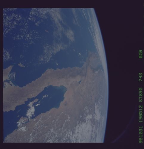
Spacecraft nadir point: 26.7° N, 113.9° W
Photo center point: 32.0° N, 116.0° W
Photo center point by machine learning:
Photo center point: 32.0° N, 116.0° W
Photo center point by machine learning:
Nadir to Photo Center: North
Spacecraft Altitude: 294 nautical miles (544km)
Country or Geographic Name: | MEXICO |
Features: | PAN-BAJA PEN, GREAT BASIN |
| Features Found Using Machine Learning: | |
Cloud Cover Percentage: | 15 (11-25)% |
Sun Elevation Angle: | 49° |
Sun Azimuth: | 175° |
Camera: | Hasselblad |
Focal Length: | 40mm |
Camera Tilt: | High Oblique |
Format: | 5069: Kodak Elite 100S, E6 Reversal, Replaces Lumiere, Warmer in tone vs. Lumiere |
Film Exposure: | Normal |
| Additional Information | |
| Width | Height | Annotated | Cropped | Purpose | Links |
|---|---|---|---|---|---|
| 5700 pixels | 5900 pixels | No | No | Download Image Download Color Calibration Image for this Image |
|
| 483 pixels | 500 pixels | No | No | Download Image Download Color Calibration Image for this Image |
Download Packaged File
Download a Google Earth KML for this Image
View photo footprint information
No GeoTIFF is available for this photo.Image Caption: California, Baja California. This northward view embraces the spreading center of the Gulf of California and its junction with the San Andreas transform fault system north and east of Los Angeles. The Imperial Valley and Salton Sea are products of spreading in the Gulf, whereas the Channel Islands and Point Arguello are part of the transform fault boundary.
