< NM23-773-56 >
| NASA Photo ID | NM23-773-56 |
| Focal Length | 250mm |
| Date taken | 1997.03.20 |
| Time taken | GMT |
Resolutions offered for this image:
4060 x 4060 pixels 639 x 639 pixels 5700 x 6000 pixels 500 x 526 pixels
4060 x 4060 pixels 639 x 639 pixels 5700 x 6000 pixels 500 x 526 pixels


Cloud masks available for this image:
Spacecraft nadir point:
Photo center point: 27.5° S, 57.5° W
Photo center point by machine learning:
Photo center point: 27.5° S, 57.5° W
Photo center point by machine learning:
Nadir to Photo Center:
Spacecraft Altitude: nautical miles (0km)
Country or Geographic Name: | PARAGUAY |
Features: | RIO PARANA, SMOKE |
| Features Found Using Machine Learning: | |
Cloud Cover Percentage: | 5 (1-10)% |
Sun Elevation Angle: | ° |
Sun Azimuth: | ° |
Camera: | Hasselblad |
Focal Length: | 250mm |
Camera Tilt: | Low Oblique |
Format: | 2443: Kodak Aerochrome 2443, color IR, thin base, EA-5 process thru June 1999, E-6 process afterward |
Film Exposure: | Normal |
| Additional Information | |
| Width | Height | Annotated | Cropped | Purpose | Links |
|---|---|---|---|---|---|
| 4060 pixels | 4060 pixels | No | No | Earth From Space collection | Download Image |
| 639 pixels | 639 pixels | No | No | Earth From Space collection | Download Image |
| 5700 pixels | 6000 pixels | No | No | Download Image | |
| 500 pixels | 526 pixels | No | No | Download Image |
Download Packaged File
Download a Google Earth KML for this Image
View photo footprint information
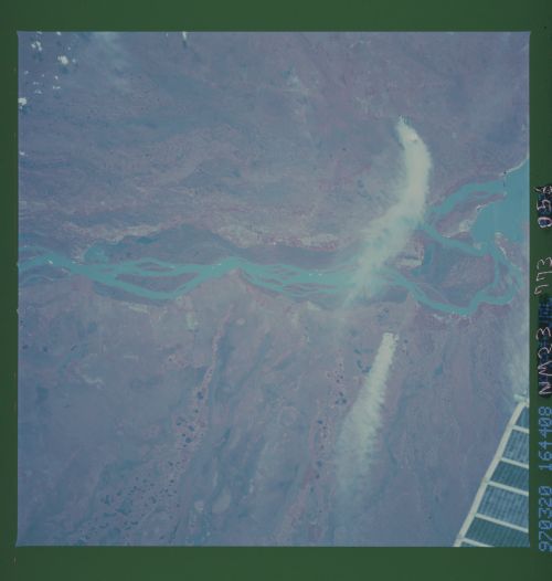
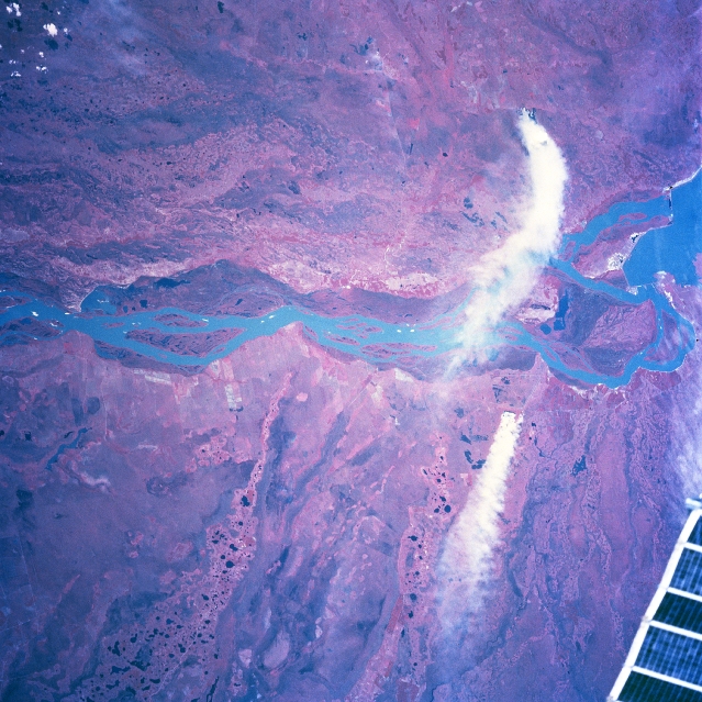
No GeoTIFF is available for this photo.Image Caption: NM23-773-056 Rio Parana, Argentina/Paraguay Winter/Spring 1997
For geographic reference the Yacyreta-Apipe Dams are visible on the Rio Parana near the eastern edge of the picture (right margin). The Rio Parana is the border between Paraguay (top) and Argentina (bottom). In addition to the well-defined, natural floodplain of the Rio Parana (darker feature, mainly on the Paraguay side of the river), the entire scene shows a complex hydrologic pattern. Complicated and intricate drainage patterns can be observed on both sides of the river. It appears that the Rio Parana has repeatedly made significant course changes. South of the river, well defined, older drainage channels, primarily aligned in a northeast-southwest pattern, can be traced across this flat, swampy terrain. North of the Rio Parana in Paraguay the older drainage channels are aligned more east-west. Two large smoke plumes (white features-one originating in Paraguay, the other in Argentina) appear on the right side. A small section (solar array truss) of the Space Station Mir is visible in the lower right corner of the picture.
For geographic reference the Yacyreta-Apipe Dams are visible on the Rio Parana near the eastern edge of the picture (right margin). The Rio Parana is the border between Paraguay (top) and Argentina (bottom). In addition to the well-defined, natural floodplain of the Rio Parana (darker feature, mainly on the Paraguay side of the river), the entire scene shows a complex hydrologic pattern. Complicated and intricate drainage patterns can be observed on both sides of the river. It appears that the Rio Parana has repeatedly made significant course changes. South of the river, well defined, older drainage channels, primarily aligned in a northeast-southwest pattern, can be traced across this flat, swampy terrain. North of the Rio Parana in Paraguay the older drainage channels are aligned more east-west. Two large smoke plumes (white features-one originating in Paraguay, the other in Argentina) appear on the right side. A small section (solar array truss) of the Space Station Mir is visible in the lower right corner of the picture.
