< ISS021-E-5555 >
| NASA Photo ID | ISS021-E-5555 |
| Focal Length | 400mm |
| Date taken | 2009.10.11 |
| Time taken | 18:16:09 GMT |
Resolutions offered for this image:
1000 x 664 pixels 540 x 359 pixels 720 x 720 pixels 3072 x 2098 pixels 640 x 437 pixels
1000 x 664 pixels 540 x 359 pixels 720 x 720 pixels 3072 x 2098 pixels 640 x 437 pixels


Spacecraft nadir point: 17.3° N, 60.4° W
Photo center point: 16.7° N, 62.2° W
Photo center point by machine learning:
Photo center point: 16.7° N, 62.2° W
Photo center point by machine learning:
Nadir to Photo Center: West
Spacecraft Altitude: 183 nautical miles (339km)
Country or Geographic Name: | LESSER ANTILLES |
Features: | MONTSERRAT I., SOUFRIERE HILLS VOLCANO, PLUME, SUNGLINT |
| Features Found Using Machine Learning: | |
Cloud Cover Percentage: | 10 (1-10)% |
Sun Elevation Angle: | 46° |
Sun Azimuth: | 239° |
Camera: | Nikon D2Xs Electronic Still Camera |
Focal Length: | 400mm |
Camera Tilt: | 32 degrees |
Format: | 4288E: 4288 x 2848 pixel CMOS sensor, RGBG imager color filter |
Film Exposure: | |
| Additional Information | |
| Width | Height | Annotated | Cropped | Purpose | Links |
|---|---|---|---|---|---|
| 1000 pixels | 664 pixels | No | Yes | Earth From Space collection | Download Image |
| 540 pixels | 359 pixels | Yes | Yes | Earth From Space collection | Download Image |
| 720 pixels | 720 pixels | Yes | Yes | NASA's Earth Observatory web site | Download Image |
| 3072 pixels | 2098 pixels | No | No | Download Image | |
| 640 pixels | 437 pixels | No | No | Download Image |
Download Packaged File
Download a Google Earth KML for this Image
View photo footprint information
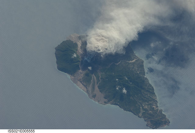
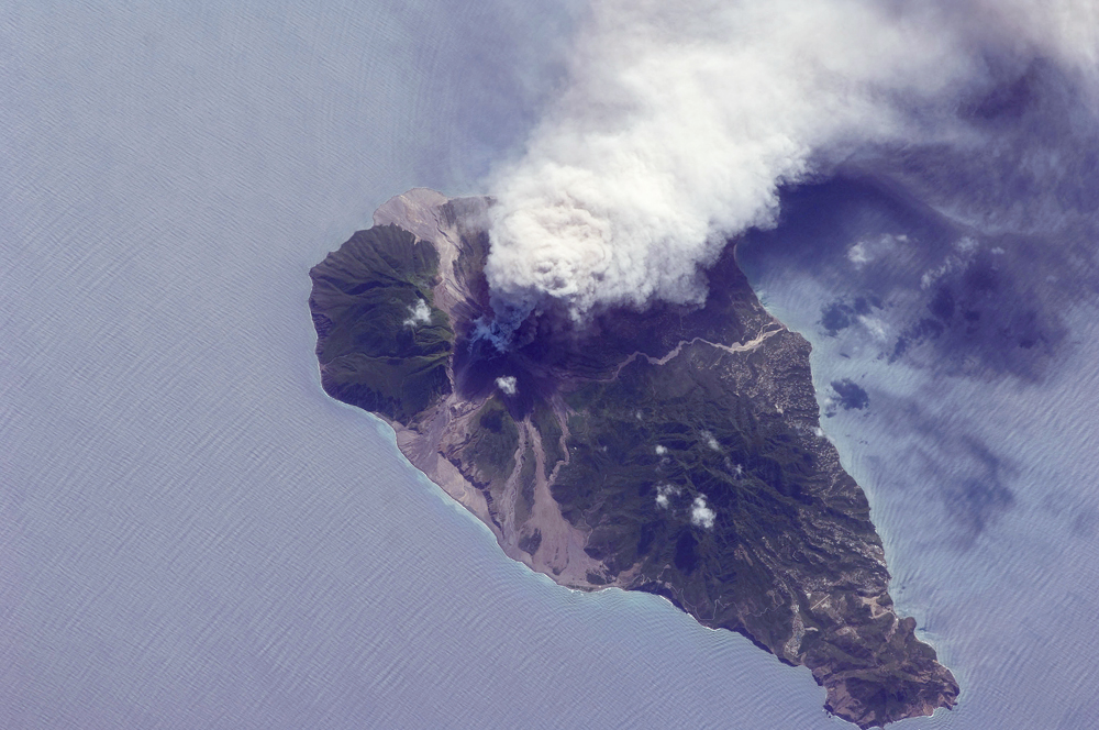
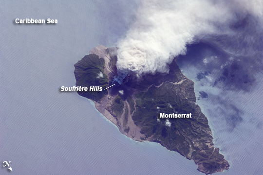
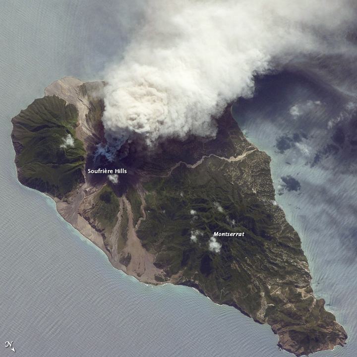
No GeoTIFF is available for this photo.Image Caption: Ash and Steam Plume, Soufriere Hills Volcano, Montserrat
The Soufriere Hills, a volcano on the island of Montserrat, in the Lesser Antilles island chain in the Caribbean Sea, has been active since 1995. The most recent eruptive phase of the volcano began with a short swarm of volcano-tectonic earthquakes--earthquakes thought to be caused by movement of magma beneath a volcano--on October 4, 2009, followed by a series of ash-venting events that have continued through October 13, 2009. These venting events create plumes that can deposit ash at significant distances from the volcano. In addition to ash plumes, pyroclastic flows and lava dome growth have been reported as part of the current eruptive activity.
This oblique astronaut photograph from the International Space Station (ISS) captures a white-to-gray ash and steam plume extending westwards from the volcano on October 11, 2009. Oblique images are taken by astronauts looking out from the ISS at an angle, rather than looking straight downward toward the Earth (a perspective called a nadir view), as is common with most remotely sensed data from satellites. An oblique view gives the scene a more three-dimension quality, and provides a look at the vertical structure of the volcanic plume.
While much of the island is covered in green vegetation, gray deposits that include pyroclastic flows and volcanic mudflows (lahars) are visible extending from the volcano toward the coastline. When compared to its extent in earlier views, the volcanic debris has filled in more of the eastern coastline. Urban areas are visible in the northern and western portions of the island; they are recognizable by linear street patterns and the presence of bright building rooftops. The silver-gray appearance of the Caribbean Sea surface is due to sunglint, which is the mirror-like reflection of sunlight off the water surface back towards the handheld camera onboard the ISS. The sunglint highlights surface wave patterns around the island.
