< ISS035-E-5438 >
| NASA Photo ID | ISS035-E-5438 |
| Focal Length | 400mm |
| Date taken | 2013.03.16 |
| Time taken | 11:56:50 GMT |
Resolutions offered for this image:
1000 x 665 pixels 540 x 359 pixels 1440 x 960 pixels 720 x 480 pixels 4256 x 2832 pixels 640 x 426 pixels
1000 x 665 pixels 540 x 359 pixels 1440 x 960 pixels 720 x 480 pixels 4256 x 2832 pixels 640 x 426 pixels

Cloud masks available for this image:
Spacecraft nadir point: 34.0° N, 112.9° W
Photo center point: 33.5° N, 112.2° W
Photo center point by machine learning: 33.55° N, 112.21° W
Photo center point: 33.5° N, 112.2° W
Photo center point by machine learning: 33.55° N, 112.21° W
Nadir to Photo Center: Southeast
Spacecraft Altitude: 214 nautical miles (396km)

Country or Geographic Name: | USA-ARIZONA |
Features: | PHOENIX AT NIGHT, GLENDALE AT NIGHT, PEORIA AT NIGHT, SALT RIVER VALLEY |
| Features Found Using Machine Learning: | PHOENIX |
Cloud Cover Percentage: | 10 (1-10)% |
Sun Elevation Angle: | -22° |
Sun Azimuth: | 76° |
Camera: | Nikon D3S Electronic Still Camera |
Focal Length: | 400mm |
Camera Tilt: | 14 degrees |
Format: | 4256E: 4256 x 2832 pixel CMOS sensor, 36.0mm x 23.9mm, total pixels: 12.87 million, Nikon FX format |
Film Exposure: | |
| Additional Information | |
| Width | Height | Annotated | Cropped | Purpose | Links |
|---|---|---|---|---|---|
| 1000 pixels | 665 pixels | No | Yes | Earth From Space collection | Download Image |
| 540 pixels | 359 pixels | Yes | Yes | Earth From Space collection | Download Image |
| 1440 pixels | 960 pixels | No | Yes | NASA's Earth Observatory web site | Download Image |
| 720 pixels | 480 pixels | Yes | No | NASA's Earth Observatory web site | Download Image |
| 4256 pixels | 2832 pixels | No | No | Download Image | |
| 640 pixels | 426 pixels | No | No | Download Image |
Download Packaged File
Download a Google Earth KML for this Image
View photo footprint information
Download a GeoTIFF for this photo
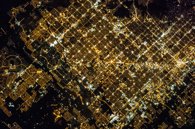
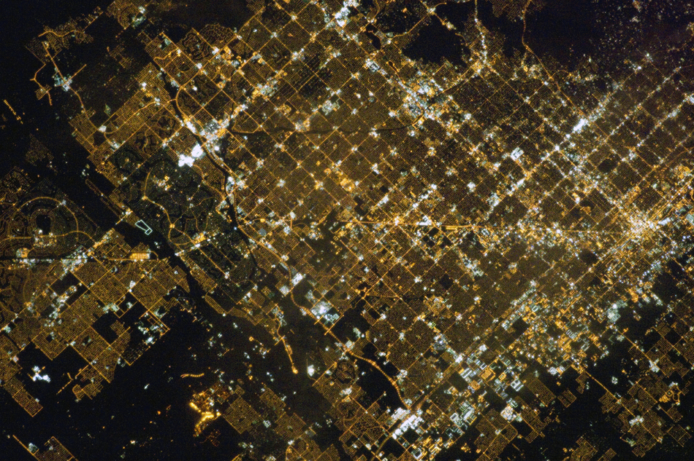
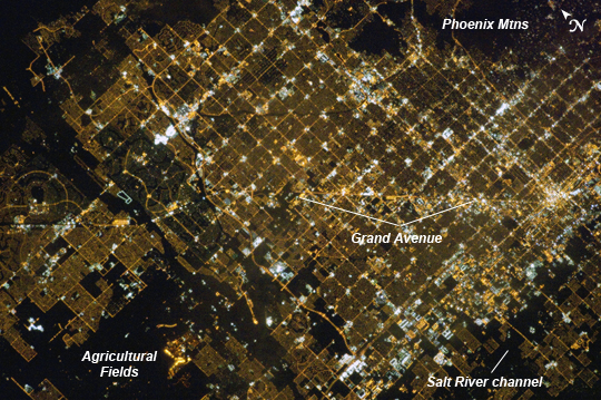
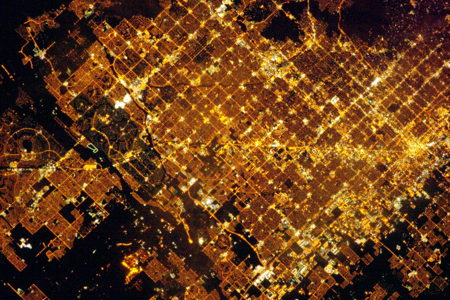
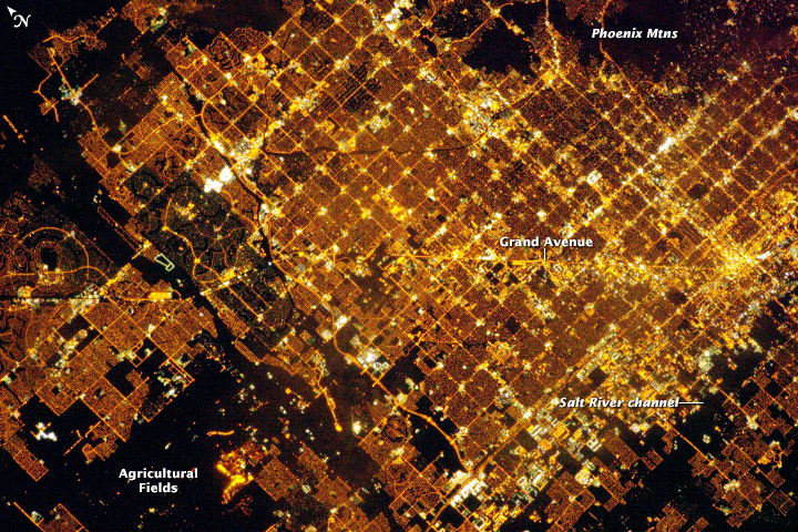
Image Caption: Phoenix, AZ Metropolitan Area at Night
Like many large urban areas of the central and western United States, the Phoenix, AZ metropolitan area is laid out along a regular grid of city blocks and streets. While visible during the day this grid is most evident at night, when the pattern of street lighting is clearly visible from above - in the case of this astronaut photograph, from the low Earth orbit vantage point of the International Space Station. The urban grid form encourages growth of a city outwards along its borders, by providing optimal access to new real estate. Fueled by the adoption of widespread personal automobile use during the 20th century, the Phoenix metropolitan area today includes 25 other municipalities (many of them largely suburban and residential in character) linked by a network of surface streets and freeways.
This astronaut photograph includes parts of several cities in the metro area including Phoenix (image right), Glendale (image center), and Peoria (image left). While the major street grid is oriented north-south, the northwest-southeast oriented Grand Avenue cuts across it at image center. Grand Avenue is a major transportation corridor through the western metropolitan area; the lighting patterns of large industrial and commercial properties are visible along its length. Other brightly lit properties include large shopping centers, strip centers, and gas stations which tend to be located at the intersections of north-south and east-west trending streets.
While much of the land area highlighted in this image is urbanized, there are several noticeably dark areas. The Phoenix Mountains at image upper right are largely public park and recreational land. To the west (image lower left), agricultural fields provide a sharp contrast to the lit streets of neighboring residential developments. The Salt River channel appears as a dark ribbon within the urban grid at image lower right.
