< STS110-738-52 >
| NASA Photo ID | STS110-738-52 |
| Focal Length | 110mm |
| Date taken | 2002.04.13 |
| Time taken | 11:15:14 GMT |
Resolutions offered for this image:
4600 x 4400 pixels 768 x 768 pixels 875 x 836 pixels 540 x 540 pixels 4600 x 4400 pixels 500 x 478 pixels 4000 x 4000 pixels 639 x 639 pixels
4600 x 4400 pixels 768 x 768 pixels 875 x 836 pixels 540 x 540 pixels 4600 x 4400 pixels 500 x 478 pixels 4000 x 4000 pixels 639 x 639 pixels


Cloud masks available for this image:
Spacecraft nadir point: 28.7° N, 33.3° E
Photo center point: 29.0° N, 33.0° E
Photo center point by machine learning:
Photo center point: 29.0° N, 33.0° E
Photo center point by machine learning:
Nadir to Photo Center: Northwest
Spacecraft Altitude: 205 nautical miles (380km)
Country or Geographic Name: | EGYPT |
Features: | GULF OF SUEZ, SINAI PEN. |
| Features Found Using Machine Learning: | |
Cloud Cover Percentage: | 10 (1-10)% |
Sun Elevation Angle: | 62° |
Sun Azimuth: | 231° |
Camera: | Hasselblad |
Focal Length: | 110mm |
Camera Tilt: | 7 degrees |
Format: | 5069: Kodak Elite 100S, E6 Reversal, Replaces Lumiere, Warmer in tone vs. Lumiere |
Film Exposure: | |
| Additional Information | |
| Width | Height | Annotated | Cropped | Purpose | Links |
|---|---|---|---|---|---|
| 4600 pixels | 4400 pixels | No | No | Photographic Highlights | Download Image |
| 768 pixels | 768 pixels | Photographic Highlights | Download Image | ||
| 875 pixels | 836 pixels | No | No | Photographic Highlights | Download Image |
| 540 pixels | 540 pixels | Photographic Highlights | Download Image | ||
| 4600 pixels | 4400 pixels | No | No | Download Image | |
| 500 pixels | 478 pixels | No | No | Download Image | |
| 4000 pixels | 4000 pixels | Public Affairs Office (PAO) | Download Image | ||
| 639 pixels | 639 pixels | Photographic Highlights | Download Image |
Download Packaged File
Download a Google Earth KML for this Image
View photo footprint information
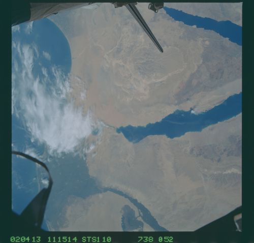
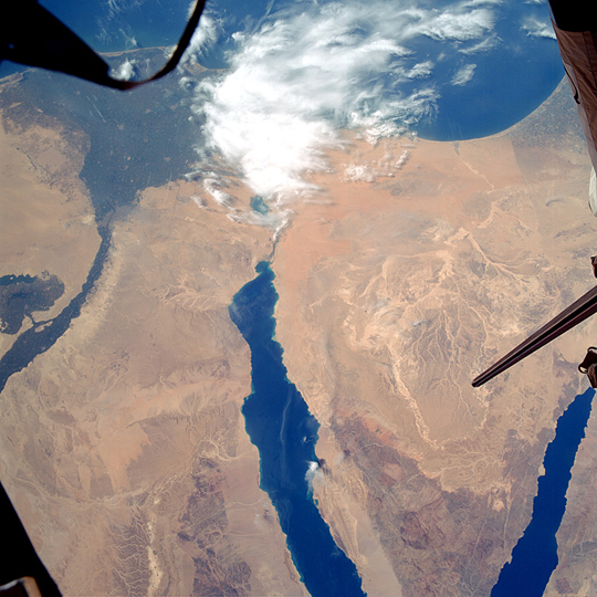
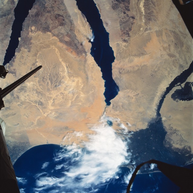
No GeoTIFF is available for this photo.Image Caption: Gulf of Suez, Sinai Peninsula, Egypt April 2002
FOR PAO---Recommend that this image be rotated 180 degrees. Caption written to rotated image.
The major portion of the 180 mile (290 km) long Gulf of Suez (center of the image) can be seen in this north-looking view. The Gulf of Suez is one of the most important water transportation routes in the world connecting the Mediterranean Sea (upper portion of the image) through the Suez Canal (mostly covered by clouds) with the Red Sea (not visible on the image) and the Indian Ocean. To the gulf's right (east), the rugged landscape of the Sinai Peninsula can be seen. The 100 mile (160 km) long Gulf of Aqaba, which is part of the Great Rift Valley of Eastern Africa, is discernible at the lower right of the image. Near the upper right portion of the image, a distinct line marking the border between Israel and Egypt can be seen. To the left (west) of the Gulf of Suez, are the Western Desert and the Nile River Valley and Delta of eastern Egypt. The tail of the Space Shuttle is discernible at the right center of the image.
