< STS056-97-52 >
| NASA Photo ID | STS056-97-52 |
| Focal Length | 250mm |
| Date taken | 1993.04.14 |
| Time taken | 12:41:35 GMT |
Resolutions offered for this image:
3904 x 3904 pixels 639 x 639 pixels 5700 x 6000 pixels 500 x 526 pixels 640 x 480 pixels
3904 x 3904 pixels 639 x 639 pixels 5700 x 6000 pixels 500 x 526 pixels 640 x 480 pixels


Cloud masks available for this image:
Spacecraft nadir point: 25.2° N, 81.0° W
Photo center point: 25.5° N, 80.5° W
Photo center point by machine learning:
Photo center point: 25.5° N, 80.5° W
Photo center point by machine learning:
Nadir to Photo Center: Northeast
Spacecraft Altitude: 161 nautical miles (298km)
Country or Geographic Name: | USA-FLORIDA |
Features: | CITY OF MIAMI |
| Features Found Using Machine Learning: | |
Cloud Cover Percentage: | 0 (no clouds present) |
Sun Elevation Angle: | 21° |
Sun Azimuth: | 89° |
Camera: | Hasselblad |
Focal Length: | 250mm |
Camera Tilt: | 12 degrees |
Format: | 5017: Kodak, natural color positive, Ektachrome, X Professional, ASA 64, standard base |
Film Exposure: | Normal |
| Additional Information | |
| Width | Height | Annotated | Cropped | Purpose | Links |
|---|---|---|---|---|---|
| 3904 pixels | 3904 pixels | No | No | Earth From Space collection | Download Image |
| 639 pixels | 639 pixels | No | No | Earth From Space collection | Download Image |
| 5700 pixels | 6000 pixels | No | No | Download Image Download Color Calibration Image for this Image |
|
| 500 pixels | 526 pixels | No | No | Download Image Download Color Calibration Image for this Image |
|
| 640 pixels | 480 pixels | No | No | Download Image |
Download Packaged File
Download a Google Earth KML for this Image
View photo footprint information
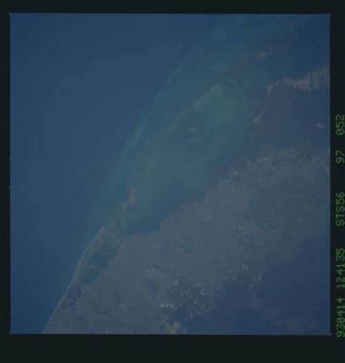
No GeoTIFF is available for this photo.Image Caption: STS056-097-052 Miami, Florida, U.S.A. April 1993
The dark blue Straits of Florida (the north-flowing Gulf Stream) with water depths exceeding 1000 feet (305 meters) contrast with the lighter blues of Biscayne Bay where water depths of 6 to 10 feet (2 to 3 meters) are common. At this scale few features of Miami are discernible--the runway and apron of Homestead Air Force Base south of city and large rectangular water-filled pits created by the excavation of limestone (bottom center).
The dark blue Straits of Florida (the north-flowing Gulf Stream) with water depths exceeding 1000 feet (305 meters) contrast with the lighter blues of Biscayne Bay where water depths of 6 to 10 feet (2 to 3 meters) are common. At this scale few features of Miami are discernible--the runway and apron of Homestead Air Force Base south of city and large rectangular water-filled pits created by the excavation of limestone (bottom center).
