< STS090-750-49 >

| NASA Photo ID | STS090-750-49 |
| Focal Length | 250mm |
| Date taken | 1998.05.02 |
| Time taken | 15:54:44 GMT |
Resolutions offered for this image:
4085 x 4096 pixels 638 x 640 pixels 5700 x 5900 pixels 483 x 500 pixels 489 x 508 pixels 479 x 479 pixels
4085 x 4096 pixels 638 x 640 pixels 5700 x 5900 pixels 483 x 500 pixels 489 x 508 pixels 479 x 479 pixels

Cloud masks available for this image:
Spacecraft nadir point: 39.1° N, 112.8° W
Photo center point: 35.5° N, 111.5° W
Photo center point by machine learning:
Photo center point: 35.5° N, 111.5° W
Photo center point by machine learning:
Nadir to Photo Center: South
Spacecraft Altitude: 133 nautical miles (246km)
Country or Geographic Name: | USA-ARIZONA |
Features: | HUMPHREYS PEAK, CRATER |
| Features Found Using Machine Learning: | |
Cloud Cover Percentage: | 5 (1-10)% |
Sun Elevation Angle: | 38° |
Sun Azimuth: | 101° |
Camera: | Hasselblad |
Focal Length: | 250mm |
Camera Tilt: | Low Oblique |
Format: | 5069: Kodak Elite 100S, E6 Reversal, Replaces Lumiere, Warmer in tone vs. Lumiere |
Film Exposure: | Normal |
| Additional Information | |
| Width | Height | Annotated | Cropped | Purpose | Links |
|---|---|---|---|---|---|
| 4085 pixels | 4096 pixels | No | No | Earth From Space collection | Download Image |
| 638 pixels | 640 pixels | No | No | Earth From Space collection | Download Image |
| 5700 pixels | 5900 pixels | No | No | Download Image | |
| 483 pixels | 500 pixels | No | No | Download Image | |
| 489 pixels | 508 pixels | No | No | Download Image | |
| 479 pixels | 479 pixels | Download Image |
Download Packaged File
Download a Google Earth KML for this Image
View photo footprint information
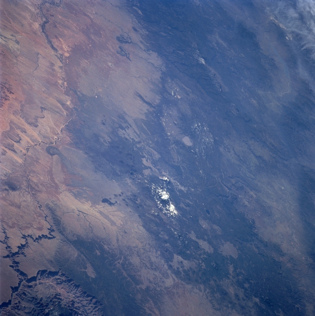
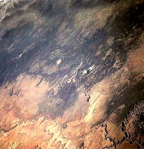
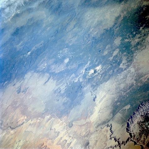
No GeoTIFF is available for this photo.Image Caption: STS090-750-049 San Francisco Mountains, Arizona, USA April 1998
The San Francisco Mountains (volcanic field), including snow capped Humphrey's Peak (12,633 feet--3851 meters) the highest point in Arizona, is visible near the center of the picture. The city of Flagstaff (not distinctive in this wide view) is located immediately south of Humphrey's Peak. The lighter colored, oval shaped feature southeast of Humphrey's Peak is Mormon Lake. Southeast of Mormon Lake, part of the Mogollon Plateau can be seen as it extends in a general east-west direction. Northeast of Humphrey's Peak a section of the Painted Desert of north central Arizona is visible. The intermittently flowing Little Colorado River and its deeply incised stream channel can be traced across this arid environment as it heads northwest, eventually entering the Colorado River at the eastern end of the Grand Canyon (northern or lower right corner of the image).
The San Francisco Mountains (volcanic field), including snow capped Humphrey's Peak (12,633 feet--3851 meters) the highest point in Arizona, is visible near the center of the picture. The city of Flagstaff (not distinctive in this wide view) is located immediately south of Humphrey's Peak. The lighter colored, oval shaped feature southeast of Humphrey's Peak is Mormon Lake. Southeast of Mormon Lake, part of the Mogollon Plateau can be seen as it extends in a general east-west direction. Northeast of Humphrey's Peak a section of the Painted Desert of north central Arizona is visible. The intermittently flowing Little Colorado River and its deeply incised stream channel can be traced across this arid environment as it heads northwest, eventually entering the Colorado River at the eastern end of the Grand Canyon (northern or lower right corner of the image).
