< STS042-79-46 >
| NASA Photo ID | STS042-79-46 |
| Focal Length | 100mm |
| Date taken | 1992.01.28 |
| Time taken | 00:48:12 GMT |
Cloud masks available for this image:
Spacecraft nadir point: 56.8° N, 161.9° E
Photo center point: 56.0° N, 160.0° E
Photo center point by machine learning:
Photo center point: 56.0° N, 160.0° E
Photo center point by machine learning:
Nadir to Photo Center: West
Spacecraft Altitude: 166 nautical miles (307km)Body: Earth
Camera: | Hasselblad |
Focal Length: | 100mm |
Camera Tilt: | Near Vertical |
Format: | 5017: Kodak, natural color positive, Ektachrome, X Professional, ASA 64, standard base |
Film Exposure: | Normal |
| Additional Information | |
| Width | Height | Annotated | Cropped | Purpose | Links |
|---|---|---|---|---|---|
| 5700 pixels | 6000 pixels | No | No | Download Image | |
| 500 pixels | 526 pixels | No | No | Download Image | |
| 640 pixels | 480 pixels | No | No | Download Image |
Download Packaged File
Download a Google Earth KML for this Image
View photo footprint information
No GeoTIFF is available for this photo.Image Caption:
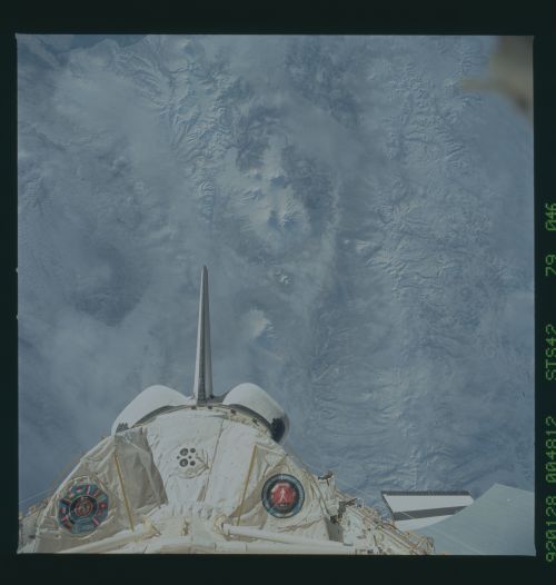
STS042-79-046: Kamchatka Peninsula The northernmost vol-
canoes on Kamchatka, Shiveluch (to the north) and Kluchevskaya
and Tolbachinsky (to the south) are some of KamchatkaUs most ac-
tive. This is a wide-angle photograph of the northern volcanic
province. For scale, the distance between Kluchevskaya (the
large, conical volcano with a close neighbor in the center of the
cluster of volcanoes) and Tolbachinsky (the volcano to the right
with a flat top and a sharp summit caldera) is roughly 35 km.
Even in low sun, the nadir view of these peaks gives a very dif-
ferent perspective from the oblique, close-range view captured on
the ESC images.
STS042-79-046: Kamchatka Peninsula The northernmost vol-
canoes on Kamchatka, Shiveluch (to the north) and Kluchevskaya
and Tolbachinsky (to the south) are some of KamchatkaUs most ac-
tive. This is a wide-angle photograph of the northern volcanic
province. For scale, the distance between Kluchevskaya (the
large, conical volcano with a close neighbor in the center of the
cluster of volcanoes) and Tolbachinsky (the volcano to the right
with a flat top and a sharp summit caldera) is roughly 35 km.
Even in low sun, the nadir view of these peaks gives a very dif-
ferent perspective from the oblique, close-range view captured on
the ESC images.

