< STS095-719-45 >
| NASA Photo ID | STS095-719-45 |
| Focal Length | 100mm |
| Date taken | 1998.11.02 |
| Time taken | 20:35:44 GMT |

Cloud masks available for this image:
Spacecraft nadir point: 28.2° N, 118.2° W
Photo center point: 37.0° N, 120.5° W
Photo center point by machine learning:
Photo center point: 37.0° N, 120.5° W
Photo center point by machine learning:
Nadir to Photo Center: North
Spacecraft Altitude: 293 nautical miles (543km)
Country or Geographic Name: | USA-CALIFORNIA |
Features: | PAN-SAN JOAQUIN VALLEY |
| Features Found Using Machine Learning: | |
Cloud Cover Percentage: | 30 (26-50)% |
Sun Elevation Angle: | 45° |
Sun Azimuth: | 200° |
Camera: | Hasselblad |
Focal Length: | 100mm |
Camera Tilt: | High Oblique |
Format: | 5069: Kodak Elite 100S, E6 Reversal, Replaces Lumiere, Warmer in tone vs. Lumiere |
Film Exposure: | Normal |
| Additional Information | |
| Width | Height | Annotated | Cropped | Purpose | Links |
|---|---|---|---|---|---|
| 5700 pixels | 5900 pixels | No | No | Download Image Download Color Calibration Image for this Image |
|
| 483 pixels | 500 pixels | No | No | Download Image Download Color Calibration Image for this Image |
|
| 513 pixels | 507 pixels | Earth From Space phase 2 | Download Image |
Download Packaged File
Download a Google Earth KML for this Image
View photo footprint information
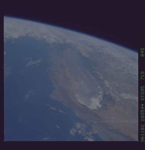
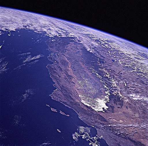
No GeoTIFF is available for this photo.Image Caption: Panoramic view of the Great Valley from the cloud covered San Joaquin
in the south to the Sacramento Valley in the north. The snow capped
Sierra Nevada Mountains line the eastern edge of the valley. Point
Conception is the prominent peninsula on the left side of the
image. The Channel Islands are separated from the mainland by the
Santa Barbara Channel. Further north along the coast are Monterey and
San Francisco Bays. Los Angeles is the gray area to the lower right.
