ISS060-E-44562
| NASA Photo ID | ISS060-E-44562 |
| Focal Length | 50mm |
| Date taken | 2019.08.25 |
| Time taken | 19:04:52 GMT |
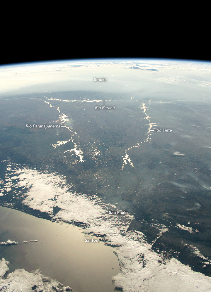


Photo center point: 22.5° S, 49.5° W
Photo center point by machine learning:
Country or Geographic Name: | BRAZIL |
Features: | RIO PARANA, RIO TIETE, RIO PARANAPANEMA, SUNGLINT, SAO PAULO, RESERVOIR |
| Features Found Using Machine Learning: | PAN- |
Cloud Cover Percentage: | 50 (26-50)% |
Sun Elevation Angle: | 20° |
Sun Azimuth: | 292° |
Camera: | Nikon D5 Electronic Still Camera |
Focal Length: | 50mm |
Camera Tilt: | High Oblique |
Format: | 5568E: 5568 x 3712 pixel CMOS sensor, 35.9 x 23.9 mm, total pixels: 21.33 million, Nikon FX format |
Film Exposure: | |
| Additional Information | |
| Width | Height | Annotated | Cropped | Purpose | Links |
|---|---|---|---|---|---|
| 720 pixels | 999 pixels | Yes | No | NASA's Earth Observatory web site | Download Image |
| 3712 pixels | 5568 pixels | No | No | Download Image | |
| 427 pixels | 640 pixels | No | No | Download Image |
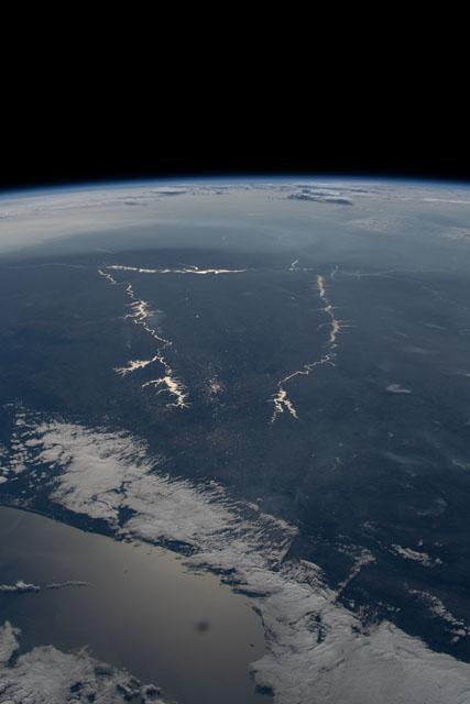
An astronaut aboard the International Space Station (ISS) focused a long camera lens on the Sun's reflection point while orbiting over southern coastal Brazil. That reflection (known as sunglint) highlights three major rivers: Rio Parana, Rio Tiete and Rio Paranapanema.
For scale, the Atlantic Ocean near the port city of Santos is about 600 kilometers (400 miles) from the Parana River. The sea surface also reflects sunlight, as does the smoke pall across the top of the image. The smoke came from fires that were burning further north in Brazil and Paraguay.
Such views looking toward the sunglint point show the water bodies in stark detail. But the contrast with dark land surfaces causes such a loss of detail that the entire metropolitan area of Sao Paulo, with its 30 million inhabitants, is mostly obscured.
The Rio Tiete flows right through the metro region from headwaters north of Sao Paulo. This river provides half of the region's urban water supply. All of these rivers are heavily controlled by strings of reservoirs that retain water flow for use by the major cities and to generate hydroelectric power. The reservoirs all appear as the brightest, widest points along the river courses.
