< STS043-151-43 >
| NASA Photo ID | STS043-151-43 |
| Focal Length | 90mm |
| Date taken | 1991.08.08 |
| Time taken | 14:42:38 GMT |
Resolutions offered for this image:
640 x 480 pixels
640 x 480 pixels
Cloud masks available for this image:
Spacecraft nadir point: 26.1° N, 97.6° W
Photo center point: 26.0° N, 98.0° W
Photo center point by machine learning:
Photo center point: 26.0° N, 98.0° W
Photo center point by machine learning:
Nadir to Photo Center: West
Spacecraft Altitude: 176 nautical miles (326km)Body: Earth
Country or Geographic Name: | USA-TEXAS |
Features: | FALCON RES., BROWNSVILLE |
| Features Found Using Machine Learning: | |
Cloud Cover Percentage: | 20 (11-25)% |
Sun Elevation Angle: | 35° |
Sun Azimuth: | 87° |
Camera: | Linhof |
Focal Length: | 90mm |
Camera Tilt: | 8 degrees |
Format: | QX868: Kodak, natural color positive, Ektachrome QX868(5017 emulsion), ASA 64, thin base |
Film Exposure: | Normal |
| Additional Information | |
| Width | Height | Annotated | Cropped | Purpose | Links |
|---|---|---|---|---|---|
| 640 pixels | 480 pixels | No | No | ISD 1 | Download Image |
Download Packaged File
Download a Google Earth KML for this Image
View photo footprint information
No GeoTIFF is available for this photo.Image Caption: STS043-151-43 - Rio Grande Delta, Texas and Mexico
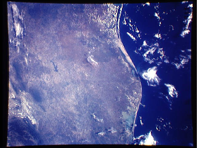
The Rio Grande extends across the center of this photograph from Falcon Reservoir to its bulging delta, joining the Gulf of Mexico. Sediment brought down by the river is spread northward and southward by alongshore currents to form the barrier chain of Padre Island and its protected Laguna Madre. Speckled agricultural land use patterns in the river valley contrast with rangeland northward from the white cloud, and with closed-canopy forest on hills in Mexico. This photograph was taken with a Linhof camera, 90 mm lens, on 8 August 1991, 14:43 GMT.
The Rio Grande River extends across the center of this photo from Falcon Reservoir, Brownsville (26.0N, 98.0W) to its bulging delta, joining the Gulf of Mexico. Sediment brought down by the river flows both north and south by the alongshore currents to form the barrier chain of Padre Island and its protected Laguna Madre. Agricultural land use patterns in the river valley contrast with the rangeland to the north and forests in Mexico to the south.
The Rio Grande extends across the center of this photograph from Falcon Reservoir to its bulging delta, joining the Gulf of Mexico. Sediment brought down by the river is spread northward and southward by alongshore currents to form the barrier chain of Padre Island and its protected Laguna Madre. Speckled agricultural land use patterns in the river valley contrast with rangeland northward from the white cloud, and with closed-canopy forest on hills in Mexico. This photograph was taken with a Linhof camera, 90 mm lens, on 8 August 1991, 14:43 GMT.
The Rio Grande River extends across the center of this photo from Falcon Reservoir, Brownsville (26.0N, 98.0W) to its bulging delta, joining the Gulf of Mexico. Sediment brought down by the river flows both north and south by the alongshore currents to form the barrier chain of Padre Island and its protected Laguna Madre. Agricultural land use patterns in the river valley contrast with the rangeland to the north and forests in Mexico to the south.

