< NM23-757-43 >
| NASA Photo ID | NM23-757-43 |
| Focal Length | 100mm |
| Date taken | 1997.05.01 |
| Time taken | 09:44:22 GMT |
Resolutions offered for this image:
4072 x 4096 pixels 636 x 640 pixels 5700 x 6000 pixels 500 x 526 pixels
4072 x 4096 pixels 636 x 640 pixels 5700 x 6000 pixels 500 x 526 pixels


Cloud masks available for this image:
Spacecraft nadir point: 44.3° N, 5.4° E
Photo center point: 42.0° N, 0.0° E
Photo center point by machine learning:
Photo center point: 42.0° N, 0.0° E
Photo center point by machine learning:
Nadir to Photo Center: West
Spacecraft Altitude: 208 nautical miles (385km)
Country or Geographic Name: | SPAIN |
Features: | PYRENEES MOUNTAINS |
| Features Found Using Machine Learning: | |
Cloud Cover Percentage: | 0 (no clouds present) |
Sun Elevation Angle: | 53° |
Sun Azimuth: | 132° |
Camera: | Hasselblad |
Focal Length: | 100mm |
Camera Tilt: | Low Oblique |
Format: | 5046: Kodak, natural color positive, Lumiere 100/5046, ASA 100, standard base |
Film Exposure: | Normal |
| Additional Information | |
| Width | Height | Annotated | Cropped | Purpose | Links |
|---|---|---|---|---|---|
| 4072 pixels | 4096 pixels | No | No | Earth From Space collection | Download Image |
| 636 pixels | 640 pixels | No | No | Earth From Space collection | Download Image |
| 5700 pixels | 6000 pixels | No | No | Download Image | |
| 500 pixels | 526 pixels | No | No | Download Image |
Download Packaged File
Download a Google Earth KML for this Image
View photo footprint information
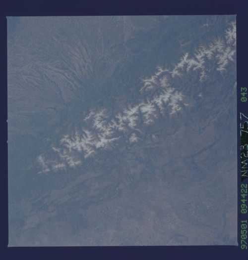
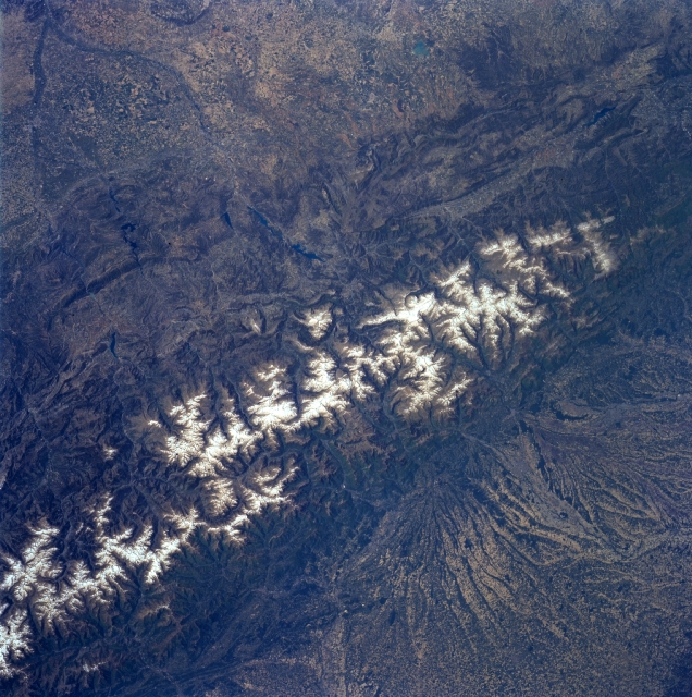
No GeoTIFF is available for this photo.Image Caption: NM23-757-043 Pyrenees Mountains, France and Spain Winter/Spring 1997
The east to west trending snow capped Pyrenees Mountains form a natural border between France (north-bottom) and Spain (south-top). The landscape of the landforms on either side of the mountains is dramatically different. Large, alluvial fans can be seen radiating northward providing rich soils for a thriving agricultural economy on the French side of the mountains. While south of the mountains in Spain, the landscape is more rugged with numerous escarpments and steep cliffs that parallel the main axis of the Pyrenees. Within the higher elevations of the Pyrenees, numerous, deep glacially formed U-shaped valleys are arrayed in no set pattern. The picturesque but rugged terrain of the Pyrenees Mountains offer a natural environment for a variety of tourist attractions that includes hiking trails, sightseeing venues, health spas, winter and summer sports, as well as fine cuisine. The Principality of Andorra, a small mountainous country with only 187 square miles (486 square km) of territory and an estimated population of 63000 permanent residents, can be located towards the lower left corner of the image.
The east to west trending snow capped Pyrenees Mountains form a natural border between France (north-bottom) and Spain (south-top). The landscape of the landforms on either side of the mountains is dramatically different. Large, alluvial fans can be seen radiating northward providing rich soils for a thriving agricultural economy on the French side of the mountains. While south of the mountains in Spain, the landscape is more rugged with numerous escarpments and steep cliffs that parallel the main axis of the Pyrenees. Within the higher elevations of the Pyrenees, numerous, deep glacially formed U-shaped valleys are arrayed in no set pattern. The picturesque but rugged terrain of the Pyrenees Mountains offer a natural environment for a variety of tourist attractions that includes hiking trails, sightseeing venues, health spas, winter and summer sports, as well as fine cuisine. The Principality of Andorra, a small mountainous country with only 187 square miles (486 square km) of territory and an estimated population of 63000 permanent residents, can be located towards the lower left corner of the image.
