ISS029-E-41836
| NASA Photo ID | ISS029-E-41836 |
| Focal Length | 1200mm |
| Date taken | 2011.10.04 |
| Time taken | 16:31:36 GMT |
Resolutions offered for this image:
1000 x 642 pixels 540 x 347 pixels 720 x 480 pixels 4256 x 2832 pixels 640 x 426 pixels
1000 x 642 pixels 540 x 347 pixels 720 x 480 pixels 4256 x 2832 pixels 640 x 426 pixels

Spacecraft nadir point: 49.2° S, 45.6° W
Photo center point: 63.3° S, 61.1° W
Photo center point by machine learning:
Photo center point: 63.3° S, 61.1° W
Photo center point by machine learning:
Nadir to Photo Center: Southwest
Spacecraft Altitude: 206 nautical miles (382km)
Country or Geographic Name: | ANTARCTICA |
Features: | DECEPTION ISLAND, HOSEASON ISLAND, BRABANT ISLAND, ANTARCTIC PENINSULA |
| Features Found Using Machine Learning: | |
Cloud Cover Percentage: | 10 (1-10)% |
Sun Elevation Angle: | 41° |
Sun Azimuth: | 326° |
Camera: | Nikon D3 Electronic Still Camera |
Focal Length: | 1200mm |
Camera Tilt: | High Oblique |
Format: | 4256E: 4256 x 2832 pixel CMOS sensor, 36.0mm x 23.9mm, total pixels: 12.87 million, Nikon FX format |
Film Exposure: | |
| Additional Information | |
| Width | Height | Annotated | Cropped | Purpose | Links |
|---|---|---|---|---|---|
| 1000 pixels | 642 pixels | No | Yes | Earth From Space collection | Download Image |
| 540 pixels | 347 pixels | Yes | Yes | Earth From Space collection | Download Image |
| 720 pixels | 480 pixels | Yes | Yes | NASA's Earth Observatory web site | Download Image |
| 4256 pixels | 2832 pixels | No | No | Download Image | |
| 640 pixels | 426 pixels | No | No | Download Image |
Download Packaged File
Download a Google Earth KML for this Image
View photo footprint information
Download a GeoTIFF for this photo
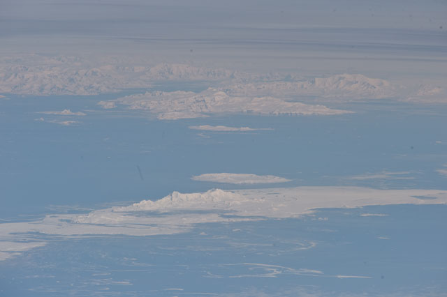
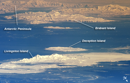
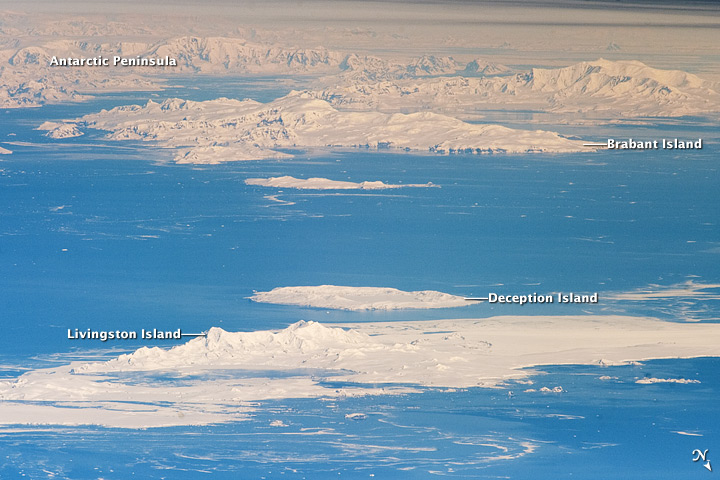
Image Caption: International Space Station View of South Shetland Islands and Antarctic Peninsula
Note: This caption refers to the image versions labeled "NASA's Earth Observatory web site".
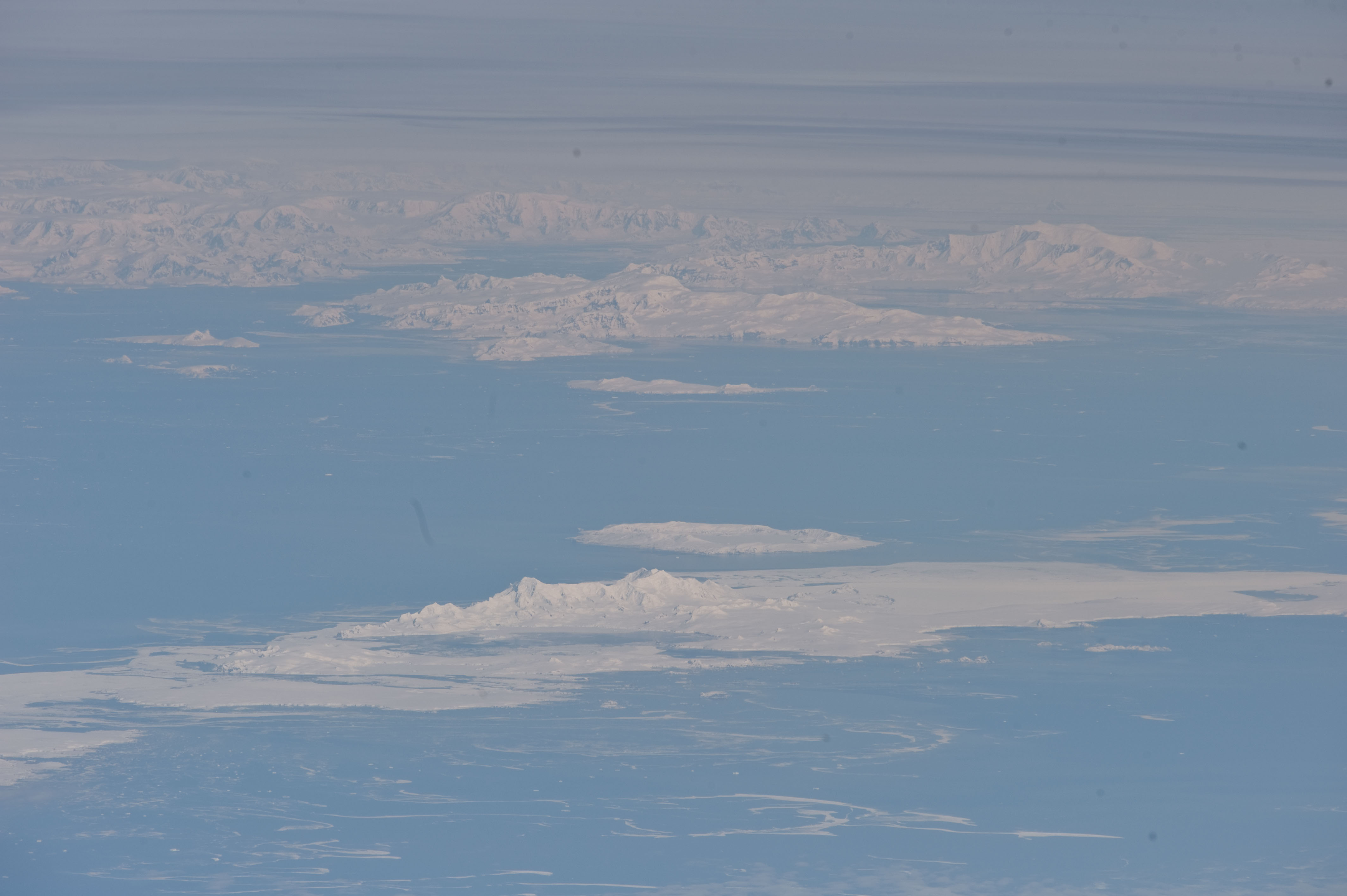
The inclined equatorial orbit of the International Space Station (ISS) limits nadir Earth views--looking "straight down" at the surface from the spacecraft--to latitudes between approximately 52 North and 52 South. When viewing conditions are ideal, the crew can obtain detailed oblique imagery--looking outwards at an angle from the ISS--of regions at higher latitudes such as Greenland or, in this image, Antarctica. While the bulk of the continent of Antarctica is currently situated over the South Pole, the narrow Antarctic Peninsula extends like a finger towards the southern tip of South America. The northernmost part of the Peninsula is known as Graham Land, a small portion of which (located at approximately 64 South latitude) can be seen at image top left in this astronaut photograph.
Two of the South Shetland Islands that lay off the coast of Graham Land to the north-northwest, Livingston Island and Deception Island, are visible in the image. While both islands have a volcanic origin, active volcanism at Deception Island has been recorded since 1800; the last verified eruptive activity occurred in 1970. Closer to the coastline of Graham Land, Brabant Island (not considered to be part of the South Shetlands) also includes numerous outcrops of volcanic rock attesting to the complex tectonic history of the region.
The ISS was located over the South Atlantic Ocean, approximately 1800 kilometers to the northeast in terms of its ground track, when this image was taken. This long viewing distance, combined with the highly oblique viewing angle, accentuates shadowing of the ground surface and provides a sense of the topography similar to the view one gets from an airplane. It also causes foreshortening of features visible in the image, making them appear closer to each other than they actually are - for example, the actual distance between Livingston and Deception Islands is approximately 20 kilometers.
Note: This caption refers to the image versions labeled "NASA's Earth Observatory web site".
The inclined equatorial orbit of the International Space Station (ISS) limits nadir Earth views--looking "straight down" at the surface from the spacecraft--to latitudes between approximately 52 North and 52 South. When viewing conditions are ideal, the crew can obtain detailed oblique imagery--looking outwards at an angle from the ISS--of regions at higher latitudes such as Greenland or, in this image, Antarctica. While the bulk of the continent of Antarctica is currently situated over the South Pole, the narrow Antarctic Peninsula extends like a finger towards the southern tip of South America. The northernmost part of the Peninsula is known as Graham Land, a small portion of which (located at approximately 64 South latitude) can be seen at image top left in this astronaut photograph.
Two of the South Shetland Islands that lay off the coast of Graham Land to the north-northwest, Livingston Island and Deception Island, are visible in the image. While both islands have a volcanic origin, active volcanism at Deception Island has been recorded since 1800; the last verified eruptive activity occurred in 1970. Closer to the coastline of Graham Land, Brabant Island (not considered to be part of the South Shetlands) also includes numerous outcrops of volcanic rock attesting to the complex tectonic history of the region.
The ISS was located over the South Atlantic Ocean, approximately 1800 kilometers to the northeast in terms of its ground track, when this image was taken. This long viewing distance, combined with the highly oblique viewing angle, accentuates shadowing of the ground surface and provides a sense of the topography similar to the view one gets from an airplane. It also causes foreshortening of features visible in the image, making them appear closer to each other than they actually are - for example, the actual distance between Livingston and Deception Islands is approximately 20 kilometers.
