< ISS034-E-39331 >
| NASA Photo ID | ISS034-E-39331 |
| Focal Length | 180mm |
| Date taken | 2013.02.02 |
| Time taken | 23:39:57 GMT |

Cloud masks available for this image:
Spacecraft nadir point: 50.3° N, 1.8° W
Photo center point:
Photo center point by machine learning:
Photo center point:
Photo center point by machine learning:
Nadir to Photo Center:
Spacecraft Altitude: 222 nautical miles (411km)
Country or Geographic Name: | |
Features: | |
| Features Found Using Machine Learning: | |
Cloud Cover Percentage: | |
Sun Elevation Angle: | -55° |
Sun Azimuth: | 343° |
Camera: | NIKON D3S S/N: 2053892 |
Focal Length: | 180mm |
Camera Tilt: | |
Format: | |
Film Exposure: | |
| Additional Information | |
| Width | Height | Annotated | Cropped | Purpose | Links |
|---|---|---|---|---|---|
| 4256 pixels | 2832 pixels | No | No | Download Image | |
| 640 pixels | 426 pixels | No | No | Download Image |
Download Packaged File
Download a Google Earth KML for this Image
View photo footprint information
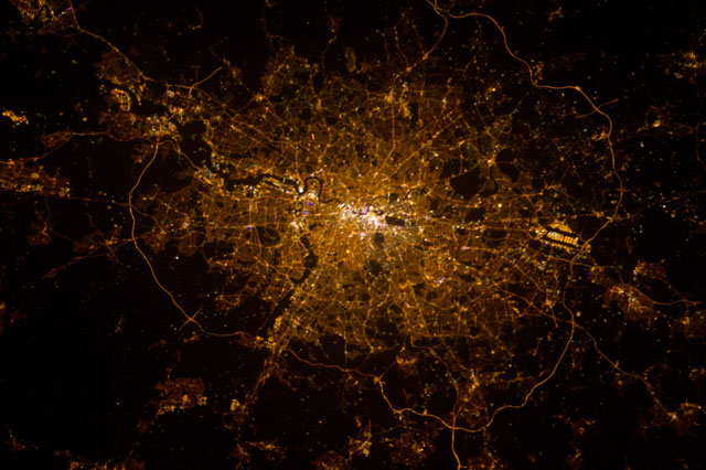
No GeoTIFF is available for this photo.Image Caption: This nocturnal photo of London, England was down-linked by the Expedition 34 crew from the International Space Station, flying approximately 240 miles above Earth, on February 2, 2013. Flight Engineer Chris Hadfield, astronaut with the Canadian Space Agency added this footnote to his down-link: "London, on the Thames, from the city to the encircling motorway. Heathrow very visible on the left." North is at the bottom making west on the right. Heathrow is west of London. In this image it's the bright feature with dark parallel lines near the outer looping road.
