< STS030-152-39 >
| NASA Photo ID | STS030-152-39 |
| Focal Length | 90mm |
| Date taken | 1989.05.06 |
| Time taken | 17:57:47 GMT |
Resolutions offered for this image:
640 x 480 pixels
640 x 480 pixels
Cloud masks available for this image:
Spacecraft nadir point: 10.8° N, 7.8° W
Photo center point:
Photo center point by machine learning:
Photo center point:
Photo center point by machine learning:
Nadir to Photo Center:
Spacecraft Altitude: 163 nautical miles (302km)
Country or Geographic Name: | AFRICA |
Features: | CLOUDS |
| Features Found Using Machine Learning: | |
Cloud Cover Percentage: | 100 (76-100)% |
Sun Elevation Angle: | 10° |
Sun Azimuth: | 285° |
Camera: | Linhof |
Focal Length: | 90mm |
Camera Tilt: | High Oblique |
Format: | 5017: Kodak, natural color positive, Ektachrome, X Professional, ASA 64, standard base |
Film Exposure: | Normal |
| Additional Information | |
| Width | Height | Annotated | Cropped | Purpose | Links |
|---|---|---|---|---|---|
| 640 pixels | 480 pixels | No | No | ISD 1 | Download Image |
Download Packaged File
Download a Google Earth KML for this Image
View photo footprint information
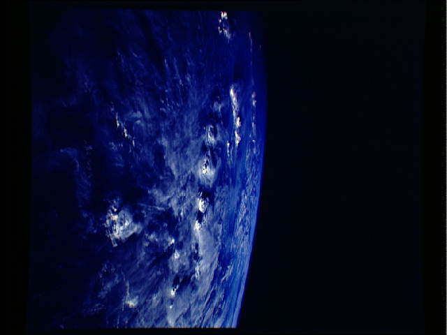
No GeoTIFF is available for this photo.Image Caption: The overshooting tops of a series of strong thunderstorms are seen in this late afternoon scene over the African Ivory Coast, exact location unknown. The low sun angle of the setting sun casts long shadows, accentuating the shapes and heights of the clouds. This seasonal thunderstorm is an African Intertropical Front located along the land/sea breeze interface over the West African coastline and is a normal occurance for this time of year.
