< AS10-27-3873 >
| NASA Photo ID | AS10-27-3873 |
| Focal Length | mm |
| Date taken | |
| Time taken | GMT |

Cloud masks available for this image:
Spacecraft nadir point:
Photo center point:
Photo center point by machine learning:
Photo center point:
Photo center point by machine learning:
Nadir to Photo Center:
Spacecraft Altitude: nautical miles (0km)
Country or Geographic Name: | |
Features: | |
| Features Found Using Machine Learning: | |
Cloud Cover Percentage: | |
Sun Elevation Angle: | ° |
Sun Azimuth: | ° |
Camera: | |
Focal Length: | mm |
Camera Tilt: | |
Format: | |
Film Exposure: | |
| Additional Information | |
| Width | Height | Annotated | Cropped | Purpose | Links |
|---|---|---|---|---|---|
| 4400 pixels | 4600 pixels | No | No | Download Image | |
| 492 pixels | 515 pixels | No | No | Download Image |
Download Packaged File
Download a Google Earth KML for this Image
View photo footprint information
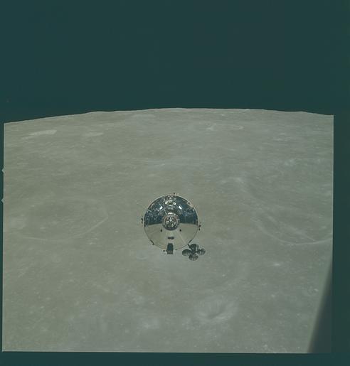
No GeoTIFF is available for this photo.Image Caption: The Apollo 10 Command and Service Modules (CSM) are photographed from the Lunar Module (LM) after CSM/LM separation in lunar orbit. The CSM was about 175 statute miles east of Smyth's Sea and was above the rough terrain which is typical of the lunar farside. The eastward oblique view of the lunar surface is centered near 105 degrees east longitude and 1 degree north latitude. The horizon is approximately 600 kilometers (374 statute miles) away. Numerous bright craters and the absence of shadows show that the sun was almost directly overhead when this photograph was taken.
