< STS095-713-38 >
| NASA Photo ID | STS095-713-38 |
| Focal Length | 40mm |
| Date taken | 1998.11.06 |
| Time taken | 10:45:57 GMT |

Cloud masks available for this image:
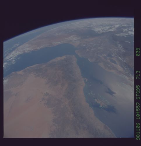
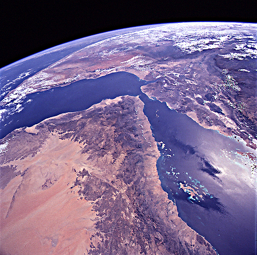
Spacecraft nadir point: 18.8° N, 42.7° E
Photo center point: 15.0° N, 44.0° E
Photo center point by machine learning:
Photo center point: 15.0° N, 44.0° E
Photo center point by machine learning:
Nadir to Photo Center: South
Spacecraft Altitude: 294 nautical miles (544km)
Country or Geographic Name: | YEMEN |
Features: | PAN-HIJAZ MASSIF, RED SEA |
| Features Found Using Machine Learning: | |
Cloud Cover Percentage: | 15 (11-25)% |
Sun Elevation Angle: | 46° |
Sun Azimuth: | 221° |
Camera: | Hasselblad |
Focal Length: | 40mm |
Camera Tilt: | High Oblique |
Format: | 5069: Kodak Elite 100S, E6 Reversal, Replaces Lumiere, Warmer in tone vs. Lumiere |
Film Exposure: | Out of Focus |
| Additional Information | |
| Width | Height | Annotated | Cropped | Purpose | Links |
|---|---|---|---|---|---|
| 5700 pixels | 5900 pixels | No | No | Download Image Download Color Calibration Image for this Image |
|
| 483 pixels | 500 pixels | No | No | Download Image Download Color Calibration Image for this Image |
|
| 517 pixels | 513 pixels | Earth From Space phase 2 | Download Image |
Download Packaged File
Download a Google Earth KML for this Image
View photo footprint information
No GeoTIFF is available for this photo.Image Caption: Red Sea/Gulf of Aden/Ethiopia. This southwestward view is an
outstanding illustration of the rift triple junction of East
Africa. As the Earth’s crust is stretched over a mangle hotspot,
three rifts are developing at 120deg angles to each other: the Red Sea,
the Gulf of Aden and the Ethiopian rift.
outstanding illustration of the rift triple junction of East
Africa. As the Earth’s crust is stretched over a mangle hotspot,
three rifts are developing at 120deg angles to each other: the Red Sea,
the Gulf of Aden and the Ethiopian rift.
