< ISS036-E-37747 >

| NASA Photo ID | ISS036-E-37747 |
| Focal Length | 180mm |
| Date taken | 2013.08.28 |
| Time taken | 16:48:33 GMT |
Spacecraft nadir point: 28.4° N, 95.0° W
Photo center point:
Photo center point by machine learning: 29.34° N, 94.80° W
Photo center point:
Photo center point by machine learning: 29.34° N, 94.80° W
Nadir to Photo Center:
Spacecraft Altitude: 221 nautical miles (409km)

Country or Geographic Name: | |
Features: | |
| Features Found Using Machine Learning: | |
Cloud Cover Percentage: | 1 (1-10)% |
Sun Elevation Angle: | 61° |
Sun Azimuth: | 126° |
Camera: | NIKON D3S S/N: 2053892 |
Focal Length: | 180mm |
Camera Tilt: | |
Format: | |
Film Exposure: | |
| Additional Information | |
| Width | Height | Annotated | Cropped | Purpose | Links |
|---|---|---|---|---|---|
| 2832 pixels | 4256 pixels | No | No | Download Image | |
| 426 pixels | 640 pixels | No | No | Download Image |
Download Packaged File
Download a Google Earth KML for this Image
View photo footprint information
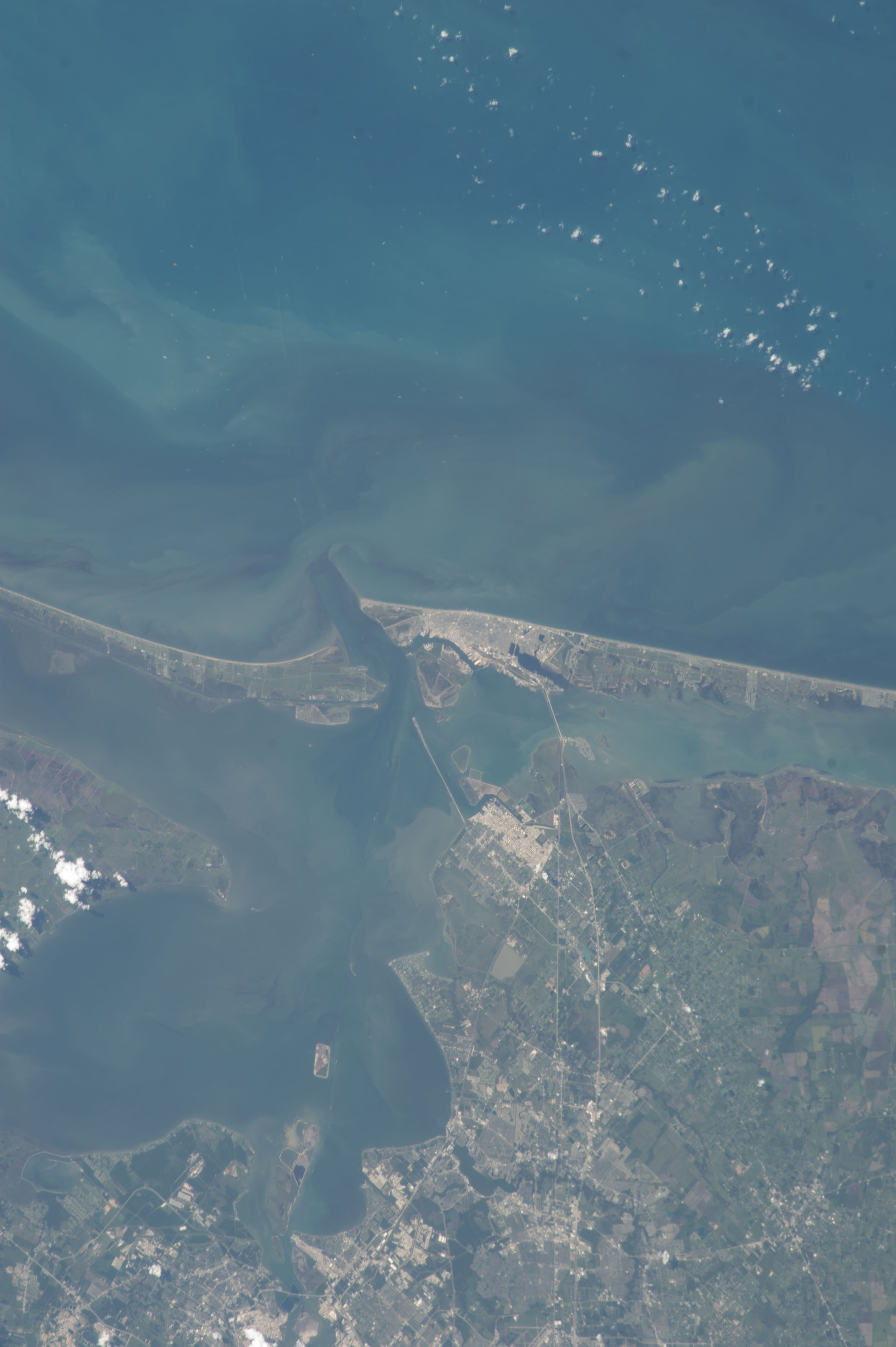
No GeoTIFF is available for this photo.Image Caption: ISS036-E-037747 (28 Aug. 2013) --- One of the
Expedition 36 crew members aboard the International Space Station on Aug. 28 photographed this vertical image that shows much of Galveston County and a small portion of southeast Harris County, Texas. Gulf of Mexico waters take up the top half of the picture. Galveston Island runs from just left of center through center right of the image, and the Bolivar Peninsula, highly impacted by Hurricane Ike five years ago, is the land mass at left center. Galveston Bay takes up much of the lower left quadrant of the pictured area. The NASA Johnson Space Center, the normal work place for NASA astronauts Chris Cassidy and Karen Nyberg, currently onboard the orbital complex, is in the bottom portion of the frame.
Expedition 36 crew members aboard the International Space Station on Aug. 28 photographed this vertical image that shows much of Galveston County and a small portion of southeast Harris County, Texas. Gulf of Mexico waters take up the top half of the picture. Galveston Island runs from just left of center through center right of the image, and the Bolivar Peninsula, highly impacted by Hurricane Ike five years ago, is the land mass at left center. Galveston Bay takes up much of the lower left quadrant of the pictured area. The NASA Johnson Space Center, the normal work place for NASA astronauts Chris Cassidy and Karen Nyberg, currently onboard the orbital complex, is in the bottom portion of the frame.
