< STS079-785-37 >

| NASA Photo ID | STS079-785-37 |
| Focal Length | 100mm |
| Date taken | 1996.09.25 |
| Time taken | 03:52:10 GMT |

Cloud masks available for this image:
Spacecraft nadir point: 28.3° N, 72.9° E
Photo center point: 33.0° N, 76.0° E
Photo center point by machine learning:
Photo center point: 33.0° N, 76.0° E
Photo center point by machine learning:
Nadir to Photo Center: Northeast
Spacecraft Altitude: 201 nautical miles (372km)
Country or Geographic Name: | INDIA |
Features: | PAN-HIMALAYAS, V. KASHMIR |
| Features Found Using Machine Learning: | |
Cloud Cover Percentage: | 10 (1-10)% |
Sun Elevation Angle: | 36° |
Sun Azimuth: | 115° |
Camera: | Hasselblad |
Focal Length: | 100mm |
Camera Tilt: | High Oblique |
Format: | 5046: Kodak, natural color positive, Lumiere 100/5046, ASA 100, standard base |
Film Exposure: | Normal |
| Additional Information | |
| Width | Height | Annotated | Cropped | Purpose | Links |
|---|---|---|---|---|---|
| 5700 pixels | 5900 pixels | No | No | Download Image Download Color Calibration Image for this Image |
|
| 483 pixels | 500 pixels | No | No | Download Image Download Color Calibration Image for this Image |
|
| 610 pixels | 623 pixels | No | No | Download Image |
Download Packaged File
Download a Google Earth KML for this Image
View photo footprint information
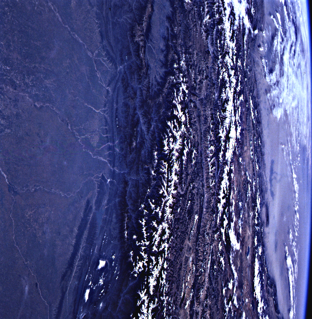
No GeoTIFF is available for this photo.Image Caption: These photographs of the southern front
of the Himalayan ranges provide a needed perspective on stream
adjustments along the mountain front in response to rapid uplift. At
the boundary where the Indian and Eurasian tectonic plates are
colliding, the Himalaya are rising -- and being denuded -- at an
estimated rate of 1 cm/year.
The five photographs above will be illustrations in a global tectonics
tutorial on Tectonic Plate Boundaries Observable from Space now in
preparation for use on the Space Station.
