< STS068-249-36 >
| NASA Photo ID | STS068-249-36 |
| Focal Length | 100mm |
| Date taken | 1994.10.09 |
| Time taken | 17:34:40 GMT |
Resolutions offered for this image:
3808 x 3872 pixels 629 x 639 pixels 5700 x 5900 pixels 500 x 518 pixels 640 x 480 pixels
3808 x 3872 pixels 629 x 639 pixels 5700 x 5900 pixels 500 x 518 pixels 640 x 480 pixels


Cloud masks available for this image:
Spacecraft nadir point: 44.9° N, 108.3° W
Photo center point: 45.0° N, 109.0° W
Photo center point by machine learning:
Photo center point: 45.0° N, 109.0° W
Photo center point by machine learning:
Nadir to Photo Center: West
Spacecraft Altitude: 110 nautical miles (204km)
Camera: | Hasselblad |
Focal Length: | 100mm |
Camera Tilt: | 21 degrees |
Format: | 5046: Kodak, natural color positive, Lumiere 100/5046, ASA 100, standard base |
Film Exposure: | Normal |
| Additional Information | |
| Width | Height | Annotated | Cropped | Purpose | Links |
|---|---|---|---|---|---|
| 3808 pixels | 3872 pixels | No | No | Earth From Space collection | Download Image |
| 629 pixels | 639 pixels | No | No | Earth From Space collection | Download Image |
| 5700 pixels | 5900 pixels | No | No | Download Image Download Color Calibration Image for this Image |
|
| 500 pixels | 518 pixels | No | No | Download Image Download Color Calibration Image for this Image |
|
| 640 pixels | 480 pixels | No | No | Download Image |
Download Packaged File
Download a Google Earth KML for this Image
View photo footprint information
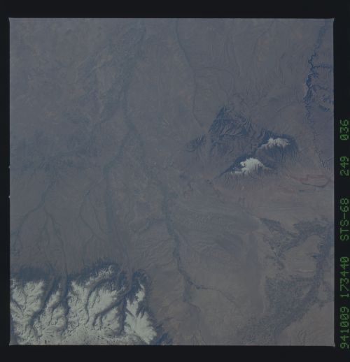
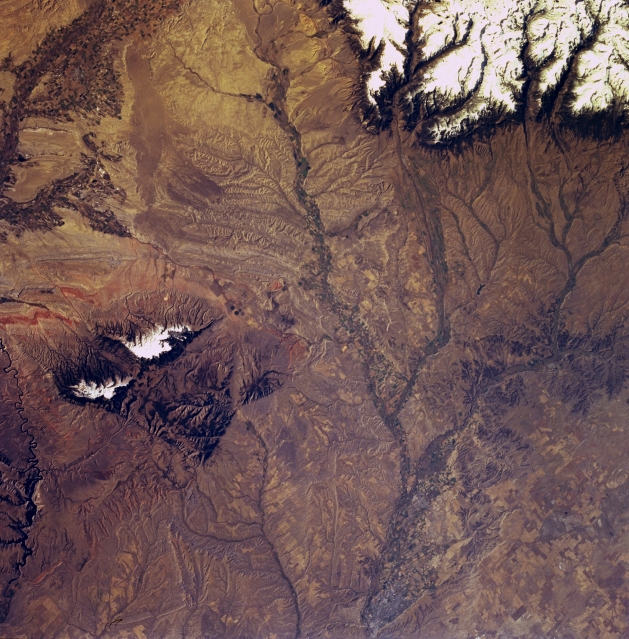
No GeoTIFF is available for this photo.Image Caption: STS068-249-036 Billings, Yellowstone River, and Pryor Mountains, Montana, U.S.A. October 1994
Billings, situated on the Yellowstone River in a valley surrounded by seven mountain ranges, is barely discernible in this south-southwest-looking, low-oblique photograph. The city is a trade and manufacturing center for the surrounding region and a shipping point for livestock, poultry, and wool. Oil refining, sugar refining, meat packing, and flour milling are the city's major industries. The eastern end of snow-covered Beartooth Plateau is visible in the top right of the photograph. Apparent along the bottom left is part of Yellowtail Dam on Bighorn Lake. West of the lake are the snowcapped peaks of the Pryor Mountains, the northern extension of the higher Bighorn Mountains (not discernible) further south in Wyoming. Irrigated fields in the Bighorn River Valley in Wyoming are visible.
Billings, situated on the Yellowstone River in a valley surrounded by seven mountain ranges, is barely discernible in this south-southwest-looking, low-oblique photograph. The city is a trade and manufacturing center for the surrounding region and a shipping point for livestock, poultry, and wool. Oil refining, sugar refining, meat packing, and flour milling are the city's major industries. The eastern end of snow-covered Beartooth Plateau is visible in the top right of the photograph. Apparent along the bottom left is part of Yellowtail Dam on Bighorn Lake. West of the lake are the snowcapped peaks of the Pryor Mountains, the northern extension of the higher Bighorn Mountains (not discernible) further south in Wyoming. Irrigated fields in the Bighorn River Valley in Wyoming are visible.
