< AS09-22-3407 >
| NASA Photo ID | AS09-22-3407 |
| Focal Length | 80mm |
| Date taken | 1969.03.09 |
| Time taken | 14:54:00 GMT |

Cloud masks available for this image:
Spacecraft nadir point:
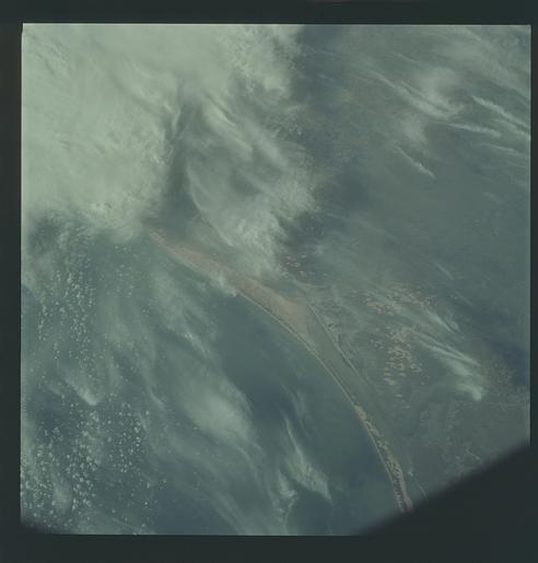
Photo center point: 26.8° N, 97.5° W
Photo center point by machine learning:
Photo center point: 26.8° N, 97.5° W
Photo center point by machine learning:
Nadir to Photo Center:
Spacecraft Altitude: 95 nautical miles (176km)
Country or Geographic Name: | USA-TEXAS |
Features: | PADRE ISLAND, BAFFIN BAY |
| Features Found Using Machine Learning: | |
Cloud Cover Percentage: | 35 (26-50)% |
Sun Elevation Angle: | 25° |
Sun Azimuth: | ° |
Camera: | Hasselblad |
Focal Length: | 80mm |
Camera Tilt: | Near Vertical |
Format: | SO368: Kodak Ektachrome MS, equivalent to 2448 Kodak Aerochrome, ASA64, thin base, fine grain |
Film Exposure: | Under Exposed |
| Additional Information | |
| Width | Height | Annotated | Cropped | Purpose | Links |
|---|---|---|---|---|---|
| 4400 pixels | 4600 pixels | No | No | Download Image | |
| 492 pixels | 515 pixels | No | No | Download Image |
Download Packaged File
Download a Google Earth KML for this Image
View photo footprint information
No GeoTIFF is available for this photo.Image Caption: GEOGRAPHY/CARTOGRAPHY: UNITED STATES, TEXAS, PADRE ISLAND, MADRE LAGOON, BAFFIN AND ALAZAN BAYS, TOWNS OF KINGSVILLE AND RIVIERA.
GEOLOGY/HYDROLOGY: COASTAL PLAINS LAGOONS AND SANDBARS ALONG SHORELINE.
AGRICULTURE: SMALL IRREGULAR SHAPED FIELD PATTERNS.
FORESTRY: DECIDUOUS SHRUBFORM WITH SOME EVERGREEN SHRUBFORM.
METEOROLOGY: ALTO-STRATUS, CIRRUS UNCINUS.
OCEANOGRAPHY:
GEOLOGY/HYDROLOGY: COASTAL PLAINS LAGOONS AND SANDBARS ALONG SHORELINE.
AGRICULTURE: SMALL IRREGULAR SHAPED FIELD PATTERNS.
FORESTRY: DECIDUOUS SHRUBFORM WITH SOME EVERGREEN SHRUBFORM.
METEOROLOGY: ALTO-STRATUS, CIRRUS UNCINUS.
OCEANOGRAPHY:
