< ISS036-E-32853 >
| NASA Photo ID | ISS036-E-32853 |
| Focal Length | 50mm |
| Date taken | 2013.08.18 |
| Time taken | 23:20:02 GMT |
Resolutions offered for this image:
1000 x 665 pixels 540 x 359 pixels 1440 x 960 pixels 720 x 480 pixels 4256 x 2832 pixels 640 x 426 pixels
1000 x 665 pixels 540 x 359 pixels 1440 x 960 pixels 720 x 480 pixels 4256 x 2832 pixels 640 x 426 pixels


Spacecraft nadir point: 43.8° N, 111.4° W
Photo center point: 44.5° N, 114.5° W
Photo center point by machine learning:
Photo center point: 44.5° N, 114.5° W
Photo center point by machine learning:
Nadir to Photo Center: West
Spacecraft Altitude: 221 nautical miles (409km)
Country or Geographic Name: | USA-IDAHO |
Features: | SALMON R. MTS., WILDFIRES AND SMOKE PLUMES |
| Features Found Using Machine Learning: | |
Cloud Cover Percentage: | 10 (1-10)% |
Sun Elevation Angle: | 32° |
Sun Azimuth: | 256° |
Camera: | Nikon D3 Electronic Still Camera |
Focal Length: | 50mm |
Camera Tilt: | 41 degrees |
Format: | 4256E: 4256 x 2832 pixel CMOS sensor, 36.0mm x 23.9mm, total pixels: 12.87 million, Nikon FX format |
Film Exposure: | |
| Additional Information | |
| Width | Height | Annotated | Cropped | Purpose | Links |
|---|---|---|---|---|---|
| 1000 pixels | 665 pixels | No | Yes | Earth From Space collection | Download Image |
| 540 pixels | 359 pixels | Yes | Yes | Earth From Space collection | Download Image |
| 1440 pixels | 960 pixels | No | No | NASA's Earth Observatory web site | Download Image |
| 720 pixels | 480 pixels | Yes | No | NASA's Earth Observatory web site | Download Image |
| 4256 pixels | 2832 pixels | No | No | Download Image | |
| 640 pixels | 426 pixels | No | No | Download Image |
Download Packaged File
Download a Google Earth KML for this Image
View photo footprint information
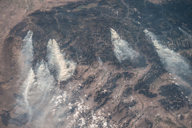
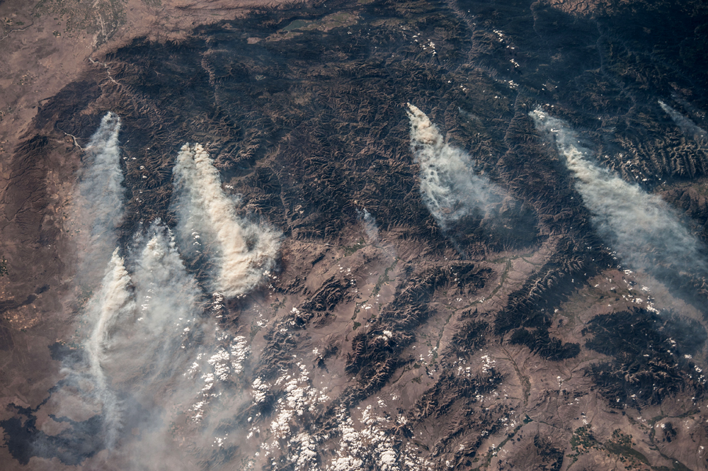
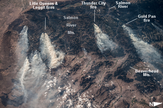
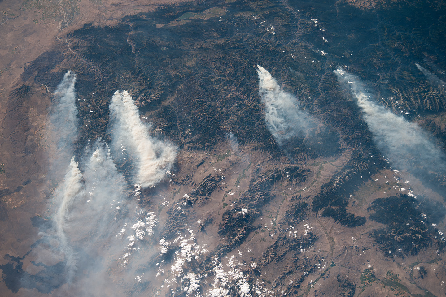
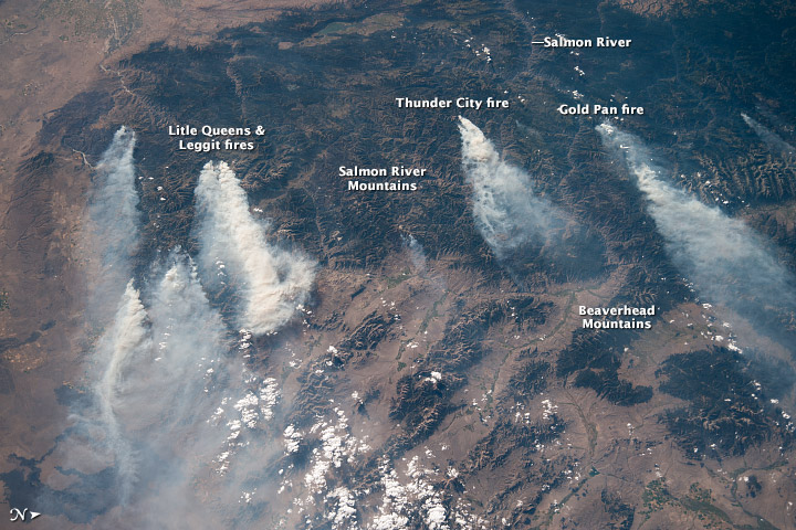
No GeoTIFF is available for this photo.Image Caption: Central Idaho Wildfires, August 2013
Note: This caption refers to the image versions labeled "NASA's Earth Observatory web site".
Taken with a short lens (50 mm), this west-looking image from the International Space Station covers much of forested central Idaho--the dark areas are all wooded mountains. The image highlights part of the largest single wilderness area in the contiguous United States (the Frank Church-River of No Return Wilderness). Within this mountainous region, several fires can be seen producing extensive smoke plumes. Some fires had been named by August 20, 2013, two days after the image was taken. The densest smoke on that day appears to be generated by a combination of the Little Queens and Leggit fires (image left, within the Salmon River Mountains).
The named fires were mostly set by lightning, and on August 20, 2013 totaled 53,000 acres of burned forest south of the Salmon River, and many more if the unnamed fires are included. The Gold Pan fire north of the Salmon River had burned 27,000 acres. For a sense of scale in this oblique view, the Gold Pan fire lies about 125 miles north of the Little Queens fire.
This image shows the common pattern of westerly winds transporting smoke in an easterly direction, as seen during the wildfire season of one year ago. Ten days before this image was taken, fires in central Idaho near Boise were aggravated by southerly winds.
Some of the fires began to burn in July but were quelled and remain under observation for new flareups. Smoke from fires in the south partly obscures the black lava flows of the Craters of the Moon National Monument (image lower left). The Beaverhead Mts. mark the eastern boundary of Idaho with Montana.
