< STS043-151-32 >
| NASA Photo ID | STS043-151-32 |
| Focal Length | 90mm |
| Date taken | 1991.08.08 |
| Time taken | 13:40:26 GMT |

Cloud masks available for this image:
Spacecraft nadir point: 20.1° S, 24.7° E
Photo center point: 19.0° S, 22.0° E
Photo center point by machine learning:
Photo center point: 19.0° S, 22.0° E
Photo center point by machine learning:
Nadir to Photo Center: West
Spacecraft Altitude: 165 nautical miles (306km)Body: Earth
Country or Geographic Name: | BOTSWANA |
Features: | PAN, OKAVANGO DELTA, SMOKE |
| Features Found Using Machine Learning: | |
Cloud Cover Percentage: | 0 (no clouds present) |
Sun Elevation Angle: | 30° |
Sun Azimuth: | 303° |
Camera: | Linhof |
Focal Length: | 90mm |
Camera Tilt: | High Oblique |
Format: | QX868: Kodak, natural color positive, Ektachrome QX868(5017 emulsion), ASA 64, thin base |
Film Exposure: | Normal |
| Additional Information | |
| Width | Height | Annotated | Cropped | Purpose | Links |
|---|---|---|---|---|---|
| 640 pixels | 480 pixels | No | No | ISD 1 | Download Image |
| 5216 pixels | 4096 pixels | No | No | Download Image | |
| 386 pixels | 453 pixels | Yes | No | Download Image |
Download Packaged File
Download a Google Earth KML for this Image
View photo footprint information
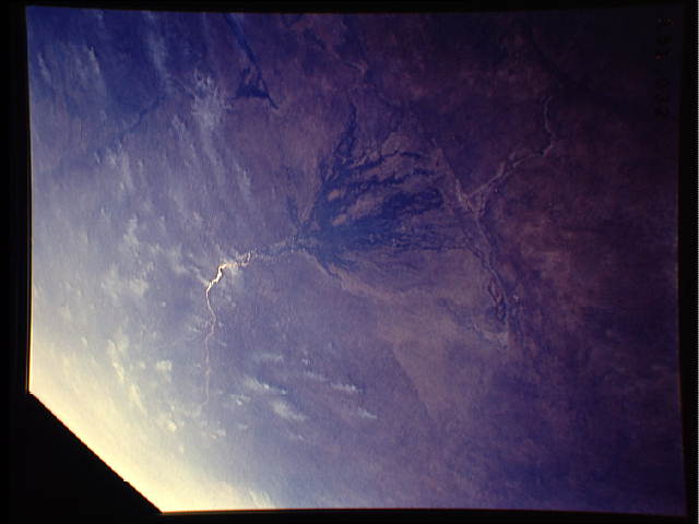
No GeoTIFF is available for this photo.Image Caption: Agricultural Fires across Africa north of the Okavango Swamp, Republic of Botswana. The Okavango River, seen in sunlight, flows into a structual antopographic trough to form an inland delta, the Okavango Swamp. Water is trapped in the meandering delta disturbutaries and is evaporated physically or transpired by vegetation, so that only during exreme floods does water flow out of the structual depression toward salt pans to the southeast. The crew of STS-43 captured seasonal burning of savannah vegetation to the north in Angola, and extremely hazy conditions perhaps caused by both smoke and dust, in central Africa. Linhof camera, 90 mm lens, 8 Aug 1991, 13:40 GMT.
In this panoramic view of the Okavango Swamp, Botswana, (19.0S, 22.0E), the Okavango River, seen in sunglint, flows into a topographic trough to form an inland delta. Water, trapped in the meandering delta distributaries is evaporated or transpired by vegetation. In Angola to the north, the many fires of the seasonal burning of savannah vegetation for land clearing, in preparation for agriculture, has filled the atmosphere with haze and smoke.
In this panoramic view of the Okavango Swamp, Botswana, (19.0S, 22.0E), the Okavango River, seen in sunglint, flows into a topographic trough to form an inland delta. Water, trapped in the meandering delta distributaries is evaporated or transpired by vegetation. In Angola to the north, the many fires of the seasonal burning of savannah vegetation for land clearing, in preparation for agriculture, has filled the atmosphere with haze and smoke.


