< STS033-75-31 >
| NASA Photo ID | STS033-75-31 |
| Focal Length | 250mm |
| Date taken | 1989.11.25 |
| Time taken | 02:37:08 GMT |
Resolutions offered for this image:
5700 x 5900 pixels 500 x 518 pixels 640 x 480 pixels 2628 x 2584 pixels
5700 x 5900 pixels 500 x 518 pixels 640 x 480 pixels 2628 x 2584 pixels


Cloud masks available for this image:
Spacecraft nadir point: 6.4° S, 129.5° E
Photo center point: 8.0° S, 130.0° E
Photo center point by machine learning:
Photo center point: 8.0° S, 130.0° E
Photo center point by machine learning:
Nadir to Photo Center: South
Spacecraft Altitude: 200 nautical miles (370km)Body: Earth
Country or Geographic Name: | INDONESIA |
Features: | PULAU BABAR, ISLAND WAKE |
| Features Found Using Machine Learning: | |
Cloud Cover Percentage: | 0 (no clouds present) |
Sun Elevation Angle: | 74° |
Sun Azimuth: | 153° |
Camera: | Hasselblad |
Focal Length: | 250mm |
Camera Tilt: | 27 degrees |
Format: | 5017: Kodak, natural color positive, Ektachrome, X Professional, ASA 64, standard base |
Film Exposure: | Normal |
| Additional Information | |
| Width | Height | Annotated | Cropped | Purpose | Links |
|---|---|---|---|---|---|
| 5700 pixels | 5900 pixels | No | No | Download Image | |
| 500 pixels | 518 pixels | No | No | Download Image | |
| 640 pixels | 480 pixels | No | No | Download Image | |
| 2628 pixels | 2584 pixels | Yes | ReefBase 1 | Download Image |
Download Packaged File
Download a Google Earth KML for this Image
View photo footprint information
No GeoTIFF is available for this photo.Image Caption:
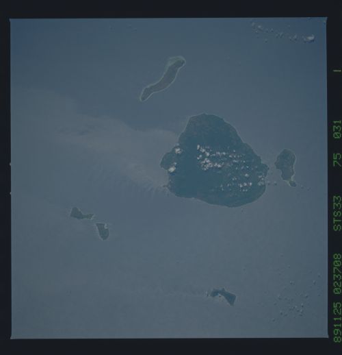
Babar Island, east of Timor between the Banda Sea and the Timor
Sea. The elongate small island is southeast of Babar. This pair
of photographs, taken 44 seconds apart (about 175 NM, 320 KM) il-
lustrates an effective use of sunglint. The island wake, which is
a difference in sea-surface roughness caused either by wind ac-
tion or current action or both, obviously has a different reflec-
tance when viewed from different directions. Internal waves that
border the island wake propagating from west to east are dif-
fracted by the island; much smaller wind waves extend east- west
at right angles to the swell. Turbulent "interference-like" wakes
are well-displayed downstream from Dai and Daweloor Islands,
northeast of Babar. S33-75-028, S33-75-031.
Babar Island, east of Timor between the Banda Sea and the Timor
Sea. The elongate small island is southeast of Babar. This pair
of photographs, taken 44 seconds apart (about 175 NM, 320 KM) il-
lustrates an effective use of sunglint. The island wake, which is
a difference in sea-surface roughness caused either by wind ac-
tion or current action or both, obviously has a different reflec-
tance when viewed from different directions. Internal waves that
border the island wake propagating from west to east are dif-
fracted by the island; much smaller wind waves extend east- west
at right angles to the swell. Turbulent "interference-like" wakes
are well-displayed downstream from Dai and Daweloor Islands,
northeast of Babar. S33-75-028, S33-75-031.

