< STS036-92-28 >

| NASA Photo ID | STS036-92-28 |
| Focal Length | 100mm |
| Date taken | 1990.03.03 |
| Time taken | 11:01:44 GMT |

Cloud masks available for this image:
Spacecraft nadir point: 17.6° S, 29.9° E
Photo center point: 17.5° S, 30.5° E
Photo center point by machine learning:
Photo center point: 17.5° S, 30.5° E
Photo center point by machine learning:
Nadir to Photo Center: East
Spacecraft Altitude: 131 nautical miles (243km)
Country or Geographic Name: | ZIMBABWE |
Features: | GR. DIKE, L. MCILWAINE, AGR. |
| Features Found Using Machine Learning: | |
Cloud Cover Percentage: | 5 (1-10)% |
Sun Elevation Angle: | 74° |
Sun Azimuth: | 310° |
Camera: | Hasselblad |
Focal Length: | 100mm |
Camera Tilt: | 16 degrees |
Format: | 2443: Kodak Aerochrome 2443, color IR, thin base, EA-5 process thru June 1999, E-6 process afterward |
Film Exposure: | Normal |
| Additional Information | |
| Width | Height | Annotated | Cropped | Purpose | Links |
|---|---|---|---|---|---|
| 5700 pixels | 5900 pixels | No | No | Download Image Download Color Calibration Image for this Image |
|
| 500 pixels | 518 pixels | No | No | Download Image Download Color Calibration Image for this Image |
|
| 640 pixels | 480 pixels | No | No | Download Image |
Download Packaged File
Download a Google Earth KML for this Image
View photo footprint information
No GeoTIFF is available for this photo.Image Caption:
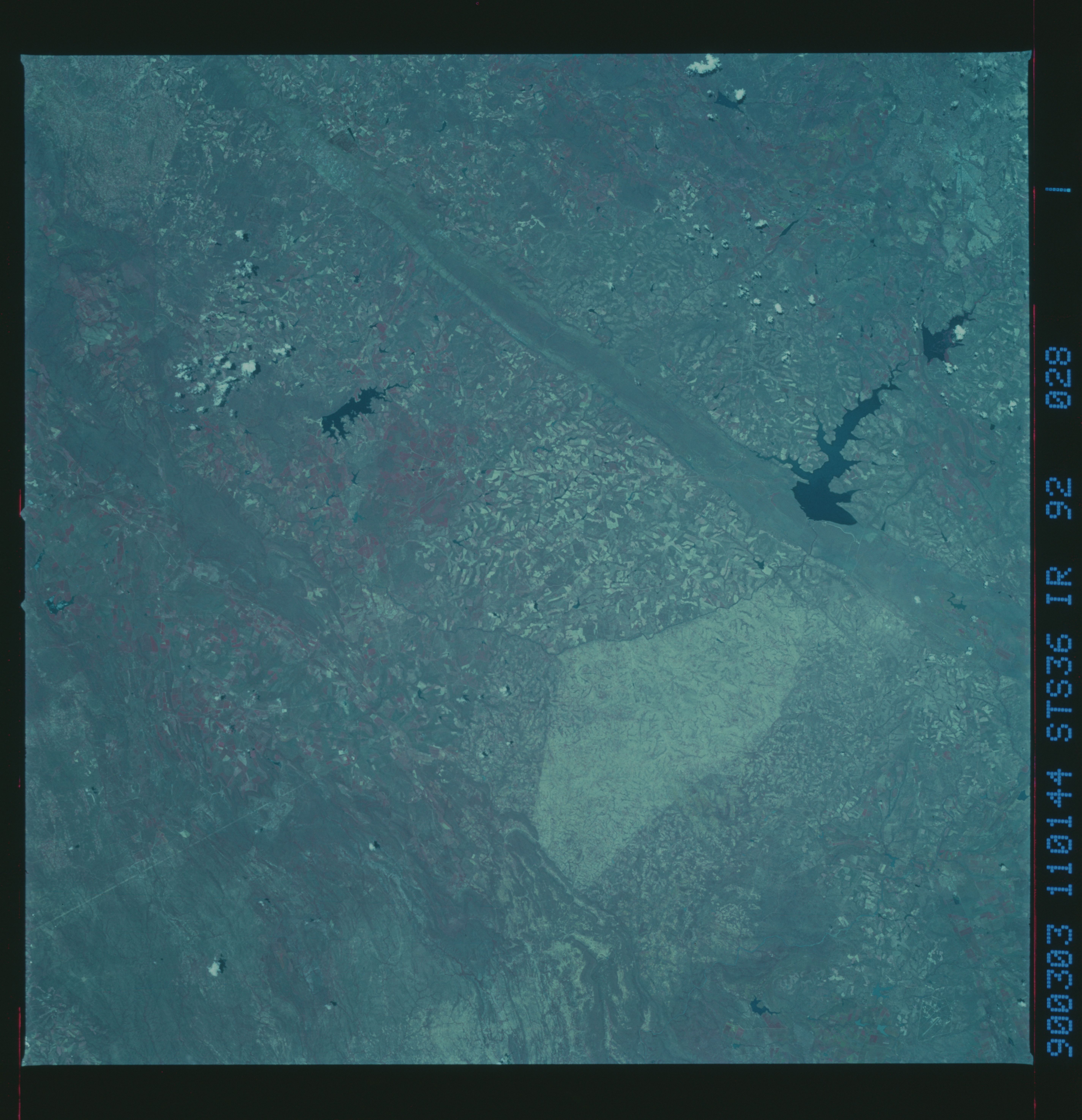
S36-92-028: Zimbabwe Farmland, CIR
Cutting through the old cratonic rocks in southern Africa is a
large sheet-like body known as the Great Dyke of Zimbabwe, an
easily recognizable dark linear feature which cuts north-south
across the Zimbabwe countryside for almost 500Jkm. The igneous
rocks which make up this intrusion contain economically important
reserves of several strategic minerals, including chromium and
the platinum group elements. The Great Dyke can be seen here
running from lower left to top center. Many details of the Great
Dyke are apparent in this slide. The linear symmetry on either
side of the Dyke indicates that it is folded slightly upward.
The oldest rocks are greenstone belts, appearing here as dark and
folded rocks in the lower right corner of the photo. These rocks
include very old ocean crust (greater than 2.5 billion years in
age) and are mined for iron ore and asbestos.
The light patch (upper center of slide) is an overgrazed Rtribal
trust land,S easily distinguished from the patterned land of com-
mercial farms.
The Hunyani River is conveniently dammed at the Great Dyke to
form Lake Belvedere. The capitol city Harare (formerly Salis-
bury) is just out of the field of view at the top of the slide.
