< STS079-783-26 >

| NASA Photo ID | STS079-783-26 |
| Focal Length | 250mm |
| Date taken | 1996.09.20 |
| Time taken | 14:47:38 GMT |
Resolutions offered for this image:
4061 x 4096 pixels 634 x 640 pixels 5700 x 5900 pixels 483 x 500 pixels 518 x 499 pixels 480 x 478 pixels
4061 x 4096 pixels 634 x 640 pixels 5700 x 5900 pixels 483 x 500 pixels 518 x 499 pixels 480 x 478 pixels

Cloud masks available for this image:
Spacecraft nadir point: 38.7° N, 77.5° W
Photo center point: 39.0° N, 76.5° W
Photo center point by machine learning:
Photo center point: 39.0° N, 76.5° W
Photo center point by machine learning:
Nadir to Photo Center: East
Spacecraft Altitude: 203 nautical miles (376km)
Country or Geographic Name: | USA-MARYLAND |
Features: | BALTIMORE, CHESAPEAKE B. |
| Features Found Using Machine Learning: | |
Cloud Cover Percentage: | 0 (no clouds present) |
Sun Elevation Angle: | 41° |
Sun Azimuth: | 132° |
Camera: | Hasselblad |
Focal Length: | 250mm |
Camera Tilt: | 17 degrees |
Format: | 5046: Kodak, natural color positive, Lumiere 100/5046, ASA 100, standard base |
Film Exposure: | Out of Focus |
| Additional Information | |
| Width | Height | Annotated | Cropped | Purpose | Links |
|---|---|---|---|---|---|
| 4061 pixels | 4096 pixels | No | No | Earth From Space collection | Download Image |
| 634 pixels | 640 pixels | No | No | Earth From Space collection | Download Image |
| 5700 pixels | 5900 pixels | No | No | Download Image Download Color Calibration Image for this Image |
|
| 483 pixels | 500 pixels | No | No | Download Image Download Color Calibration Image for this Image |
|
| 518 pixels | 499 pixels | No | No | Download Image | |
| 480 pixels | 478 pixels | Download Image |
Download Packaged File
Download a Google Earth KML for this Image
View photo footprint information
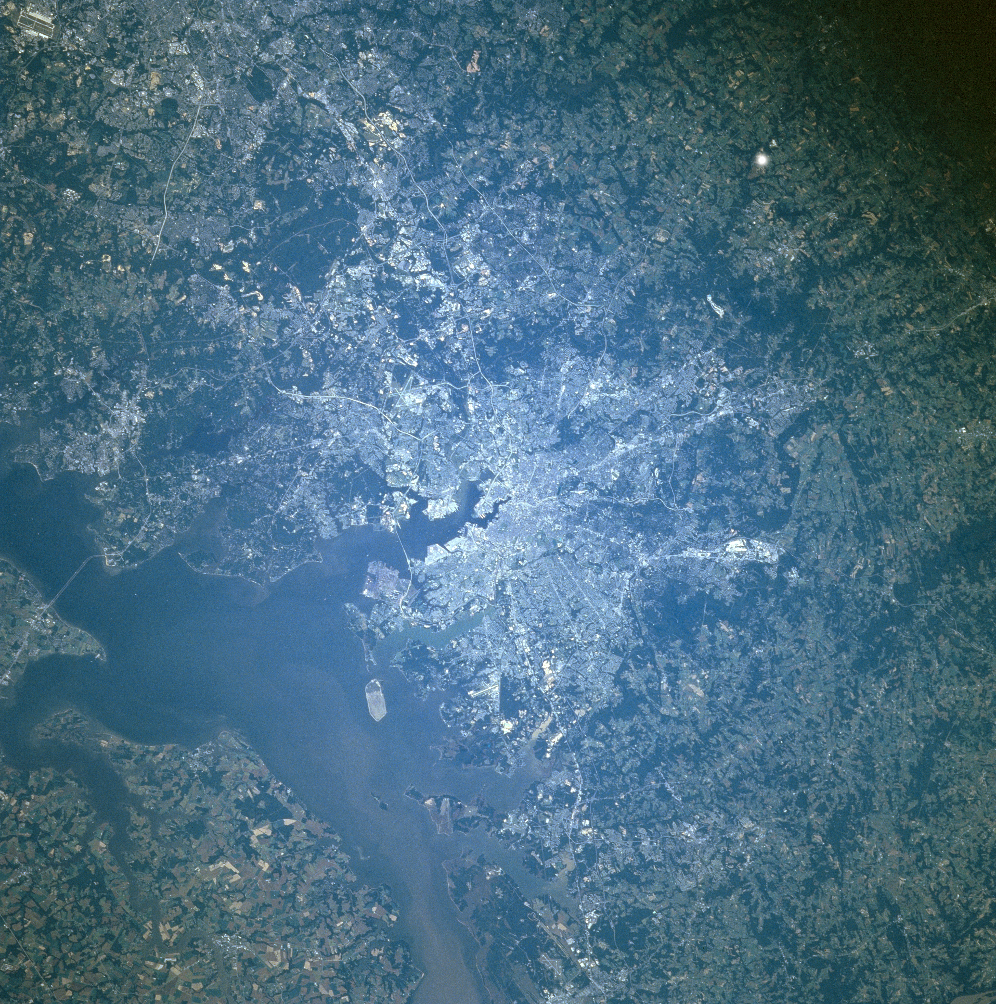
No GeoTIFF is available for this photo.Image Caption: STS079-783-026 Baltimore, Maryland, USA September 1996
Downtown Baltimore (center of the picture) is easy to identify as the focal point where numerous highways (light-colored lines) come together. This expansive highway network and the extensive urban area places Baltimore within Megalopolis, one of the world's largest populated land corridors, extending from Boston (MA) to Richmond (VA). Although the infrastructure of the port facilities can not be observed on this small scale image, the proximity of Baltimore Harbor to Chesapeake Bay illustrates that Baltimore's economy, at least in part, is tied to the fishing industry as well as seagoing international shipping and commerce. The intersecting runways of Baltimore-Washington International Airport are visible south of the downtown area. Two noted highway bridges are visible: the Francis Scott Key Bridge at the mouth of Baltimore Harbor and the Chesapeake Bay Bridge northeast of Annapolis.
Downtown Baltimore (center of the picture) is easy to identify as the focal point where numerous highways (light-colored lines) come together. This expansive highway network and the extensive urban area places Baltimore within Megalopolis, one of the world's largest populated land corridors, extending from Boston (MA) to Richmond (VA). Although the infrastructure of the port facilities can not be observed on this small scale image, the proximity of Baltimore Harbor to Chesapeake Bay illustrates that Baltimore's economy, at least in part, is tied to the fishing industry as well as seagoing international shipping and commerce. The intersecting runways of Baltimore-Washington International Airport are visible south of the downtown area. Two noted highway bridges are visible: the Francis Scott Key Bridge at the mouth of Baltimore Harbor and the Chesapeake Bay Bridge northeast of Annapolis.
