< STS41C-51-2426 >
| NASA Photo ID | STS41C-51-2426 |
| Focal Length | 90mm |
| Date taken | 1984.04.__ |
| Time taken | GMT |
Resolutions offered for this image:
640 x 480 pixels
640 x 480 pixels
Cloud masks available for this image:
Spacecraft nadir point:
Photo center point: 29.0° N, 92.0° W
Photo center point by machine learning:
Photo center point: 29.0° N, 92.0° W
Photo center point by machine learning:
Nadir to Photo Center:
Spacecraft Altitude: nautical miles (0km)
Country or Geographic Name: | USA-LOUISIANA |
Features: | PAN-GULF COAST, SEDIMENT, SUNGLINT |
| Features Found Using Machine Learning: | |
Cloud Cover Percentage: | 25 (11-25)% |
Sun Elevation Angle: | ° |
Sun Azimuth: | ° |
Camera: | Linhof |
Focal Length: | 90mm |
Camera Tilt: | High Oblique |
Format: | 2448: Fine Grain Aerochrome II color-reversal camera film, 70mm, process EA-5 |
Film Exposure: | Normal |
| Additional Information | |
| Width | Height | Annotated | Cropped | Purpose | Links |
|---|---|---|---|---|---|
| 640 pixels | 480 pixels | No | No | ISD 1 | Download Image |
Download Packaged File
Download a Google Earth KML for this Image
View photo footprint information
No GeoTIFF is available for this photo.Image Caption:
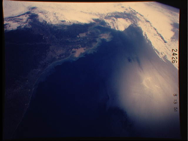
Lousiana Coast and Mississippi River Delta (April 1984, 28.5! N,
91.5! W)
This oblique, east-looking view of the northern Texas and Louisi-
ana coast was photographed from an altitude of 269 n.mi. (498 km)
using a Linhof camera equipped with a 90-mm lens and natural
color film. Galveston Island and Bay (A) can be seen in the lower
left portion of the view and the Mississippi River Delta (B) is
seen near the upper right corner. Heavily sedimented water, ap-
pearing light brown in color, marks outflow from the Mississippi
River and Vermilion Bay (C). The bright area along the right
border of the view (D) is sunglint from the Gulf of Mexico.
(STS41C-51-2426)
