< ISS030-E-234965 >
| NASA Photo ID | ISS030-E-234965 |
| Focal Length | 180mm |
| Date taken | 2011.12.30 |
| Time taken | 08:26:41 GMT |
Resolutions offered for this image:
1000 x 921 pixels 540 x 497 pixels 720 x 720 pixels 4288 x 2848 pixels 640 x 425 pixels
1000 x 921 pixels 540 x 497 pixels 720 x 720 pixels 4288 x 2848 pixels 640 x 425 pixels


Spacecraft nadir point: 17.1° S, 15.0° E
Photo center point: 18.5° S, 16.0° E
Photo center point by machine learning: 18.59° S, 16.01° E
Photo center point: 18.5° S, 16.0° E
Photo center point by machine learning: 18.59° S, 16.01° E
Nadir to Photo Center: Southeast
Spacecraft Altitude: 216 nautical miles (400km)

Country or Geographic Name: | NAMIBIA |
Features: | ETOSHA PAN, W. END, FLOODWATER, LAKES |
| Features Found Using Machine Learning: | |
Cloud Cover Percentage: | 10 (1-10)% |
Sun Elevation Angle: | 53° |
Sun Azimuth: | 106° |
Camera: | Nikon D2Xs Electronic Still Camera |
Focal Length: | 180mm |
Camera Tilt: | 25 degrees |
Format: | 4288E: 4288 x 2848 pixel CMOS sensor, RGBG imager color filter |
Film Exposure: | |
| Additional Information | |
| Width | Height | Annotated | Cropped | Purpose | Links |
|---|---|---|---|---|---|
| 1000 pixels | 921 pixels | No | Yes | Earth From Space collection | Download Image |
| 540 pixels | 497 pixels | Yes | Yes | Earth From Space collection | Download Image |
| 720 pixels | 720 pixels | Yes | Yes | NASA's Earth Observatory web site | Download Image |
| 4288 pixels | 2848 pixels | No | No | Download Image | |
| 640 pixels | 425 pixels | No | No | Download Image |
Download Packaged File
Download a Google Earth KML for this Image
View photo footprint information
No GeoTIFF is available for this photo.Image Caption:
Note: This caption refers to the image versions labeled "NASA's Earth Observatory web site".
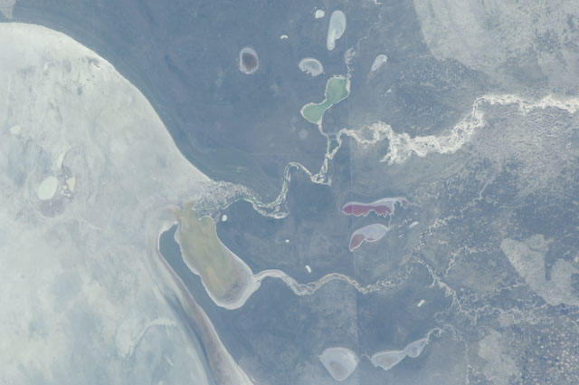
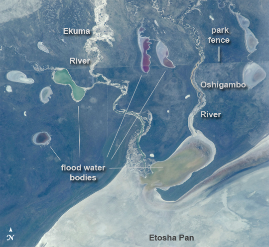
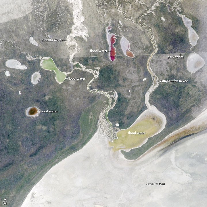
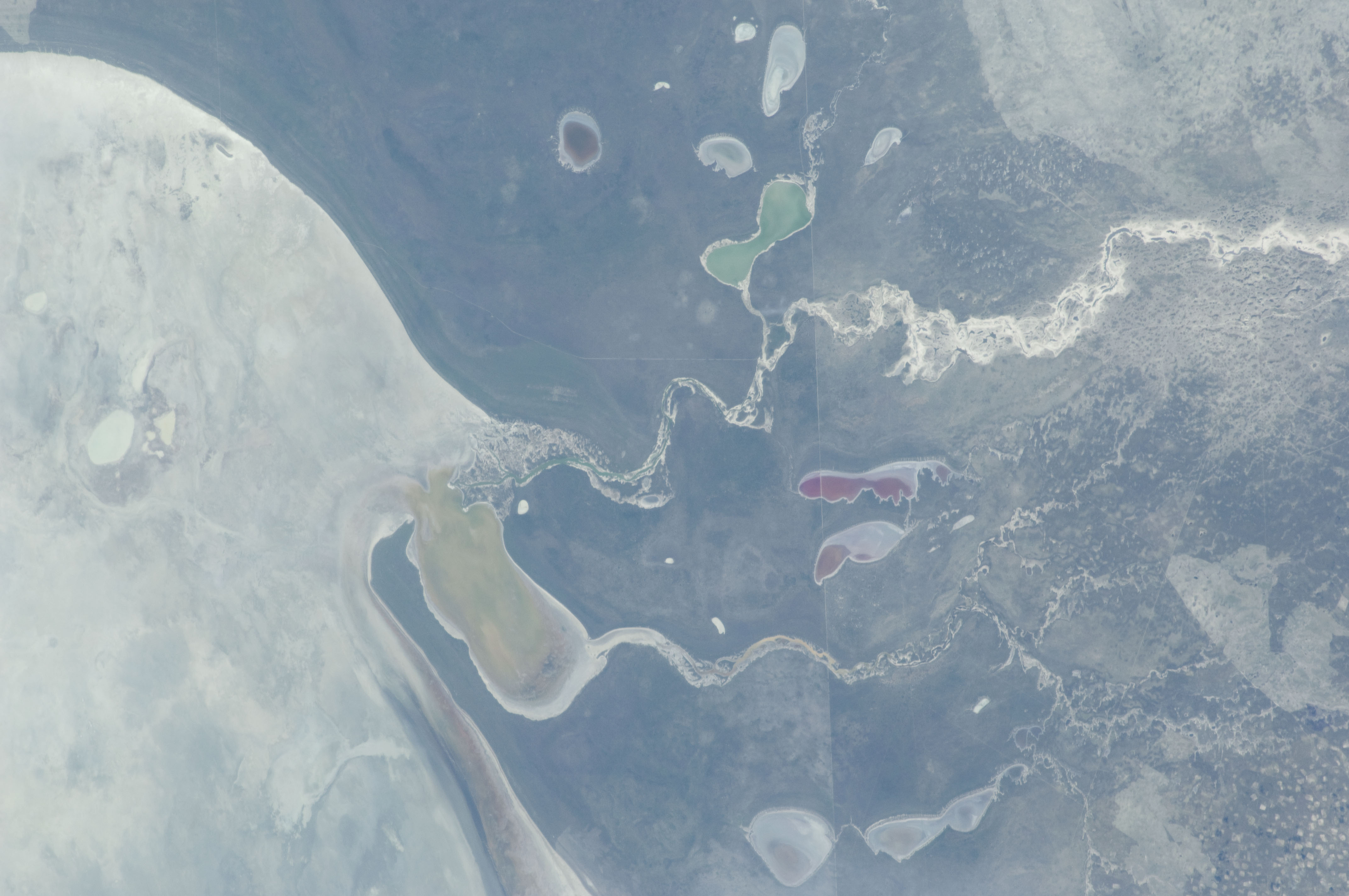
This astronaut photograph shows the white, salt-covered floor of the northwest corner of the great dry lake in northern Namibia known as the Etosha Pan (lower image margin). Two rivers, the Ekuma and Oshigambo, transport water from the north down to the Etosha Pan proper. In a relatively rare event, water from recent rains has flowed down the larger Ekuma River--in which it appears as a thin blue line within the generally light grey-green floodplain--and fills a lobe of the lake with light green water (lower right quarter of image). Water has also flowed into a small offshoot dry lake where it appears a brighter green (upper left quarter of image).
Other smaller lakes at image top center and image left show red and brown water colors. The different colors of lake water are determined by the interplay of water depth and resident organisms such as algae; the algae color varies depending on water temperature and salinity. A similar process is observed in pink and red floodwaters ponded in Lake Eyre, a usually dry lake in Australia's arid center. In this case it is known that the coloration is indeed due to algae growth.
Typically, little river water or sediment reaches the floor of the Etosha dry lake because water seeps into the riverbeds along their courses. The floor of the pan itself is seldom seen with even a thin sheet of water. In this image, there was enough surface flow to reach the pan, but too little to flow beyond the inlet bay. A prior flood event, when water entered the pan via the Oshigambo River, was documented in astronaut imagery in 2006.
The straight line that crosses the image from upper left to upper right is the northern fence line of Namibia's Etosha National Park. This straight, 3 meter-high fence keeps wildlife from crossing into the numerous small farms of the relatively densely populated Owambo region of Namibia, north of the pan. The large Etosha dry lakebed (120 km or 75 mi long) is the center of Namibia's largest wildlife park, a major tourist attraction.
Note: This caption refers to the image versions labeled "NASA's Earth Observatory web site".
This astronaut photograph shows the white, salt-covered floor of the northwest corner of the great dry lake in northern Namibia known as the Etosha Pan (lower image margin). Two rivers, the Ekuma and Oshigambo, transport water from the north down to the Etosha Pan proper. In a relatively rare event, water from recent rains has flowed down the larger Ekuma River--in which it appears as a thin blue line within the generally light grey-green floodplain--and fills a lobe of the lake with light green water (lower right quarter of image). Water has also flowed into a small offshoot dry lake where it appears a brighter green (upper left quarter of image).
Other smaller lakes at image top center and image left show red and brown water colors. The different colors of lake water are determined by the interplay of water depth and resident organisms such as algae; the algae color varies depending on water temperature and salinity. A similar process is observed in pink and red floodwaters ponded in Lake Eyre, a usually dry lake in Australia's arid center. In this case it is known that the coloration is indeed due to algae growth.
Typically, little river water or sediment reaches the floor of the Etosha dry lake because water seeps into the riverbeds along their courses. The floor of the pan itself is seldom seen with even a thin sheet of water. In this image, there was enough surface flow to reach the pan, but too little to flow beyond the inlet bay. A prior flood event, when water entered the pan via the Oshigambo River, was documented in astronaut imagery in 2006.
The straight line that crosses the image from upper left to upper right is the northern fence line of Namibia's Etosha National Park. This straight, 3 meter-high fence keeps wildlife from crossing into the numerous small farms of the relatively densely populated Owambo region of Namibia, north of the pan. The large Etosha dry lakebed (120 km or 75 mi long) is the center of Namibia's largest wildlife park, a major tourist attraction.
