< STS043-151-220 >
| NASA Photo ID | STS043-151-220 |
| Focal Length | 90mm |
| Date taken | 1991.08.10 |
| Time taken | 04:31:21 GMT |
Resolutions offered for this image:
640 x 480 pixels
640 x 480 pixels
Cloud masks available for this image:
Spacecraft nadir point: 23.0° N, 54.8° E
Photo center point: 25.5° N, 51.0° E
Photo center point by machine learning:
Photo center point: 25.5° N, 51.0° E
Photo center point by machine learning:
Nadir to Photo Center: Northwest
Spacecraft Altitude: 175 nautical miles (324km)
Country or Geographic Name: | SAUDI ARABIA |
Features: | QATAR, HAZY, KUWAIT SMOKE |
| Features Found Using Machine Learning: | |
Cloud Cover Percentage: | 30 (26-50)% |
Sun Elevation Angle: | 34° |
Sun Azimuth: | 86° |
Camera: | Linhof |
Focal Length: | 90mm |
Camera Tilt: | High Oblique |
Format: | QX868: Kodak, natural color positive, Ektachrome QX868(5017 emulsion), ASA 64, thin base |
Film Exposure: | Under Exposed |
| Additional Information | |
| Width | Height | Annotated | Cropped | Purpose | Links |
|---|---|---|---|---|---|
| 640 pixels | 480 pixels | No | No | ISD 1 | Download Image |
Download Packaged File
Download a Google Earth KML for this Image
View photo footprint information
No GeoTIFF is available for this photo.Image Caption:
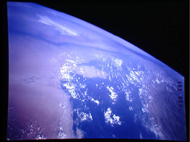
S43-151-220 - Kuwaiti Smoke Plumes
This view up the Persian Gulf across Qatar, northern Saudi Ara-
bia, Kuwait, and Iraq shows an excursion of the smoke plumes from
the Kuwaiti oil fires, within the overall very dusty atmosphere.
A small plume from the fires north of Kuwait city extends a rel-
tively short distance across the head of the Gulf. A much larger,
discrete plume from the fires south of Kuwait City extends south-
ward toward the center of Saudi Arabia before beginning to spread
out and become more diffuse. On the previous day, the large plume
was blown westward across Iraq. In this view, this westward mass
of smoke can be seen entrained in north-flowing winds and heading
toward the southern Soviet Union. The smoke moving north into the
Soviet has broken through the low-level inversion layer that has
capped most of the smoke to date. Linhof camera, 90mm lens, 10
August 1991, 4:31 GMT
This view up the Persian Gulf from the Qatar Peninsula into southern Iraq (25.5N, 51.0E) shows an excursion of the smoke plumes from the Kuwait oil fires set during the short Persian Gulf War. Smoke from the fires north of Kuwait City, extends across the Persian Gulf while a larger smoke plume from the southern fires heads into southern Saudi Arabia before beginning to spread out and become more diffuse.
