< STS043-151-206 >
| NASA Photo ID | STS043-151-206 |
| Focal Length | 90mm |
| Date taken | 1991.08.10 |
| Time taken | 04:26:44 GMT |
Resolutions offered for this image:
640 x 480 pixels
640 x 480 pixels
Cloud masks available for this image:
Spacecraft nadir point: 27.2° N, 36.4° E
Photo center point: 29.0° N, 33.0° E
Photo center point by machine learning:
Photo center point: 29.0° N, 33.0° E
Photo center point by machine learning:
Nadir to Photo Center: Northwest
Spacecraft Altitude: 176 nautical miles (326km)
Camera: | Linhof |
Focal Length: | 90mm |
Camera Tilt: | High Oblique |
Format: | QX868: Kodak, natural color positive, Ektachrome QX868(5017 emulsion), ASA 64, thin base |
Film Exposure: | Normal |
| Additional Information | |
| Width | Height | Annotated | Cropped | Purpose | Links |
|---|---|---|---|---|---|
| 640 pixels | 480 pixels | No | No | ISD 1 | Download Image |
Download Packaged File
Download a Google Earth KML for this Image
View photo footprint information
No GeoTIFF is available for this photo.Image Caption:
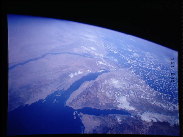
S43-151-206 - Sinai Peninsula
This oblique northwestward-looking view shows the Sinai Peninsu-
la, the eastern Arabian Desert, the Nile River valley, and the
Qatara Depression in Egypt. Mount Sinai is visible in the lower
left center of the view. Dusty air, typical of North Africa dur-
ing STS-43, is well-displayed near the horizon. Linhof camera,
90mm lens,10 August 1991, 4:27 GMT
This oblique northwestward looking panorama view shows the southeastern Mediterranean (29.0N, 33.0E) in great detail. The Sinai Peninsula, the eastern Arabian Desert, the Nile River Valley and Delta as well as the Qatara Depression in Egypt are all prominently portrayed. Even Mt. Sinai is visible in the lower left center of the view. The dusty atmosphere of the region can be seen as a general haziness in the atmosphere.
