< STS062-151-182Z >
| NASA Photo ID | STS062-151-182Z |
| Focal Length | 90mm |
| Date taken | 1994.03.__ |
| Time taken | GMT |
Resolutions offered for this image:
640 x 480 pixels
640 x 480 pixels
Cloud masks available for this image:
Spacecraft nadir point:
Photo center point: 15.0° N, 27.0° E
Photo center point by machine learning:
Photo center point: 15.0° N, 27.0° E
Photo center point by machine learning:
Nadir to Photo Center:
Spacecraft Altitude: nautical miles (0km)
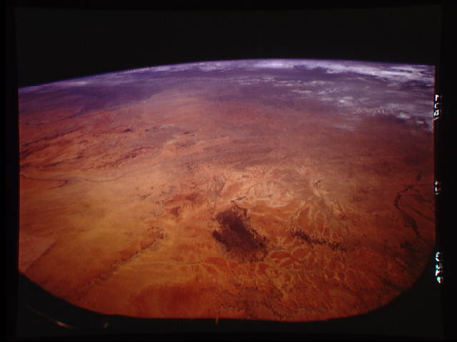
Country or Geographic Name: | SUDAN |
Features: | MEIDOB HILLS |
| Features Found Using Machine Learning: | |
Cloud Cover Percentage: | 10 (1-10)% |
Sun Elevation Angle: | ° |
Sun Azimuth: | ° |
Camera: | Linhof |
Focal Length: | 90mm |
Camera Tilt: | High Oblique |
Format: | 5046: Kodak, natural color positive, Lumiere 100/5046, ASA 100, standard base |
Film Exposure: | Under Exposed |
| Additional Information | |
| Width | Height | Annotated | Cropped | Purpose | Links |
|---|---|---|---|---|---|
| 640 pixels | 480 pixels | No | No | ISD 1 | Download Image |
Download Packaged File
Download a Google Earth KML for this Image
View photo footprint information
No GeoTIFF is available for this photo.Image Caption: This east-looking view shows most of the east-west extent of the country of Sudan. The foreground shows a vegetationless and almost uninhabited region of northwest Sudan. The rich earth colors are ancient soils (browner and redder tones), a concentrated mass of what may be volcanic cinder cones (dark brown dots - center) and dune and younger river sediments (yellows). The photo would have been difficult to locate had it not been for two recognizable features in the background: a visually well-know inselberg ("island mountain" - top center) on the large west-bank tributary of the White Nile; and the confluence of the Blue and White Nile Rivers, with the great cotton developments of the Gezira Scheme between them (top left). The Red Sea coast is almost obscured by a dust cloud but can be discerned running across the top of the picture. The clouds at top may be developing over the coastal ranges of Saudi Arabia beyond the Red Sea.
