< ISS040-E-17260 >
| NASA Photo ID | ISS040-E-17260 |
| Focal Length | 200mm |
| Date taken | 2014.06.23 |
| Time taken | 09:54:58 GMT |


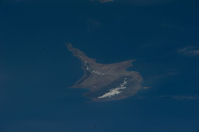
Spacecraft nadir point: 37.0° N, 44.9° E
Photo center point:
Photo center point by machine learning: 35.18° N, 32.88° E
Photo center point:
Photo center point by machine learning: 35.18° N, 32.88° E
Nadir to Photo Center:
Spacecraft Altitude: 221 nautical miles (409km)

Country or Geographic Name: | |
Features: | |
| Features Found Using Machine Learning: | |
Cloud Cover Percentage: | 1 (1-10)% |
Sun Elevation Angle: | 72° |
Sun Azimuth: | 224° |
Camera: | NIKON D3S S/N: 2007945 |
Focal Length: | 200mm |
Camera Tilt: | |
Format: | |
Film Exposure: | |
| Additional Information | |
| Width | Height | Annotated | Cropped | Purpose | Links |
|---|---|---|---|---|---|
| 4256 pixels | 2832 pixels | No | No | Download Image | |
| 640 pixels | 426 pixels | No | No | Download Image |
Download Packaged File
Download a Google Earth KML for this Image
View photo footprint information
No GeoTIFF is available for this photo.Image Caption: ISS040-E-017260 (23 June 2014) --- One of the Expedition 40 crew members aboard the International Space Station used a 200mm focal length to photograph this image of the island of Cyprus in the eastern Mediterranean Sea on June 23, 2014.
